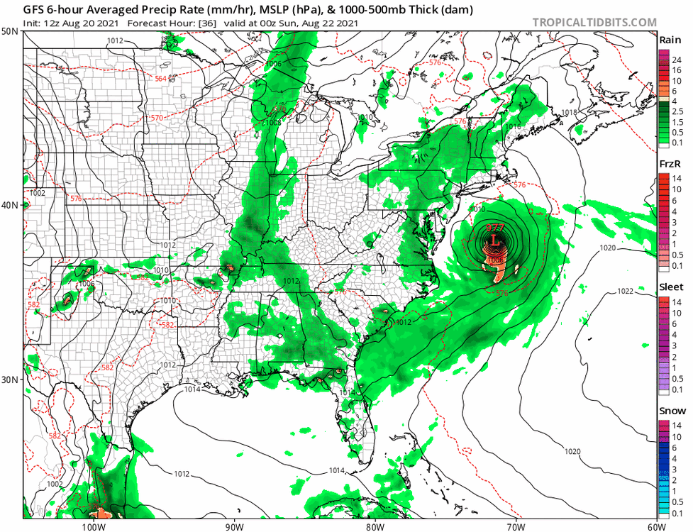
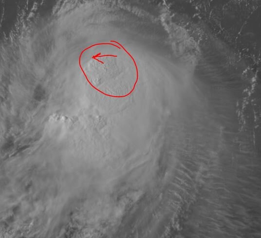
Everyones phones blowing up with the Emergency Broadcast msg for Hurricane warnings now in effect for the Southern areas.
Henri Local Watch/Warning Statement/Advisory Number 20
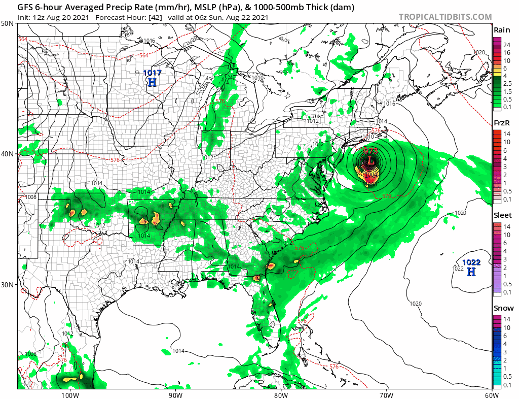
National Weather Service New York NY AL082021
501 PM EDT Fri Aug 20 2021
NYZ081-210515-
/O.NEW.KOKX.SS.W.1008.210820T2101Z-000000T0000Z/
/O.NEW.KOKX.HU.W.1008.210820T2101Z-000000T0000Z/
/O.UPG.KOKX.SS.A.1008.000000T0000Z-000000T0000Z/
/O.UPG.KOKX.HU.A.1008.000000T0000Z-000000T0000Z/
Southeast Suffolk-
501 PM EDT Fri Aug 20 2021
...HURRICANE WARNING IN EFFECT...
...STORM SURGE WARNING IN EFFECT...
A Hurricane Warning means hurricane-force winds are expected
somewhere within this area within the next 36 hours
A Storm Surge Warning means there is a danger of life-threatening
inundation, from rising water moving inland from the coastline,
somewhere within this area within the next 36 hours
* LOCATIONS AFFECTED
- Mastic Beach
- Hampton Bays
- Montauk Point
* WIND
- LATEST LOCAL FORECAST: Equivalent Strong Tropical Storm force
wind
- Peak Wind Forecast: 50-65 mph with gusts to 80 mph
- Window for Tropical Storm force winds: Saturday evening
until early Monday morning
- THREAT TO LIFE AND PROPERTY THAT INCLUDES TYPICAL FORECAST
UNCERTAINTY IN TRACK, SIZE AND INTENSITY: Potential for wind 74
to 110 mph
- The wind threat has increased from the previous assessment.
- PLAN: Plan for life-threatening wind of equivalent CAT 1 or
2 hurricane force.
- PREPARE: Remaining efforts to protect life and property
should be urgently completed. Prepare for considerable wind
damage.
- ACT: Move to safe shelter before the wind becomes hazardous.
- POTENTIAL IMPACTS: Extensive
- Considerable roof damage to sturdy buildings, with some
having window, door, and garage door failures leading to
structural damage. Mobile homes severely damaged, with some
destroyed. Damage accentuated by airborne projectiles.
Locations may be uninhabitable for weeks.
- Many large trees snapped or uprooted along with fences and
roadway signs blown over.
- Some roads impassable from large debris, and more within
urban or heavily wooded places. Several bridges, causeways,
and access routes impassable.
- Large areas with power and communications outages.
* STORM SURGE
- LATEST LOCAL FORECAST: Life-threatening storm surge possible
- Peak Storm Surge Inundation: The potential for 2-4 feet
above ground somewhere within surge prone areas
- Window of concern: early Sunday morning until Sunday evening
- THREAT TO LIFE AND PROPERTY THAT INCLUDES TYPICAL FORECAST
UNCERTAINTY IN TRACK, SIZE AND INTENSITY: Potential for storm
surge flooding greater than 3 feet above ground
- The storm surge threat has increased from the previous
assessment.
- PLAN: Plan for life-threatening storm surge flooding of
greater than 3 feet above ground.
- PREPARE: Evacuation efforts and flood preparations should
soon be brought to completion before conditions become
unsafe.
- ACT: Leave immediately if evacuation orders are given for
your area to avoid being cut off from emergency services or
needlessly risk lives.
- POTENTIAL IMPACTS: Significant
- Areas of inundation with storm surge flooding accentuated
by waves. Damage to several buildings, mainly near the
coast.
- Sections of near shore escape routes and secondary roads
become weakened or washed out, especially in usually
vulnerable low spots. Flood control systems and barriers
may become stressed.
- Major beach erosion with heavy surf breaching dunes. Very
dangerous surf and rip currents.
- Moderate damage to marinas, docks, boardwalks, and piers.
Several small craft broken away from moorings, especially
in unprotected anchorages.
* FLOODING RAIN
- LATEST LOCAL FORECAST:
- Peak Rainfall Amounts: Additional 3-6 inches, with locally
higher amounts
- THREAT TO LIFE AND PROPERTY THAT INCLUDES TYPICAL FORECAST
UNCERTAINTY IN TRACK, SIZE AND INTENSITY: Potential for major
flooding rain
- The flooding rain threat has increased from the previous
assessment.
- PLAN: Emergency plans should include the potential for
major flooding from heavy rain. Evacuations and rescues are
likely.
- PREPARE: Strongly consider protective actions, especially
if you are in an area vulnerable to flooding.
- ACT: Heed any flood watches and warnings. Failure to take
action will likely result in serious injury or loss of life.
- POTENTIAL IMPACTS: Extensive
- Major rainfall flooding may prompt many evacuations and
rescues.
- Rivers and streams may rapidly overflow their banks in
multiple places. Small streams, creeks, canals, and ditches
may become dangerous rivers. Flood control systems and
barriers may become stressed.
- In hilly terrain, destructive runoff may run quickly down
valleys, and increase susceptibility to rockslides and
mudslides.
- Flood waters can enter many structures within multiple
communities, some structures becoming uninhabitable or
washed away. Many places where flood waters may cover
escape routes. Streets and parking lots become rivers of
moving water with underpasses submerged. Driving conditions
become dangerous. Many road and bridge closures with some
weakened or washed out.
* TORNADO
- LATEST LOCAL FORECAST:
- Situation is unfavorable for tornadoes
- THREAT TO LIFE AND PROPERTY THAT INCLUDES TYPICAL FORECAST
UNCERTAINTY IN TRACK, SIZE AND INTENSITY: Tornadoes not expected
- The tornado threat has remained nearly steady from the
previous assessment.
- PLAN: Tornadoes are not expected. Showers and thunderstorms
with gusty winds may still occur.
- PREPARE: Little to no preparations needed to protect
against tornadoes at this time. Keep informed of the latest
tornado situation.
- ACT: Listen for changes in the forecast.
- POTENTIAL IMPACTS: Little to None
- Little to no potential impacts from tornadoes.
* FOR MORE INFORMATION:
- http://scoem.suffolkcountyny.gov
- https://weather.gov/nyc
- https://ready.gov/hurricanes


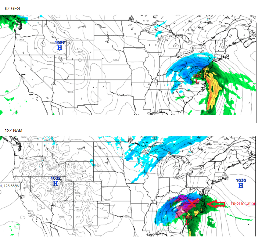
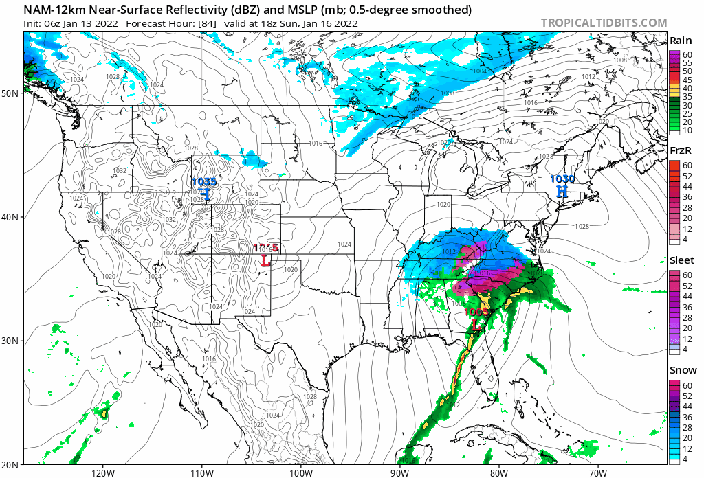
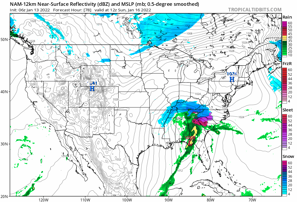
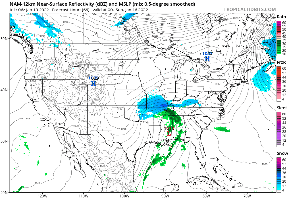
 very positive changes on the NAM vs 6z.