AdamHLG
-
Posts
512 -
Joined
-
Last visited
Content Type
Profiles
Blogs
Forums
American Weather
Media Demo
Store
Gallery
Everything posted by AdamHLG
-
Why is this still stickied? Just curious. .
-
6 flurries over past 15 minutes in Towson. Enough to officially and technically welcome the snowfall of winter 2019-2020.
-
Hey all I have a random question. I have been on Android for a decade and just switched to the new iPhone 11. When on Android, I used an app called NWS NOW to very easily read the area forecast discussions from the NWS in lieu of a website bookmark (which made the discussion very easy to read in nice formatted text within the app without needing to zoom, etc). Does anyone know of an app for iPhone that would make it easy to read these discussions or must I revert back to a web page bookmark? And while I am asking, what app are you guys using for fast and immediate NWS weather alerts for iPhone? I am using Weather Line for regular weather status (I like the interface) and Storm Shield for alerts. But maybe there is a better app for nerds like us. Thanks.
-
And most importantly post some pics! Sent from my Pixel 3 XL using Tapatalk
-
You know the weather here is boring when you start checking Tropical Disturbance 3 on the east side of the Cabo Verde islands 3 times a day for any sign of development. tl;dr: No further development. At least the NFL starts tonight.
-
There's a Polar Coaster coming this winter. Can't make this up. https://www.cnn.com/2019/08/27/weather/farmers-almanac-weather-forecast-2020-wxc-trnd/index.html
-
Its been a great night drinking at home with friends and about to go to bed but I had a great weather day today. So if you're just browsing this thread here's a random story. It's long winded because I'm a bit drunk. Went to a friend's house with my wife in Arnold MD near Annapolis and they took us out on their boat. I've been out on the Chesapeake maybe twice in my life and today was the second time. When I left Owings Mills at 11 am it felt like a typical summer day. But when we got to Arnold at noonish it just felt... Uncomfortably humid. Noticeable as in high CAPE humid. I looked at the sky and there was all sun and some cumulus out in the way distance. I commented before we left on the boat that it felt like.... Instability. Of course the three others said "what?" And I said nevermind. But I felt it in my bones. We head out at 2 pm. Now the last thing I want to do is be out in a boat with CG lightning. And I feel it in the atmosphere that it's gonna happen but it's an almost clear sky. 30 min later while near the Chesapeake Bay bridge on the boat I see a darkening haze to the north with wide open chesapeake bay visibility. I check my RadarScope app. It's a fairly isolated red and yellow shower... But pretty large surface area. Seems to be stationary. I keep an eye on it. Over next 10 min it's getting significantly darker to the north. And then I see a cloud finger emerging that gave me pause. I look again and now I see CG strikes on RadarScope and a ST Warning and Marine Warning to the north. Storm is still almost stationary on RadarScope and to my eyes. I zoom out on app and there is no other storm for 125 miles in any direction. But this storm is a lone wolf in an otherwise wide open chesapeake bay sunny sky. It's beautiful. Ok so I may not know how to Captain a boat, but I know how to be a storm spotter. This storm is growing. And Captain wants to go get gas but we don't "have to" get gas. We're heading into the now much darker sky and I see the cloud finger more pronounced and think to myself that if today were a tornado day I would know that. But severe storms can spawn rotation right? So 'is it' just a cloud finger..... Or something more? I pull up RadarScope again as my index of suspicion is growing by the minute and now on RadarScope there are lots of CG strikes and now there is purple in the cell. I look up and see a CG strike in the way distance.... The first one we see. A big one. But very far away. It was red. It was surreal. It was at that moment the storm started it's movement on RadarScope. And it was moving towards us and growing in size. Impressively rapidly. Yep. Time to go in. We do a 180 and take the 15 min ride to our friends dock. Upon arrival the sky is now deep grey and CG strikes getting closer and loud rumbling beautiful thunder. We button up boat. Head up to house with a deck in perfect view of the approaching storm. O yeah by now we are under a ST Warning and Marine Warning over our friends house. I am pacing out how long until it's truly too dangerous to stay outside and BAM a very bright flash and LOUD bang of thunder 2 or 3 seconds later. O yeah time to go inside now. 10 minutes later sheets of rain, and numerous CG strikes very close by. And then the hail starts. Pea sized hail and lots of it. I open RadarScope. It's purple over us. I zoom out. It is one tiny small storm right over us drifting south. What luck I had as a storm lover! For all those near misses to hit a jackpot. Today I was a 1 percenter. 30 min later it's sunny. All done. And that's it. But here is why it is cool. I felt that CAPE today. I knew something was up. And I was right. And to use my weather skills and skywatching skills to chart that storm and have it actually hit us head on was really lucky... For those of us that love storms. So I had to share that here cause nobody gets it but you guys. Thanks for listening. Sent from my Pixel 3 XL using Tapatalk
- 124 replies
-
- 11
-

-
This was near University of Baltimore. Pretty significant hail! (not my tweet)
-
Last night around 9:30 pm we had a respectable thunderstorm with heavy downpour over Chestnut Ridge (northern Baltimore County). Not severe by any stretch however I am taking what I can get during this week of "active weather" that was predicted last Saturday. But other than last night this week has been a fail for me. I am somewhat optimistic for today - the last day of this "pattern" until we reload next week. So maybe today - the day folks let their guard down or give up on the game - is the day we profit!
-
It's starting to feel like winter waiting for these storms. Just sayin.
- 2,802 replies
-
- 1
-
-
- severe
- thunderstorms
- (and 4 more)
-
Best Mid-Atlantic winter storm of the last 40 years
AdamHLG replied to PrinceFrederickWx's topic in Mid Atlantic
I thought PD1 was in 2003 and PDII was in 2006. Am i wrong about that? -
I have one but can't post till Sunday. Check back.
-
-
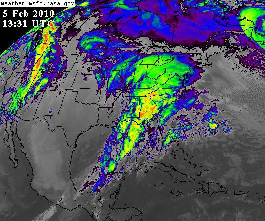
This was my favorite image from Snowmageddon. I had been hyping this storm to my Facebook Profile for 4 days prior to the storm. I was going BIG the whole way (thanks to this Board - well, I mean the predecessor Board, but same folks). 36 hours before Snowmageddon started, I posted "2.8 - 3.2 QPF !!!!!" on Facebook. Of course nobody knew what that meant, so my post read "If this storm verifies, it will be the largest storm in history to ever hit Baltimore (it wasn't - that was "officially" February 15-18, 2003) (see footnote 1 below). When people asked me what that meant, I said "28 to 32 inches". Many gave me a "like" button, some said "Bring it", etc., but all the other posters made comments such as "nobody else on tv is/are calling for that" (remember that was 36 hours prior to start). When it verified, I was a local hero to my Facebook friends. And when I hit again on last weeks storm when TV was at "low qpf and rain", I became their official winter met (again thanks to all you). Look at that thing (carefully) !!!! Do you see that? It is touching CANADA and COSTA RICA at the same time!!!! My comment when I posted to Facebook was simply "Here she comes!" And look behind that storm back in the Pac NW. You know what that was, right? That was Snowmageddon II. Such an AWESOME winter last year. Adam Footnote 1: First, it must be remembered that Snowmageddon was an event, not a storm. There were two storms within, more or less, 3 days. I will call them "Snowmageddon I" and "Snowmageddon II". But was "Snowmageddon I" the recordbreaker at BWI? You see, when it comes to measuring snow, the people at BWI, well, they "did it wrong". See http://baltimore.cbs...t-bwi-marshall/ Snowmageddon (the event) apparently also caused this controversy: http://weblogs.maryl..._all_ranke.html Unless I am mistaken, to-date we do not have an "official" calculation for Snowmageddon I at BWI.