

wthrmn654
-
Posts
3,149 -
Joined
-
Last visited
Content Type
Profiles
Blogs
Forums
American Weather
Media Demo
Store
Gallery
Everything posted by wthrmn654
-
Maybe be a little premature to make any calls like that just yet. By tomorrow 8 am if nothing has really changed by then I'd start to have doubts.
-

2024 Atlantic Hurricane Season
wthrmn654 replied to Stormchaserchuck1's topic in Tropical Headquarters
Anyone see that sneaky system in the northern Atlantic with 40%chance of formation? Also 2nd formation coming off of Africa.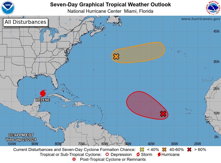
-
-
That one wrap/ sliver on the western side where there's lack of clouds would usually imply there's dry air in that location. Atleast that's how it would present itself the last few tropical systems this year.
-
Looking at the airmass composite, which is used for seeing dry air, it's still affecting it. Didn't expect to see dry air getting mixed into the equation at all honestly. ----- Current Analysis ----- Date : 26 SEP 2024 Time : 001020 UTC Lat : 23:01:15 N Lon : 86:34:59 W CI# /Pressure/ Vmax 3.8 / 979.5mb/ 61.0kt Final T# Adj T# Raw T# 3.7 3.8 3.8 Center Temp : -40.6C Cloud Region Temp : -57.1C Scene Type : EMBEDDED CENTER CLOUD REGION Subtropical Adjustment : OFF Extratropical Adjustment : OFF Positioning Method : FORECAST INTERPOLATION Ocean Basin : ATLANTIC Dvorak CI > MSLP Conversion Used : CKZ Method Tno/CI Rules : Constraint Limits : NO LIMIT Weakening Flag : ON Rapid Dissipation Flag : OFF
-
OK, by far the coolest site I've stumbled upon overall and spells the storm and actual track in motion, radar, etc tons of info. https://zoom.earth/storms/helene-2024/#overlays=crosshair
-
I see the spin and possible center on cancan radar. https://www.rainviewer.com/radars/mexico.html
-
The 00z gfs and euro ensembles have done pretty good with the short term track direction compared some of the other models.
-
Potential Tropical Cyclone Eight—50mph/1006mb
wthrmn654 replied to WxWatcher007's topic in Tropical Headquarters
Recon in 95l now -
Exactly that's what I eat heading on weather Channel, had they had a high tide at exact time of hit and maybe a little slower I think flood damage may of been 5x worse. Waters more destructive then most think
-
Overall, how did they do down south? Heard on TV wind wasn't really a thing is now water, mostly fresh water or fresh and salt? Haven't paid much attention honestly.
-
Tides are manageable thankfully minus the areas to the right and closest to center.
-
looks like lowest pressure recorded will be 976mb unless it drops more wow
-
90.6knots gust measured (104 mph)
-
station got as low as 978.6mb winds are even starting to lower pressure might be going up now but wow i expect it to go lower!
-
dulac is the only station that i have seen that forecast and current match, no lie and i do expect them to see surge, there in the red zone of areas and do have a water level station though its mising a forcast thats shows flood levels. Mississippi River Delta Basin at Bayou Grand Caillou at Dulac (noaa.gov)
-
-
only 12nm away from station at ground zero, seems more rare then common to have hurricane actually go over or near a weather station.
-
981.3mb! 987 to 981 in 29 minutes
-
another storm doing opposite of what was expected didnt go crazy strong like some models suggested then when its suppose to be weakening from bad enviromental conditions, its holding and strengthening!
-
I should have prefaced that it's also a bit early. Let the eyewall come ashore and give the datasets time to update. Hope that the surge is mitigated, but these are unknowns. We'll just have to hope for the best and wait and see. im sure you familiar but heres what ive been looking at, make sure to select partner and the other station options as thats nws ones... realtime data apparently according to the site. like you said eastern areas, they had minor flooding stages for the past 2 high tides but barely at that. tidesandcurrents.noaa.gov/inundationdb/cidstorm.html?stormname=Francine
-
god dam! 985.2MB 88mph gust . this station going get hammered.
-
I should have prefaced that it's also a bit early. Let the eyewall come ashore and give the datasets time to update. Hope that the surge is mitigated, but these are unknowns. We'll just have to hope for the best and wait and see. i get that but its also Realtime data updated either hourly or every 15 minutes. faster moving storm, hitting at dead low time, its a double win, and thats a good thing! rain and wind though, nothing going stop that unfortunately
-
latest nhc dicussion, The new track guidance is a little faster than for the previous advisory, so the new forecast track is similar to, but faster than, the previous track.
-
areas to the east, are well below guidance as well the one that shows 13 ft is well east but its only at 7 and its no where near flood stage, in fact most areas are forecast only minor if even that. timing was a big plus


