wthrmn654
-
Posts
3,069 -
Joined
-
Last visited
Content Type
Profiles
Blogs
Forums
American Weather
Media Demo
Store
Gallery
Everything posted by wthrmn654
-

2/13 Light/Moderate Snowfall Nowcasting & Observations
wthrmn654 replied to Northof78's topic in New York City Metro
-
2/13 Light/Moderate Snowfall Nowcasting & Observations
wthrmn654 replied to Northof78's topic in New York City Metro
-
2/13 Light/Moderate Snowfall Nowcasting & Observations
wthrmn654 replied to Northof78's topic in New York City Metro
-
2/13 Light/Moderate Snowfall Nowcasting & Observations
wthrmn654 replied to Northof78's topic in New York City Metro
-
2/13 Light/Moderate Snowfall Nowcasting & Observations
wthrmn654 replied to Northof78's topic in New York City Metro
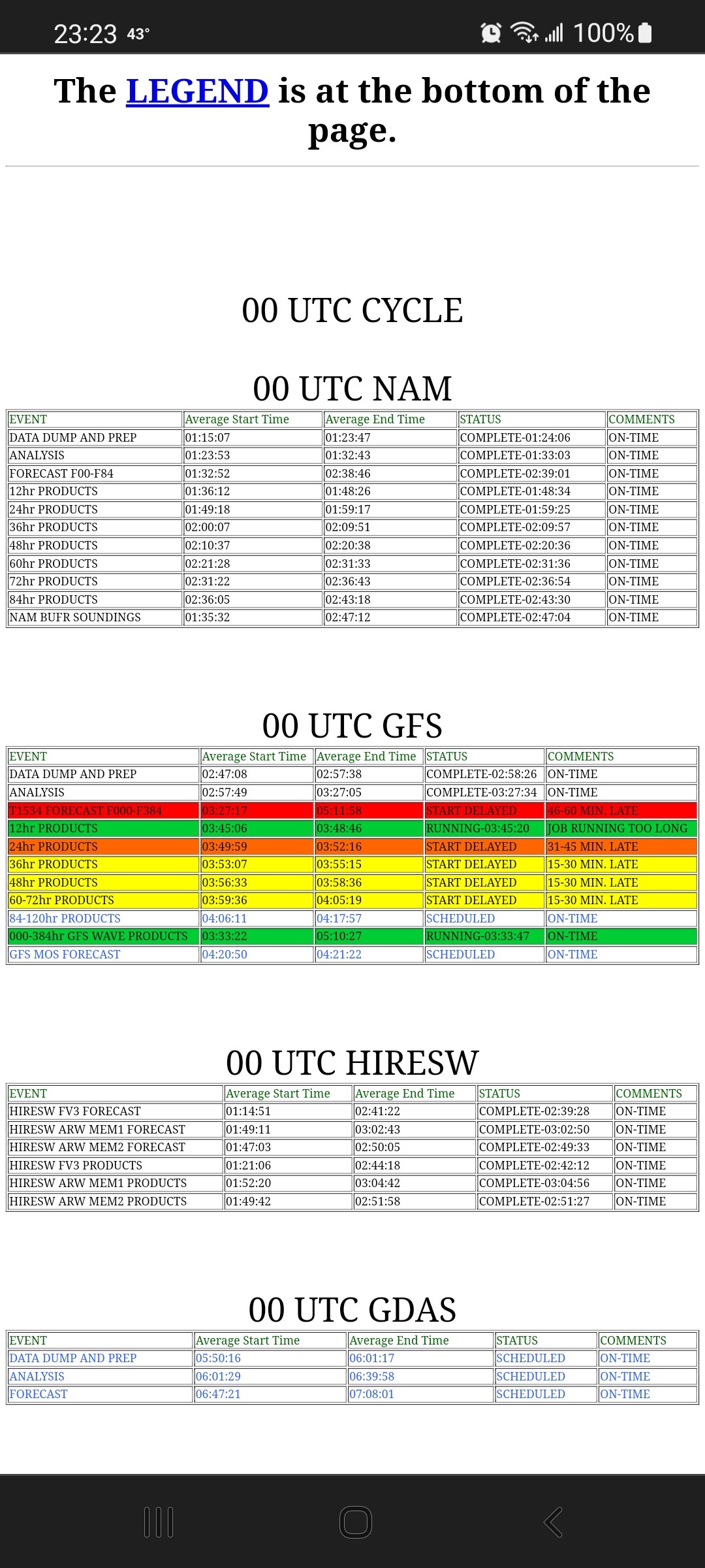
Gfs running late, one message says run taking to long.... -
2/13 Light/Moderate Snowfall Nowcasting & Observations
wthrmn654 replied to Northof78's topic in New York City Metro
Still some uncertainty re snow chances from late Sat night into Sunday as low pressure passes well to the SE and the area falls underneath or very close to upper jet and mid level frontogenetic forcing. ECMWF, after trending farther south for a couple of cycles, has come back a little NW, while other global models are farther south/east. Forecast splits the difference, with chance snow for the entire area during this time frame. Liquid equivalent QPF forecast by the operational models is mostly less than 1/10 inch throughout per GFS/Canadian, and about 1/10 inch from NYC east per ECMWF and less NW. Meanwhile, ensemble means suggest a little more QPF, with about 1/10 inch from NYC north/west and 1-2 tenths for Long Island. SLR should be fairly high though in the cold air mass, running between 12-15:1, so a 1-2 inch snowfall still seems quite possible, with the higher amts to the east and south of NYC, possibly also in the higher elevations inland. -
2/13 Light/Moderate Snowfall Nowcasting & Observations
wthrmn654 replied to Northof78's topic in New York City Metro
-
2/13 Light/Moderate Snowfall Nowcasting & Observations
wthrmn654 replied to Northof78's topic in New York City Metro
00z 12z (so far) -
2/13 Light/Moderate Snowfall Nowcasting & Observations
wthrmn654 replied to Northof78's topic in New York City Metro
Cuz rumors has it icon was nice At 18z lol -
2/13 Light/Moderate Snowfall Nowcasting & Observations
wthrmn654 replied to Northof78's topic in New York City Metro
No weather updates for 3 hours? -
2/13 Light/Moderate Snowfall Nowcasting & Observations
wthrmn654 replied to Northof78's topic in New York City Metro
If you used nyc as the middle, nyc east is south of North and West areas. Basically it's, anything north of NYC. -
At Deadhorse AK, it's -53F with a -76F wind chill. Good enough for a record low for February 8. They're not alone, as other places on the AK North Slope are in the -40s and -50s F. Yesterday
-
Dam is still snowing everywhere is white
-
What a crazy sleet coating we have now
-
Holy freezing rain sleet fest going on here! Woof
-
Radar became less impressive quickly
-
Sleet mixing in and temps really starting to drop now!
-
Hopefully I have no more fire/ rescue calls tonight after the injury from a fall one just now.
-
It's 31 in Montauk and 33 by me. The's some serious cold funneling off of Rhode Island. Never have I ever seen that before
-
Yeah not for you but long Island areas will.
-
Btw, Molly McCollum newish girl on TWC is hot! Lol
-
Nys dot salted 4ish row 25 by me before. 32 in Montauk already, the cold must be sinking around the island somehow
-
It's in the 70s in Virginia lol
-
Jersey just failed on all levels with this one lol
-
I must say gfs may of been wrong about the temps etc time wise, it did say the NYC area/metro would have some decent freezing rain. So that much wise I say it did well, though maybe not some of the big numbers it hinted at a few times.