wthrmn654
-
Posts
3,069 -
Joined
-
Last visited
Content Type
Profiles
Blogs
Forums
American Weather
Media Demo
Store
Gallery
Everything posted by wthrmn654
-
Gfs is going a bit too extreme imo hard to fully mix with such cold waters but it's also not fully impossible. If it can mix down fully, could be a 70 somewhere but I fully expect 60-65 in coastal locations especially eastern areas. With water temps in the lower 40s, the challenge is how much of the llj will be able to mix down in a strongly inverted low-level environment.
-
Special Weather Statement National Weather Service New York NY 726 PM EST Thu Feb 17 2022 NYZ080-081-178-179-180300- Southwest Suffolk-Southeast Suffolk-Southern Queens- Southern Nassau- 726 PM EST Thu Feb 17 2022 Localized patchy dense fog is developing this evening with a few locations already reporting visibility down as low as a quarter of a mile. The dense fog is expected to remain localized and not wide spread. If driving this evening exercise caution by decreasing speed and leaving plenty of space between your vehicle and the vehicle in front of you. Also utilize your low beams as visibility can drop suddenly.
-
-
54 maxed out for me today. Ironically I was warmer this month at 58 when we got snow last lol
-
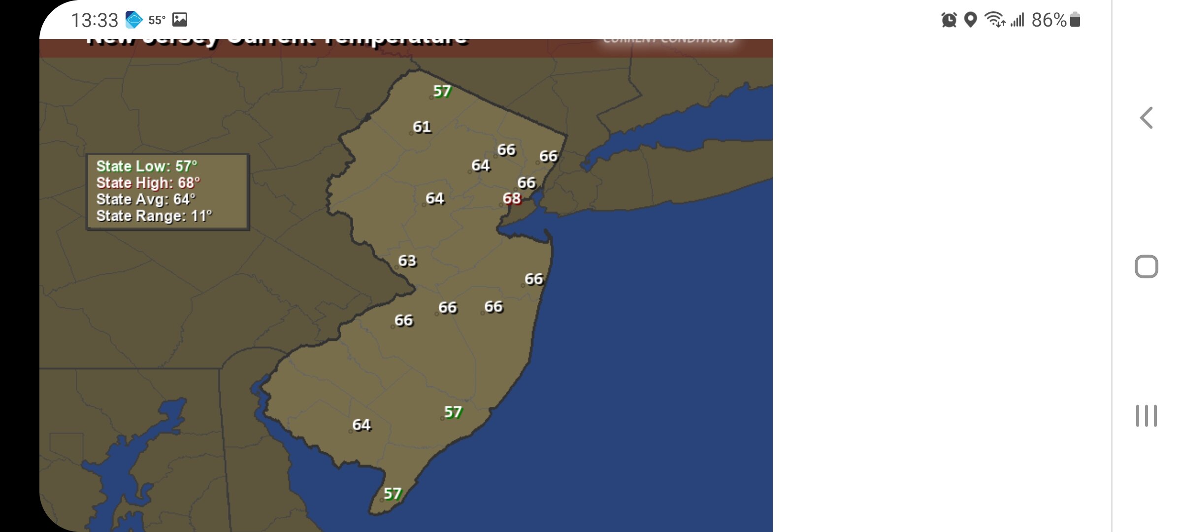
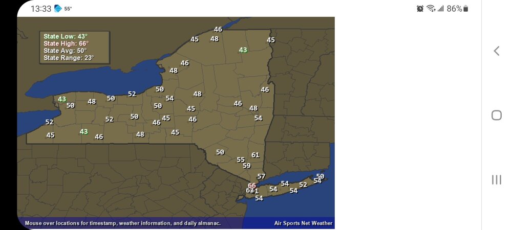
Such a large temperature range right now from 50 at Montauk to 66 at Central Park. Cold ocean waters hard at work.
-

-
Today's record highs for select few places. Central Park record high is 67 Islip record high is 68 Bridgeport record high is 65
-
55
-
Upton back peddled lga and nyc might tie records today lol
-
54
-
See, that's why I thinking snowman meant records broken possibly jersey south, at least with 50-80% chance of actually coming close if not breaking.
-
Btw, there's no option to change text size on stuff being posted other then bold, italic, and underline? Also max upload file size is only 1.5mb? Been forever since I been on here just quickly asking to refresh memory.
-
Ahead of the cold front, models are in good agreement with a strong llj (70-80kt@950mb) developing across eastern coastal areas late tonight into early Friday morning. As is typical for this time of year with water temps in the lower 40s, the challenge is how much of the llj will be able to mix down in a strongly inverted low-level environment. GFS/NAM have remained fairly consistent over the last 48 hrs, with GFS indicating a typically slightly deeper mixed layer, with potential for 50 kt gusts across LI/SE CT, while NAM more strongly inverted indicating gust potential of 40 kt. NBM has trended slightly upward with gust magnitude from 24 hrs ago, with 4.0 indicating 45-50kt gust potential for LI and SE CT, while version 4.1 continuing to showing a 45-55 kt potential for LI/CT. HRRR 10m wind gust potential, which has show to be skillful (albeit a little high) indicating potential for 55-60kt gusts for LI and SE CT as well. SPC HREF indicating high potential for 30kt sustained winds across LI/SE CT as well (not common), supporting the strong to damaging wind gust potential. Based on the model consistency and trends over the last few days, confidence is high in a strong wind (wind advisory) event tonight across the entire area, including NYC (45-55mph gusts), with moderate to high confidence in high winds gusts (55-65mph) for LI and SE CT under the core of the 75-80 kt llj. The timing for peak strong to high wind gusts continues to center around 6-12z Fri. Despite the strong inversion, based on the slight upward trend on NBM 4.0 wind gust guidance towards the stronger NBM 4.1 guidance, the strong signal from CAM guidance, and the anomalous strength of the llj, will upgrade to a high wind warning for all of LI and SE CT. Elsewhere will issue a wind advisory for strong wind gust potential ahead of and immediately behind the cold front, with highest threat along the coast and higher elevations.
-
I was just reading that, things trended back up over night, I guess that was too be expected. Lol
-
Possibly one logical reason and, I do get it/ understand it, to name storms would be for better identifying/remembering storms more easily versus simply dates. Also, if there's say 5 storms in a2 week period, that could easily get confusing when your throwing around months/ years and getting individual storms confused. Using the hurricane centers great success of people easily recalling past storms by name, maybe part of the reason they tried it. Idk
-
With multi quote, you can answer each of the quoted posts under that particular quote, if that makes sense.
-
Hrrr wind speed show some 40-50kts south of Long Island though.
-
At any rate the 10m speeds aren't very impressive as those I know at correct view.
-
Lol that makes way more sense haha
-
One of these things is not like the other lol
-
This is what it is showing 300 feet up btw. 60-112kts
-
At 10m, this is what euros saying. Translating to 50-55mphs models were suggesting 70-75 other day at 500ft or so. Again the NWS say the big winds are going be about 500ft up in eastern areas.
-
500 feet up to be exact. Yes I know. Again gfs is over doing like it usually does with big wind lol
-
Upton said wind threat has lessened. But there using nam gfs middle ground apparently
-
Gfs goes overboard mixing every time.