wthrmn654
-
Posts
3,069 -
Joined
-
Last visited
Content Type
Profiles
Blogs
Forums
American Weather
Media Demo
Store
Gallery
Everything posted by wthrmn654
-
86.5 with about a 71 dew point! The amount of sweat I've made already today!
-
I've always thought that the gladestone quality checking isn't really correct/ done the best in some occasions. For example, my nearest is usually the station at Grabreski , which temps etc can vary fairly drastically at times versus mine.
-
This wind reminding me i still need to readjust my station on roof, it's not aimed correctly still
-
There's deft a healthy breeze today, though temps are still climbing here on other fork.
-
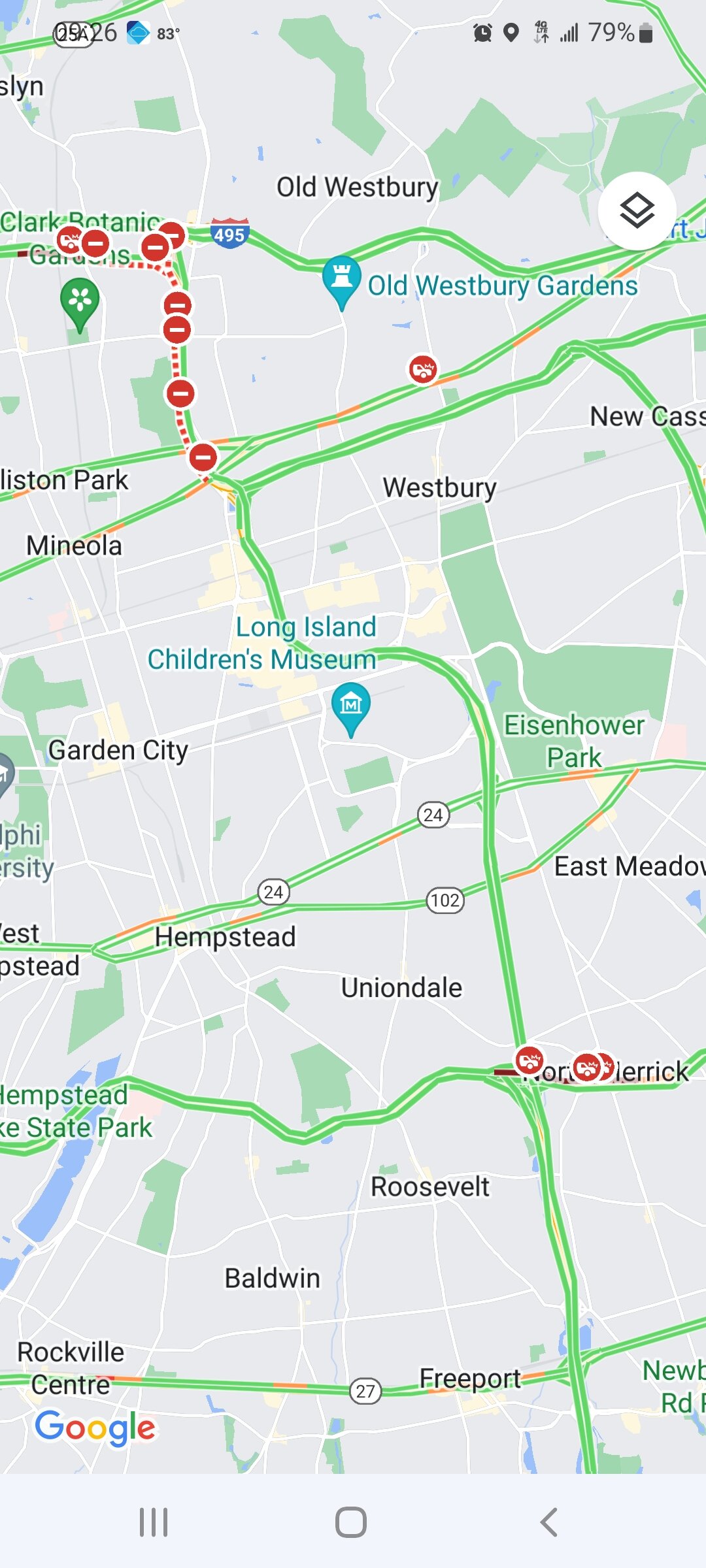
Already 10 outages affecting 210 people on the island.
-
Right, just seemed odd seeing that blob on the north shore. I'm assuming as well that's a blooper of sorts. Especially since riverhead, where it shows drought has seen nearly 4 inches of rain this month already lol
-
You know it's too hot out when there's not 1 but 2 car fires at literally the exact same time, one on the northern state, one on the southern state... and on either ends of the Meadowbrook parkway that connects the 2!... 1 in million odds
-
And bam just like that forecast high is 91 now
-
Forecast high is 86 for my area but it's already 82. Hmm well I beat that, time will tell!
-
I feel like that depiction out towards riverhead is incorrect, they had 2-3 inches of rain in the past week.
-
Here at the state park we're starting the day off at 77°F Humidity at 82% Dew point of 71.2°F Heat index 77.2
-
81 at 930 woof
-
Maxed out at 93 today down to 84
-
- Changed Discussion -- Forecast area will remain at the southern edge of the westerlies through the upcoming weak, which will allow for several frontal systems to impact the area. Additionally, temperatures this week will be mainly at or just above normal with the exception of Monday and Friday, where temperatures will be a bit warmer ahead of approaching cold fronts. There is uncertainty Monday with both temperatures and the magnitude/coverage of convection in the afternoon/evening hours as a pre-frontal trough triggers the majority of the convection. Model time-height cross sections indicate an abundance of mid and high level moisture (clouds) which would be a limiting factor for highs as well as how much the airmass destabilizes. For the time, have held off on extending the heat advisory into Monday, but the potential remains. SPC has maintained a Slight Risk for severe thunderstorms across the entire area Monday. The main threat being damaging winds associated with multicell clusters or line segments. Deep-layer shear does deepen through the day. The question is the amount of daytime heating/destabilization (extent of cloud cover) and whether the forcing with the pre-frontal trough will be deep enough to trigger convection. Mid-level lapse rates, as has been the case for most events this warm season, are around or just shy of 6C. So while not a slam dunk event (rarely are here), the ingredients are there for severe weather. In addition, the southward progression of the boundary will be slow, raising possible concerns for training of thunderstorms. WPC has the area under a Marginal Risk for Excessive Rainfall. High pressure builds in behind the cold front for Tue and Wed. A warm front is forecast to move through the area Wednesday night into Thursday, followed by a cold frontal passage Friday. Chances of showers and thunderstorms are in the forecast during this time. -- End Changed Discussion --
-
Tomorrow's record highs .CLIMATE... Record maximum temps are possible on Sunday 7/24. Below are the current records max temps. EWR- 99/2010 BDR- 95/2010 NYC- *97/2010 LGA- *98/2010 JFK- 97/2010 ISP- 96/2010 * ALSO OCCURRED IN PREVIOUS YEARS
-
Newark hit 100 at 210 pm
-
Name:New York City, Central Park Provider:ASOS/AWOS Valid:23 Jul 1:51 PM EDT Temp:93 °F
-
NEAR TERM /THROUGH TONIGHT/... -- Changed Discussion -- Forecast is on track with minor changes needed. Temperatures are currently in the lower to middle 90s. With dew points ranging from the middle 50s to lower 60s in many spots, heat index values are in the lower to middle 90s as well. Where dew points are higher (coastal Connecticut and south shore of Long Island) temperatures are cooler thanks to sea breeze development. Therefore, heat index values are similar to other locations in the forecast area.
-
92.8 Dewpoint dropped to 57, beautiful! 31%humidity Heat index is about 93°F
-
So far I've had 90 or higher may 31, then ebay, Friday and today 90 or higher. If I can score a 90 tomorrow I'll be heat waving!
-
They said criteria would be borderline and would leave the advisories as is.
-
Finally hit 90 but it stepped to 89 ish lol
-
11 am update .NEAR TERM /THROUGH TONIGHT/... -- Changed Discussion -- Forecast is on track. Temperatures were a degree or two warmer than previous forecast. Dew points are starting to mix out mainly across western Long Island, New York City, and northeast New Jersey. This should continue into the afternoon as dew points likely dip into the upper 50s, at least away from the southern coast of the city. In southern portions of the city, dew points should start increasing as sea breezes make their way through later this morning into the afternoon.
-
I believe the breeze has begun.
-
Just about 87 Humidity is 55% Dew point is 67.8 Heat index is 89.6°F