wthrmn654
-
Posts
3,069 -
Joined
-
Last visited
Content Type
Profiles
Blogs
Forums
American Weather
Media Demo
Store
Gallery
Everything posted by wthrmn654
-
89.2, almost got 90
-
-
-
-
https://www.npr.org/2022/08/03/1115378385/tonga-volcano-stratosphere-water-warming Tonga's volcano sent tons of water into the stratosphere. That could warm the Earth Earlier large volcanic eruptions have affected climate, but they usually cool temperatures, because they send light-scattering aerosols into the stratosphere. Those aerosols act as a sort of massive layer of sunscreen. But since water vapor traps heat, the Tongan eruption could temporarily raise temperatures a bit, the researchers said. It normally takes around 2-3 years for sulfate aerosols from volcanoes to fall out of the stratosphere. But the water from the Jan. 15 eruption could take 5-10 years to fully dissipate.
-
85 for today's high. Not to shabby
-
Suffolk Water Authority expands water emergency to 4 East End towns Suffolk County Water Authority officials have expanded water emergency conditions declared in Southampton Village to its customers in the entire town, along with Southold, East Hampton and Shelter Island. The declaration of a Stage 1 Water Emergency for those towns was made to ensure there is sufficient water for firefighting and other emergency purposes, Water Authority and municipal officials said at a Tuesday morning news conference. It comes just days after the state designated Long Island and more than 20 other counties to be on drought watch.
-
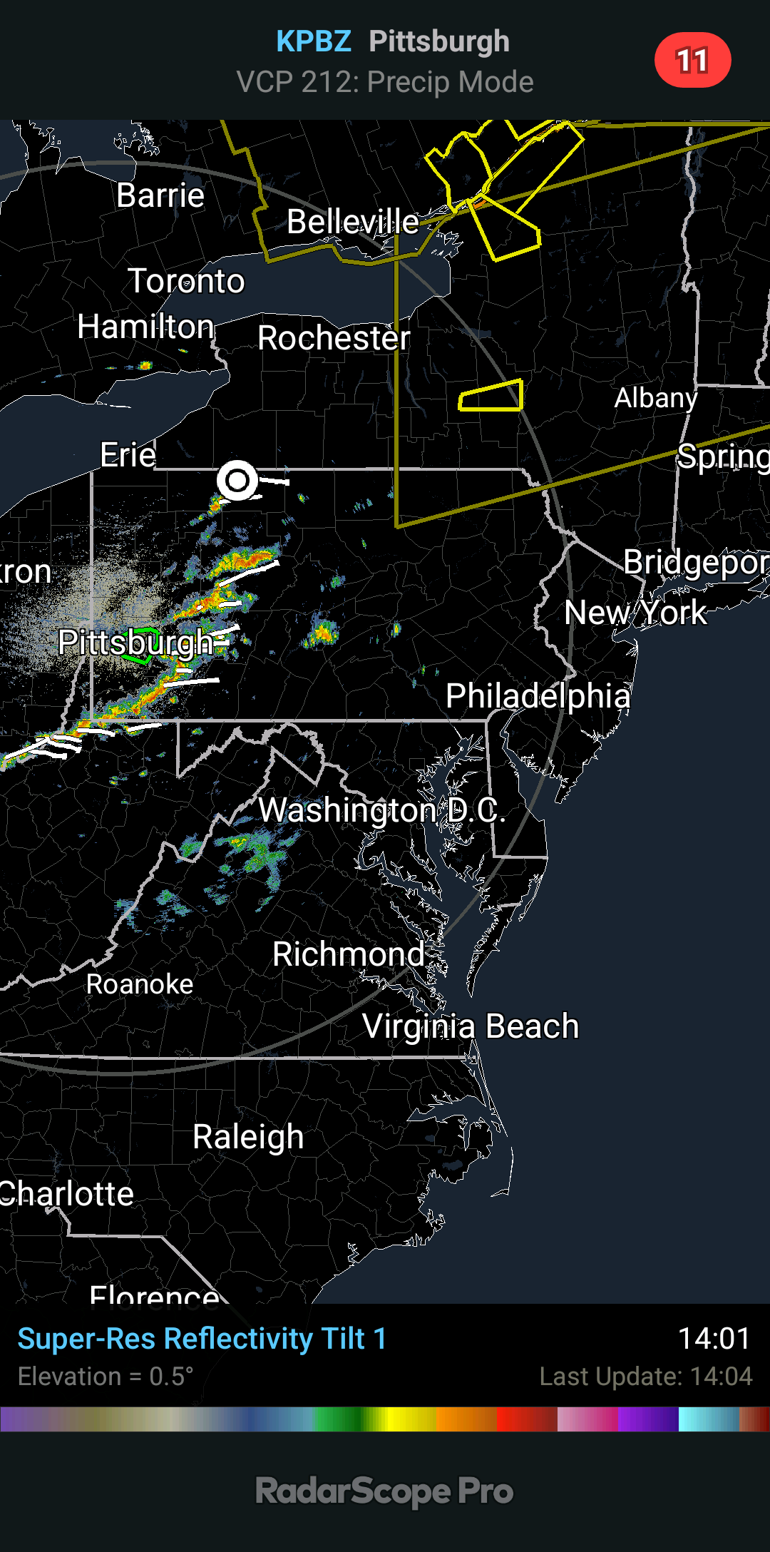
I got storms heading my way
-
CLIMATE... Thursday August 4 Record High/Year NYC 100/1944 BDR 93/1995 ISP 91/2006 LGA 99/1944 JFK 93/2006 EWR 100/1993
-
Interesting to see heat advisories issued for Thursday already.
-
Nws thinking we could see pulse wet microbursts Friday with current thinking.
-
0.26 I'll take it
-
It's the beginning of the end of the earth is what it means....
-
Jfk has been averaging out of range as well ironically.
-
I'm not really sure what to think, right now I think the stations fine. Especially since it's been nearly spot on to analysis, other then peak time of a summer day......
-
Also, has anyone tried contacting, [email protected] For issues with data quality, please contact the ASOS Operations Center
-
Jeez, looking at the days where the it hit 100, it shows the analysis station didn't even fully record those days...... how can that be reliable?! Heck the analysis station being used is rarely doing full days... .
-
Anyone know by chance how far back this temperature debate may extend to? Like many years, only a couple, since it was first installed, etc?
-
I'm not fully sure how to interpret this graph but it's the mean daytime analysis.. nighttime it's fairly fine ironically. When you do the day/ night comparison it drastically cuts the error down. But either way , the daytime error is pretty obvious. I wonder if anytime is reflecting light onto the sensor housing?
-
Though not always accurate, it essentially only showing it being about 1 degrees warmer during day and night. You would think it would be much higher.
-
Iwould love if Every summer day cool with a breeze but in the 80s like it is today
-
My God, gfs through August 12th has essentially no rain anywhere maybe 0.5-0.75 in a couple spots but otherwise it looks dry! Gefs doesn't look much better either ugh...
-
Looks like we have to hope this line holds strong on the march east!
-
NEAR TERM /THROUGH TONIGHT/... -- Changed Discussion -- An upper level low is slowly drifting south from Ontario toward the Great Lakes. The upper level flow out ahead of the low over our area remains mostly zonal, with weak energy passing through. At the surface, a warm front and any associated isolated showers had lifted just E of the CWA. Early to mid afternoon should remain mostly dry ahead of an approaching cold front. Showers and a few tstms entering western/central PA should moves east and expand in coverage/intensity, reaching western portions of the CWA between 21Z-22Z per 14Z HRRR which has fairly good handle on that activity over PA. Modest buoyancy (MLCAPE 1500-2000) and deep layer shear (35-40kt 0-6 km bulk shear) as this activity approaches will support the potential for a few strong to severe thunderstorms, with the primary threat damaging wind gusts. Expect two separate rounds of storms, one via the activity approaching from PA, another passing mainly across the interior this evening. Coverage looks to be scattered given H7 inversion to be overcome, possibly another developing this afternoon at H8-9 via daytime heating/WAA. SPC Day 1 Convective Outlook has the lower Hudson Valley and S CT under a slight risk of severe thunderstorms and the rest of the area in a marginal risk, but could see justification for including NE NJ and the NYC area in that as well. Highs will be in the mid 80s for most, with the NYC/NJ metro reaching the lower/mid 90s. This combined with dewpoints in the lower/mid 70s will allow for max apparent temperatures in the upper 90s. An isolated brief apparent temperature reading of 100 is possible in the NJ Turnpike corridor of NE NJ. With just one day of apparent temperatures at or above 95 and any 100 degree apparent temperature reading being very isolated, there continues to be no heat headlines after collaboration with neighboring offices. Winds become NW-W briefly behind the cold front and drier air briefly advects into the area. After midnight the entire area should be dry. Lows will be in the mid 60s farther north and west where the cold front will work through first. Across NYC/NJ metro area and Long Island lows will be in the low to mid 70s. -- End Changed Discussion --