wthrmn654
-
Posts
3,069 -
Joined
-
Last visited
Content Type
Profiles
Blogs
Forums
American Weather
Media Demo
Store
Gallery
Everything posted by wthrmn654
-

2024 Atlantic Hurricane Season
wthrmn654 replied to Stormchaserchuck1's topic in Tropical Headquarters
2 maybe 3 tropical systems showing up on more then 1 model in the next week or 2.. interesting times ahead, I was starting to doubt we could have such an active season with all the insane dust levels, but still time will only tell. -
-
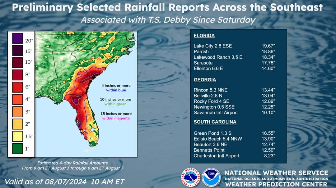
Observed totals.
-
Satellite estimates are up to 53knts. Up to the last recording which was... 1945utc
-
2024 Atlantic Hurricane Season
wthrmn654 replied to Stormchaserchuck1's topic in Tropical Headquarters
It's a system none of them are closer to shore... -
2024 Atlantic Hurricane Season
wthrmn654 replied to Stormchaserchuck1's topic in Tropical Headquarters
12zcmc has a tropical looking system up the coast too -
-
Looks like tracks are are shifting back east after it starts heading north again lol talk about back and forth... jeez.
-
forward speed increased by 1 mph
-
SUMMARY OF 1100 PM EDT...0300 UTC...INFORMATION ----------------------------------------------- LOCATION...31.1N 82.1W ABOUT 60 MI...95 KM NNW OF JACKSONVILLE FLORIDA ABOUT 35 MI...60 KM W OF BRUNSWICK GEORGIA MAXIMUM SUSTAINED WINDS...45 MPH...75 KM/H PRESENT MOVEMENT...NE OR 50 DEGREES AT 7 MPH...11 KM/H MINIMUM CENTRAL PRESSURE...997 MB...29.44 INCHES
-
-
-
-
The tropical cyclone should continue to weaken while it moves over land for the next day or so. By late Tuesday, assuming the center of the system moves back over water, some re-intensification is forecast. The NHC forecast continues to show only modest restrengthening due to the uncertainties, although this may be conservative.
-
-
What in tarnation is this mess?!
-
Euro track, depending how beaten up Debby is, potentially has it strengthing again south of Long Island on its way northeast
-
-
shes growing in size suddenly!
-
there no doubt about it now there deft is a easterly movement.
-
once it did that east jog it looks to have a north east motion now.