wthrmn654
-
Posts
3,069 -
Joined
-
Last visited
Content Type
Profiles
Blogs
Forums
American Weather
Media Demo
Store
Gallery
Everything posted by wthrmn654
-
Years ago I thought there was a saying about one of the letters in the alphabet of names being one that's not good with tropical systems. Lol it may of been the letter E storms None the less, Ernesto tropical career has been one that was never really successful only 2 times if i remember the wiki Stat from yesterday,did it became a cane.
-
-
I swear it looks like that front is taking it north east faster..
-
It picked up 1 mph sped Movement wise lol
-
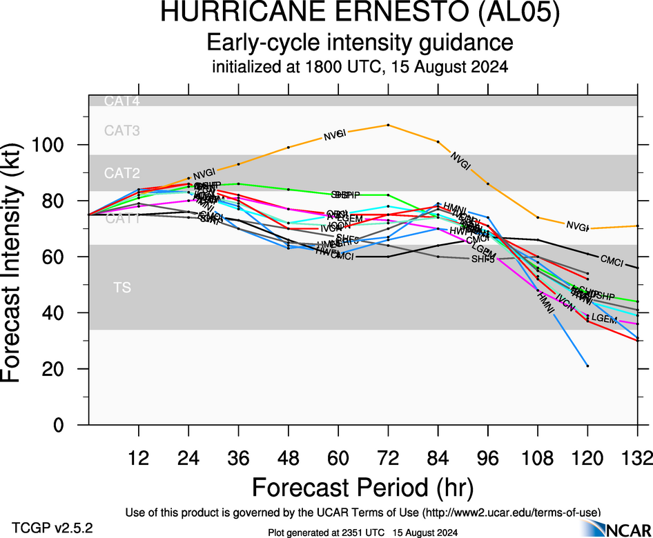
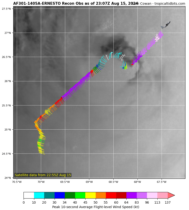
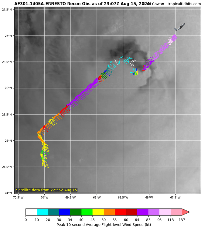
NWS National Hurricane Center Miami FL AL052024 1100 PM AST Thu Aug 15 2024 Ernesto has been strengthening this evening. Data from an Air Force Hurricane Hunter aircraft indicate that the minimum pressure has fallen to about 968 mb, and a blend of the peak flight-level and SFMR winds support increasing the initial intensity to 85 kt. This makes Ernesto a category 2 hurricane on the Saffir-Simpson Hurricane Wind Scale. Ernesto has a ragged eye and a large wind field, with the highest winds occurring in the northeast quadrant. Ernesto is moving north-northeastward at 12 kt in the flow between a high pressure system over the central Atlantic and a large-scale trough off the U.S. east coast. This general motion is expected to continue for the next day or two, bringing the hurricane near or over Bermuda on Saturday. Around that time, the trough is expected to lift out, leaving Ernesto in weaker steering currents. As a result, a slower and likely more erratic motion to the north or north-northeast is forecast over the weekend. Another trough is expected to approach the cyclone late in the weekend, and that should cause an accelerated motion to the northeast near or east of Atlantic Canada early next week. The NHC track forecast is a touch to the east and a little slower than the previous one through its passage near Bermuda to come into better agreement with the latest consensus aids. It seems likely that Ernesto will strengthen some more during the next 12 to 24 hours as it is expected to remain in conducive environmental conditions of low wind shear, upper-level diffluence, a relatively moist airmass, and over warm waters during that time. Thereafter, increasing vertical wind shear and gradually cooler waters should cause a slow weakening trend. However, baroclinic influences could offset some of the weakening, which is why the official forecast shows little change in strength during the 48- to 72-hour time frame. Ernesto is forecast to complete extratropical transition by day 5, when it will likely be embedded within the mid-latitude westerlies. The NHC intensity forecast lies near the high end of the guidance, in best agreement with the HCCA model.
-
I saw that as well, they were flying into a deep explosive cluster of storms when that was being recorded too
-
-
Amazing how it's still dropping pressure yet taking on air, but luckily winds aren't going crazy power say. With that said recon may of gotten a couple samples while it was firing up again. May just be night time throwing a twist but it looks like it's a little smaller.?
-

-
8 pm update 90 mph.
-
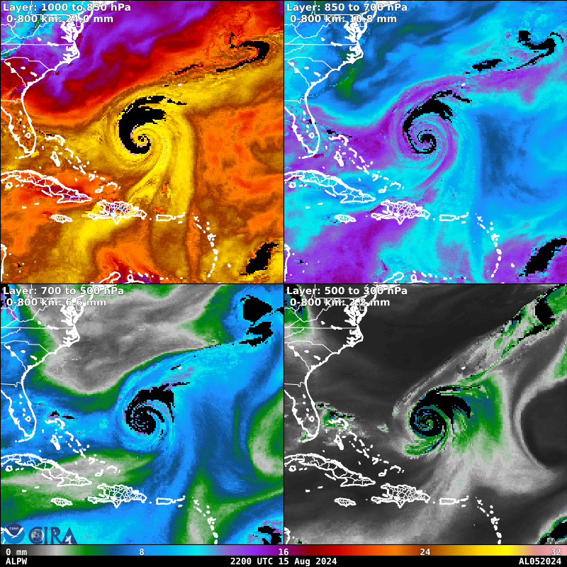
The lack of lightening around the center on sat tracking is just weird. Usually there's tons of thunderstorms around a good center. Found a Advected Layer Precipitable Water map.

-
I'm not sure, sat loops have been al over the place and I think that's a bit of the dry air and attempt maybe? Hard to say.
-
-
Pressure matches the average mslp for a category 2 hurricane, which has winds of 96mph or higher, yet the winds are still not matching yet.. and are still sub par with only about 71-75 knots to the east of eye area.
-
-
968mb Could be rough looking but being better ish?
-
972.9mb recon pressure?
-
Big big looking slug of dry air getting wrapped in south west side now, I do believe. Closest to the center. Quite ragged looking, imo
-
EDIT: just checking the better sat map, deft more dry air about to get wrapped in from the west side
-
i mean i give this little guy credit, i think its trying to make an eye.. and it just about has absorbed the dry air from today but it would seem, depending what mode you select, that the left side might have another round of dry air starting to get wrapped into it again. seems there's 2 rotations in the clouds surrounding him.. inner spinning counterclockwise with the surrounding spinning clockwise.
-
pretty impressive, the microwave loop brought the winds up to 75knots and has not moved up or down for a several hours...
-
A lot of grey areas and to many unknowns Imo for the intensity forecasts to materialize as right now that dry air will not let go and has been super consistent... Hurricane Ernesto Discussion Number 17 NWS National Hurricane Center Miami FL AL052024 500 PM AST Thu Aug 15 2024 The inner core of Ernesto continues to be plagued by dry air intrusion. A NOAA Hurricane Hunter aircraft reported that Ernesto has yet to close off an eyewall. While the minimum central sea level pressure has fallen to an estimated 972 mb based on dropsonde data, the maximum flight-level winds are still at 86 kt, similar to the earlier mission. Therefore, the initial intensity is held at 75 kt for this advisory cycle. Warm waters and relatively low vertical wind shear should allow Ernesto to gradually intensify over the next 12 hours or so. Still, the mid-level atmospheric moisture is expected to be marginal and the system could continue to experience dry air intrusions. Global models suggest that while the vertical wind shear could begin to increase within a day, Ernesto may be positioned in a region relative to the departing trough where it could capitalize on enhanced outflow and continue to strength. By the weekend, atmospheric conditions should become less favorable and gradually weaken the hurricane. Still, Ernesto is expected to remain a powerful hurricane as it moves north of Bermuda. Little changes have been made to the latest NHC intensity forecast, which lies near the top of the model guidance envelope.
-
a little fun and games but historically speaking, ernesto has never materialized to much usually lol Ernesto 1982 – formed southwest of Bermuda and dissipated without threatening land. 1988 – formed east of Bermuda and did not cause any damage or casualties. 1994 – formed southwest of Cape Verde and dissipated without affecting land. 2000 – lasted for two days and did not threaten land. 2006 – a Category 1 hurricane which formed near the Windward Islands, made landfall in Haiti and Cuba, struck Florida and the Carolinas, and killed at least 11 people. 2012 – a Category 2 hurricane which made landfall in Mexico. 2018 – formed in the North Atlantic and dissipated without affecting land. 2024 – currently active.
-
-
unless I'm mistaken its northwest side just started interacting with the front? the clouds that were wrapping around all but vanished as soon as it touched it. that and looks like it just ran into some more decent dry air....