

Baum
-
Posts
4,523 -
Joined
-
Last visited
Content Type
Profiles
Blogs
Forums
American Weather
Media Demo
Store
Gallery
Everything posted by Baum
-
What a world. We debate how someone should be classified in death, and just point fingers as to who's to blame versus pulling together and hoping this ends sooner rather than later and with less pain and sorrow for our fellow people. We really need a lot of folks to reexamine what's important starting with turning off your local and national news media outlets, and twitter pundits and focus on friends,family, and community. Bottom line, whether it's the virus itself or the residual damage we are all in for a very tough time. Time to take stock of what's important.
-
Alot more discussion on the after affects and the economy today which is interesting. I saw this as a retweet on twitter, and I'll assume it is accurate which would be a positive: The @IHME_UW model vs reality for New York State, April 5. The model is less accurate than ever. 69K beds projected, 16.5K actually needed; 12,346 ICU beds projected, 4376 needed. Even better (tho not for the model), overall bed count rose less than 600 statewide - less than 4%.
-
I could see someone just getting out in the car and blasting The Clash or Luke Bryan just to blow off some steam ....or The Cars.....
-
While I can't predict the eventual fall out from this, and the debate that will rage after the fact, in my area I'm not seeing the idea that people aren't doing what's necessary. Take a look at the unemployment rate, closed businesses, sports shut down and so on.....strangely public transportation still operates. And as I said yesterday, my local grocer is pretty much vacant, and people stay well away from anyone. You'd think in a hot spot like your area this would be the same. Truth be, folks look scared shitless...
-
Has anybody heard how Japan is doing and what type of lock downs they have in place?
-
Thank you for a clear cut understanding of the difference. Much appreciated.
-
thank you.
-
But wouldn't the same concerns exist in the H1N1 pandemic? Also, is there a site that shows actual hospital bed availability as this virus continues to ramp up?
-
you seem very knowledgeable on this stuff. Can you provide the reason for the mass shutdowns and government intervention in this pandemic vs the H1N1 pandemic about a decade ago? I've chalked it up to the rapid spread and the unknowing factor of exactly what we are dealing with. But would love a more professional bend on the issue. Thanks.
-
I'm not a blame guy in times of crisis. The Chinese Government thing is an altogether different animal which will have to play out.
-
I was at my local food store. Not many people at all. Most stay far away or head to a different aisle -common sense being applied which is very refreshing. Very concerned given the current projections what the next two weeks will bring. Has anybody seen that video of Dr. Fauci stating in mid-January that the U.S. has nothing to worry about? Eye opening to say the least.
-
That projected number of 100,000-240,000 deaths Dr. Fauci has been warning is a scary number...though I guess it's not as bad as some of the earlier forecasts of a more than a million. And obviously, the socio-economic impact will take months to filter through. My understanding is 50% of our countries deaths have occurred in NY and the fatality rate has crept up to near 2.5% which is also concerning.
-
do they project 100,000-240,000 we are currently expecting?
-
^ or not.
-
Son got furloughed today. Wife who is a parochial school teacher has to take a 33 1/3 % pay cut .
-
It's real life, and sometimes it best to be patient and watch. And no, it's not a movie..........yet.
-
-
This is extremely sad, but a story that needs to be followed up on due to it's obvious ramifications: “There has never before been a death associated with COVID-19 in an infant. A full investigation is underway to determine the cause of death,” said IDPH Director Dr. Ngozi Ezike. “We must do everything we can to prevent the spread of this deadly virus. If not to protect ourselves, but to protect those around us.
-
How in the world did we inject Bastardi into this thread?
-
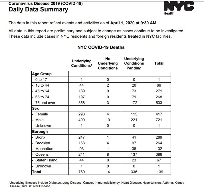
The time to assign blame accomplishes zero during a time of crisis. There will be time to assess and apply where we failed, where we succeeded, and what preparations, and actions need to be taken going forward at a later date. The blame game is a losers game. And sadly, and lastly any posting of death stats needs to include avg. age./region/ death rate/ any underlying circumstances/ and recovery rates. There is still much unknown regarding this virus, and those stats are extremely telling to paint a real picture. Let's all hope we can work together ,limit the damage for everyone's sake and get back to a normal circumstance sooner rather than later -all the wiser for it.
-
agreed.
-
-
I'm the grandpa.
-
and I was going to have pancakes and bacon this morning for the first time in years as a treat vs. my spinach and avocado smoothie...dam it! Thanks for that...note...i was going to add blueberries to the wheat cakes.
-
Thanks, I also came across the John Hopkins site.


