.jpeg.a4efd145a186e96890004342214cde5f.jpeg)
Baum
-
Posts
4,163 -
Joined
-
Last visited
Content Type
Profiles
Blogs
Forums
American Weather
Media Demo
Store
Gallery
Everything posted by Baum
-
^ beyond the heavier snow i reported earlier which was brief you'd have to argue the bonus snows on the arctic front have been a bit of a let down to this point.
-
pouring flakeage. First real powdery flakes of the year I suspect. Probably at 3"...going to need a good hour or two of decent rates to get too my call.
-
might not be a bad thing to get rid of today's 3-4" and wash off the salt residue before the warm up. Funny thing, now I see LOT only has upper 20's for highs next Wednesday. Dealayed, not denied I suspect.
-
my 6-10" er lurks..........
-
no, that's Rochelle. Best looking radar event of the season...how does it not phase?
-
how long do you expect the intial waa band to hang on?
-
bit ahead of schedule...maybe we can get some overperformance in Warm advection wing........
-
^ Squeaky wheel gets the grease...kevlon is ground zero...
-
i'm model hugging the euro....
-
revised call 4.7"
-
maybe the best radar signature we've seen on an incoming event all winter.....
-
I'm the wrong guy to ask regarding this. I'm guessing some of the other Chicago area posters can weigh in on your behalf....I will say if your in lake county forecast is for mid -late evening start.... edit: Cook and Dupage now in WWA.
-
it seems the immediate Chicago metro is working itself back to the 3-4" totals that looked reasonable before yesterday's 12Z runs. Shame, would have been a nice storm if a phase had occurred.
-
you know it's been a tough winter when the snow thread turns toward the glory of lengthening daylight..
-
^ could be looking at 2019/ 2020 winter's peak over the next 36 hours.......................................................................................................
-
revised call 2.9"
-
so what happend to it?
-
revised call: 4.8" "STEEPENING LOW-LEVEL LAPSE RATES AND A DEEPENING DENDRITIC GROWTH ZONE (DGZ) IN THE WAKE OF THIS FRONT WILL ALSO SUPPORT BETTER SNOW-TO-LIQUID RATIOS UP AROUND 15-16 TO 1. FOR THIS REASON, ADDITIONAL ACCUMULATIONS OF 1 TO 3 INCHES (ISOLATED HIGHER) ARE POSSIBLE ACROSS MUCH OF THE AREA LATE WEDNESDAY NIGHT INTO THURSDAY MORNING. THIS COULD REQUIRE THE NEED TO EXPAND THE CURRENT WINTER WEATHER ADVISORY NORTHWARD TO INCLUDE MUCH OF THE CHICAGO METRO AREA WEDNESDAY NIGHT AND THURSDAY, " LOT PM AFD
-
I don't do RAP.
-
Here is an optimistic take; were due for a decent spread the wealth system that covers a large area with colder winter temperatures. If it falters, as has been the case in recent times, I avoid the crap all over my shoes and garage area, and can hopefully look forward to an early spring. Even today, the longer days provide harbinger of good times ahead. Heck, spring training begins this week.
-
5.0" call MBY
-
don't disagree with the sharp gradient on the NW edge;"LOWER CONFIDENCE IN FAR NORTH/NORTHWEST CWA WHERE LESS FAVORABLE SYNOPTIC EVOLUTION COULD YIELD AFOREMENTIONED SHARPER CUT-OFF IN PRECIP SHIELD.," as LOT alludes too. But fairly solid 3-5" totals thorugh a good chunk of the metro. Ratio's should help. Areas south and east may get the bonus qpf, but with lower ratios.
-
CONFIDENCE IS INCREASING IN A LONG DURATION ACCUMULATING SNOW EVENT FOR THE CWA STARTING WEDNESDAY AFTERNOON AND ENDING DURING THE DAY ON THURSDAY. THERE IS NOW BETTER OPERATIONAL AND ENSEMBLE AGREEMENT IN THE MID AND UPPER LEVEL PATTERN EVOLUTION.....RC/LOT
-
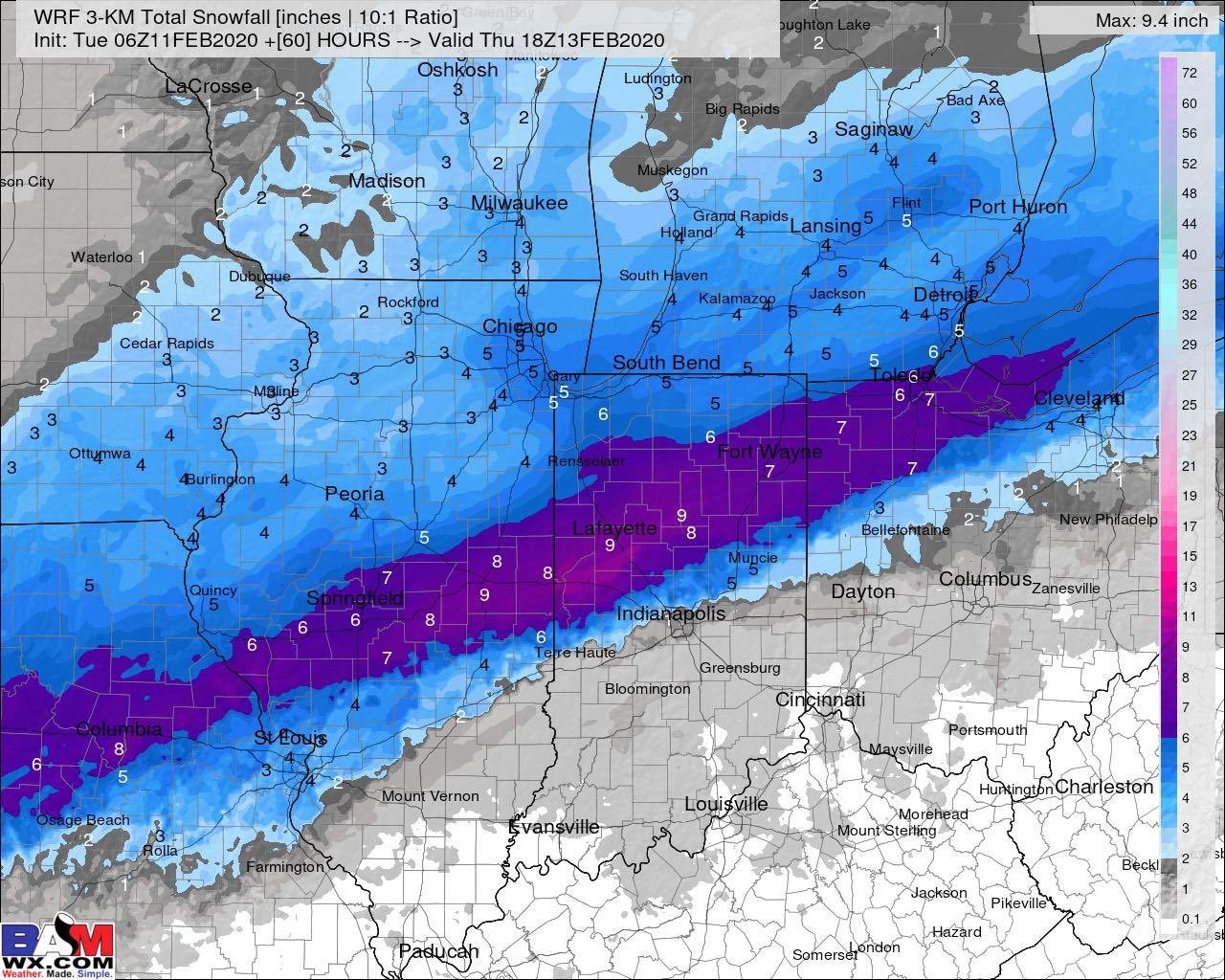
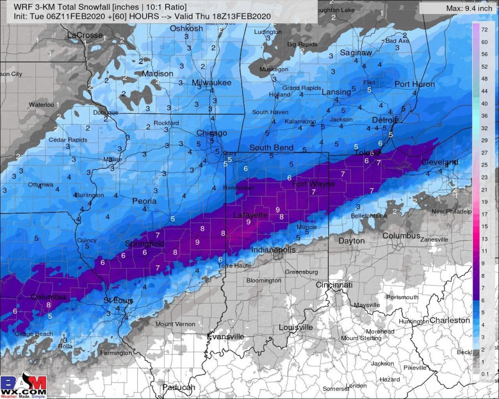
no euro kuchera map? bummer........
-
it would only make sense that the model that was most consistent showing an event would jump ship once a few other models got on board....
.thumb.jpeg.e8e3bdfcc29eb766d3b1add909fceea2.jpeg)