

GramaxRefugee
-
Posts
1,547 -
Joined
-
Last visited
Content Type
Profiles
Blogs
Forums
American Weather
Media Demo
Store
Gallery
Everything posted by GramaxRefugee
-
Low 74 this a.m. (High yesterday 94)
-
Bit less humid today, DP 75 not 81. High 95f. Lot of PM clouds improving comfort, but no rain.
-
Low of 78. My highest min since several years. Was 82 at midnight.
-
Ok, I had to look....RDU claims 106 max. You're right; it looks suspicious. Most surrounding stations peaked mid 90s, one hit 99. Plus, RDU numbers oddly up and down. Says they had a t-storm; maybe that had something to do with it. RDU used to be mostly reliable. 96 high for me today, but DP hit 82. Pluh!
-
Only 0.03 here, in several humid showers.
-
85/75 under overcast. Was getting somewhat oppressive before the clouds moved in
-
I looked at my NWS location and it forecasts high of 90, and Heat Advisory. Oh? We issue HA for 90f now? I clicked inside the Beltway and got it up to 93. Still pretty pathetic. Maybe we'll bust over. 76/67 here
-
Low 59, very clear
-
Wow... Storybook. Misery for the opposing pitcher though.
-
My June total 1.69" Highest temp 95, lowest 53
-
Quite interesting. The behavior of the landscape lighting circuit is similar to that of a dog radio fence, (Invisible Fence- which uses a buried wire), that my friend had take a lightening hit years ago. Followed the wire and blew the transformer. Glad your losses were minimized at least.
-
Foolishly high DP of 80 here. 90f and I wouldn't be surprised if that's the high. Significant clouds time-to-time
-
0.02" overnight
-
Hi of 88f, but plenty steamy DP 77 Current 81/77
-
0.30" overnight About 1.5+" for June so far.
-
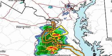
Well spotted @vastateofmind Checked radar and was surprised it held together:
-
The batch that we do have is tracking toward the classic Potomac RIver - to - LaPlata tornado alley. The dew point up-and-down (and more down) measurements in the area weaken my confidence in anything holding together.
-
Noontime walk report near Annapolis: Summer has returned. DP at KNAK up to 76. It was breezy at least.
-
High 88, from morning low 59
-
Downright cool, low of 59 and dry. Calm for the moment. Midnight low for yesterday 68 I think.
-
Hi of 85 today. DP fell to 56 , shockingly low for my station.
-
Oh boy, we now have an exact date for a big cool-down coming. (More accurate than the Euro, anyway)
- 1,696 replies
-
- 2
-

-

-
- severe
- thunderstorms
- (and 5 more)
-
87/74 at 10:30 Low of 77 this morning
-
94/75 which is my high so far. Just went to Crofton and back. Strangely breezy.
-
I think there's a rule against questioning any weatherman who posts such a good Heat Miser picture. I figure Mr. Tony P carries it around in his wallet. Sort of related to the ref's red card.