

Ericjcrash
-
Posts
5,529 -
Joined
-
Last visited
Content Type
Profiles
Blogs
Forums
American Weather
Media Demo
Store
Gallery
Posts posted by Ericjcrash
-
-
To my surprise I woke up to about an inch of paste. I'll take it
-
 2
2
-
-
40 minutes ago, wolfie09 said:
GFS is actually pretty funny..Like Dave said, barely ever works out lol
.thumb.png.adc83cf0d6d78db0f98195e494f8c832.png)
Never.
-
1
-
-
4 minutes ago, TugHillMatt said:
You know we're entering Cutter-land when several days in the forecast are now predicted to have 40s and 50s for highs, there are wind advisories, and Buffalo and the Tug are excited for backside snows...
Hold my beer as I depart Dustingville to Cutter Island
-
 4
4
-
-
On dusting repeat here. 4 today.
-
2
-
-
Flurries all day, getting a little coating now as the sun is lower but super light stuff. Incredibly noisy on the leaves as the previous coating is all but gone.
-
1 hour ago, Buffalo Bumble said:
Figured it would have lost it with the next run but there it is again. That first run was the kind of evolution you sketch out on paper as the “dream” storm for BUF-SYR. Bombing low in Delaware Bay that moves N/NW to near Ottawa. Still too far out to get excited but makes the next few model runs interesting.
Yeah, everyone would be happy with that solution.
-
18Z GFS is spicy IMBY Monday.
-
1
-
-
1 hour ago, wolfie09 said:
Rgem fwiw.
Has some stronger bands embedded in the W/NW flow..
.gif.e994f36a34cdfe3e86d8d2c7582978d1.gif)
Glad I'll be in the city. Would be a painful radar to watch verbatim.
-
1
-
-
Defintely more T-snow incoming just south of Oswego. Dang.
-
1
-
-
2 minutes ago, CNY_WX said:
Not sure what you’re talking about. I’ve had a pretty healthy band over me for the last half hour. Closing in on an inch already.
I had moderate flurries for a few min before. I'm jealous.
-
1
-
-
2 hours ago, BuffaloWeather said:
Really good EPS track for central NY

That gets me moist.
-
1
-
-
Mangled flake and rain mix here.
-
10 minutes ago, MJO812 said:
I'm currently looking for a house similar to this in NYC. 700k plus here. Check out how much it is in Lowville , NY ( Tug Hill )
So much land. Not fair at all lol

4200 square ft in NYC would be $2M+ 6+ acres impossible and would be many many many millions.
-
2
-
-
1 hour ago, BuffaloWeather said:
RGEM actually 1-2 degrees cooler

Not often Richmond is significantly colder than Saranac lake.
-
1 hour ago, SouthBuffaloSteve said:
BUF updated AFD:
Friday night and Saturday the vertically stacked low will gradually
push eastward with its axis reaching western Quebec and western New
England by early Saturday evening. Its approach will bring in cooler
air aloft, enough so to produce lake effect precipitation. Consensus
850mb temperatures drop to -5c across Lake Erie by 12Z Saturday. SSW
flow will direct most of the lake effect rain showers across Canada
and far eastern portions of Niagara and Erie counties Friday night.
A few rain or snow showers are possible across the rest of Western
New York, but any of these would be on the light side.

Fairly good model agreement that the stacked low and a strong
embedded shortwave will move across the area on Saturday. This will
provide moisture which will enhance lake effect precipitation, and
will also produce rain or snow showers further inland from the lakes
due to the shortwave. Flow will shift to the southwest which will
direct what should be a well developed band across the Buffalo metro
area on Saturday. Still a bit too warm aloft to support lake effect
snow, although wet snow or graupel could mix in times. Also added a
mention of thunder with this band. A less developed band will
develop off Lake Ontario and move across the St Lawrence and then
Jefferson County. Further inland it won`t have to be quite as cold
aloft to support snow, with rain or snow showers possible with the
shortwave. Any accumulation would be minimal with high temperatures
in the lower to mid 40s.

Models suggest winds will shift to the WSW Saturday night in the
wake of the shortwave. Precipitation will once again become mostly
lake effect, with bands likely to be centered across southern Erie
county and across the Tug Hill. Slightly cooler 850mb temps around
-6c could support some snow accumulation, especially across higher
terrain. Fairly high confidence there will be lake effect bands, but
low confidence in precipitation type due to the marginal
temperatures.

&&

.LONG TERM /SUNDAY THROUGH WEDNESDAY/...
Bands of lake effect precipitation will start this period, with a
predominately southwest flow across the Eastern Great Lakes. This
will highlight precipitation along the Lake Erie shoreline, and
inland across the northern Niagara Frontier, as well as towards the
northern Tug Hill Sunday. Thermal profiles are marginal for snow,
with 850 hPa temperatures around -5 to -7C at periods start.

A shortwave from the northern Rockies will sharpen the east coast
mid level trough Sunday night and into Monday. Backing surface winds
will send lake precipitation northward...possibly entirely into
Canada by Monday morning, while all along more widespread synoptic
precipitation spreads over the region with the approaching
shortwave. Again thermal profiles are marginal for snow on
Monday...and not until the shortwave passes and flow becomes more
northwesterly later Monday and into Tuesday that temperatures aloft
will cool sufficiently for snow to be the predominate precipitation
type. By this time, the lake effect event will be winding down.
Sounds a lot like Oct 2006 if you ask me.
-
I have flaked as well.
-
1
-
-
3 hours ago, wolfie09 said:
Flipped to predominantly wet snow here, still sounds like some rain mixing in, temp down to 33°..

Wake up, I need to know if you're buried.
-
7 minutes ago, wolfie09 said:
Hrrr has the smallest band here tomorrow afternoon lol Actually under the band it's 33°-35° surrounded by low-mid 40s..
.thumb.png.c507361b56f9a2c77a322dddcab65a85.png)
Congrats maybe?
-
1
-
-
2 minutes ago, BuffaloWeather said:
I saw this on another sub-forum, think this is in Alaska. 250" in 2 days.
Detailed Forecast
TodaySnow. The snow could be heavy at times. Areas of blowing snow. High near 24. Southeast wind 65 to 70 mph increasing to 75 to 80 mph in the afternoon. Winds could gust as high as 85 mph. Chance of precipitation is 100%. Total daytime snow accumulation of 52 to 58 inches possible.TonightSnow. The snow could be heavy at times. Low around 23. East wind 50 to 60 mph, with gusts as high as 65 mph. Chance of precipitation is 100%. New snow accumulation of 110 to 116 inches possible.SundaySnow. The snow could be heavy at times. High near 25. East wind 40 to 50 mph, with gusts as high as 60 mph. Chance of precipitation is 100%. New snow accumulation of 73 to 79 inches possibleI feel the wind may knock down ratios a bit...
-
1
-
2
-
-
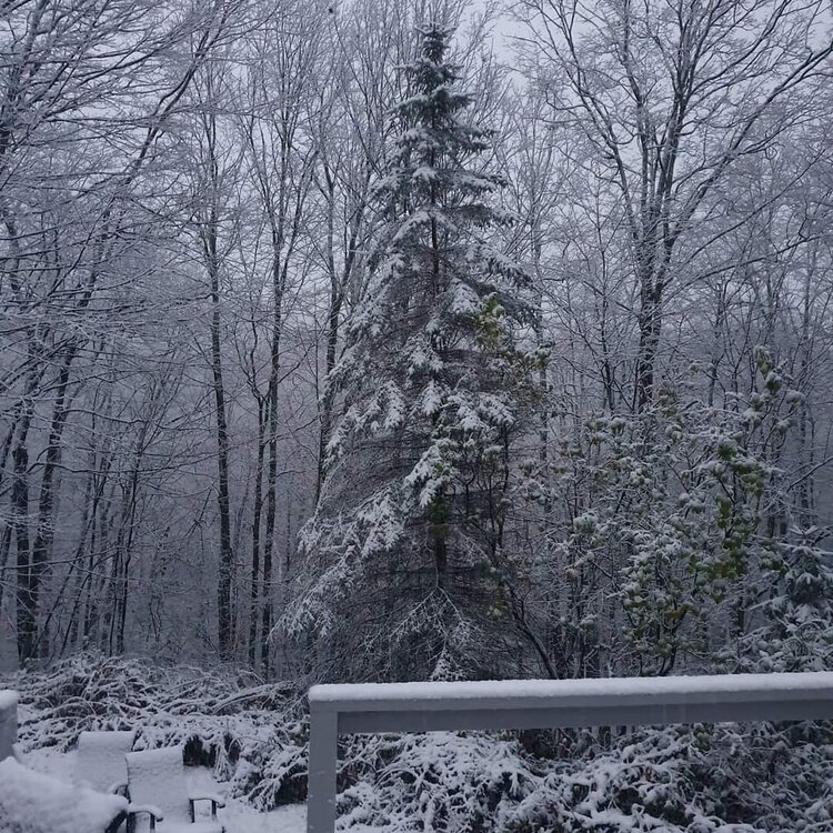
A year ago in Delaware County.


-
3
-
-
1 hour ago, wolfie09 said:
Not a bad place this far out. Euro on it's own though everything else is super squashed.
-
3
-
-
9 hours ago, wolfie09 said:
First wording of "snow" in the forecast..
Obviously would be early morning with a forecast low of 35°, maybe a mangled flake lol Either way a long shot at this point..
ThursdayA chance of rain and snow showers. Mostly cloudy, with a high near 46. Chance of precipitation is 40%.Same.
Tuesday NightA chance of rain showers, mixing with snow after 1am, then gradually ending. Mostly cloudy, with a low around 34. Chance of precipitation is 30%.-
1
-
-
31 minutes ago, SouthBuffaloSteve said:
Looks like it frosted across most of Erie County except on the KBUF property... Come on man! Somethings wrong here!

It's got to be all the pavement. Only thing that makes sense.
-
3
-
-
.png.6fdab0e5e99f125f41f7282bada16a35.png)

.png.5d2b936b48c21950619731ad436dd2b3.png)

 Lock it in
 .png.fec971ca9e62f0f40ceb0ad887e5416f.png)
Upstate/Eastern New York-Into Winter!
in Upstate New York/Pennsylvania
Posted
Canadian came through with the goods for next week. Will it verify? No.