NittanyWx
-
Posts
758 -
Joined
-
Last visited
Content Type
Profiles
Blogs
Forums
American Weather
Media Demo
Store
Gallery
Everything posted by NittanyWx
-
For what it's worth, these models have no real E Canadian HP signal until very briefly around the 5th. So if we were to get any storm ahead of that, regardless if it's a lake cutter or not, you'd have a big issue with cold air supply. If you were to get some energy out of the southern stream around then while that high is retreating, there's a small potential window around than Jan 4-6. As noted, however, I tend to think in regimes like this where h5 is favorable but source air is not, risk is HP/cold air associated with it gets overdone extended range.
-
The NAO difference is actually fairly marginal. Synoptically most have a piece of the PV near or just north of the Davis Strait. There's no real Atlantic block of note in the traditional sense, just heights building Iceland/E of Greenland which is of little significance to us.
-
The IOD seasonal collapse is consistent with past years. Even high amplitude IOD patterns collapse by the New Year almost without fail. So, in time, the jet will retract and there will be a retrograding PNA area ridge setting up. At that point with PV consolidation you'd hope that some form of wave breaking can perturb the PV and displace it towards this side of the pole for deeper into January to at least provide some chill to tap into and perhaps start building some snowpack in Canada in due time. Until that source is resolved how I view these setups for snow: HP/cold will likely be overdone on modeling without a true snowpack build in the extended range. So, generally, less is more when it'll come to coastals if/until this source airmass problem is resolved. Deepening coastals will likely be primarily rain producers where overrunning events or even clippers have the better potential to deliver wintery results.
-
Just a note that the GFS Ens has been posting higher skill scores in the 6-10 at 2m and suspect the EC Ens surface reflections will end up a couple degrees too cold. Sadly even the GFS Op has had less of a cold bias past 3 weeks. That said, do believe the base state is changing from December. Not a great source region still, but not as dire as late Dec.
-
Ok, get what you're saying now. Only reason I'm kinda hammering on this tropical forcing vs model T2m point is because I think it was a situation, and clear a clear one at that, that we can learn from as forecasters and apply to future predictions. Multi-faceted signal that - even in a situation where tropics were underamped - the model was still able to lead you to a place where you'd be happy going warm to very warm week 3/4.
-
You do follow Joe. I know because he tweeted almost verbatim what you wrote. I do not follow Greta Thunberg because she isn't a forecaster or really relevant at all to what I do.
-
You're ascribing PV displacement to what? Just the tropics? Because I vehemently disagree with that idea if you are. You've got 3 of the factors covered, but saying 'MJO inherent biases' is still a misread on the situation. Because the 'MJO inherent biases' were part of that weekly EC ens first week of Dec...and the model still went torch...and we still ended up in a torch nationally.
-
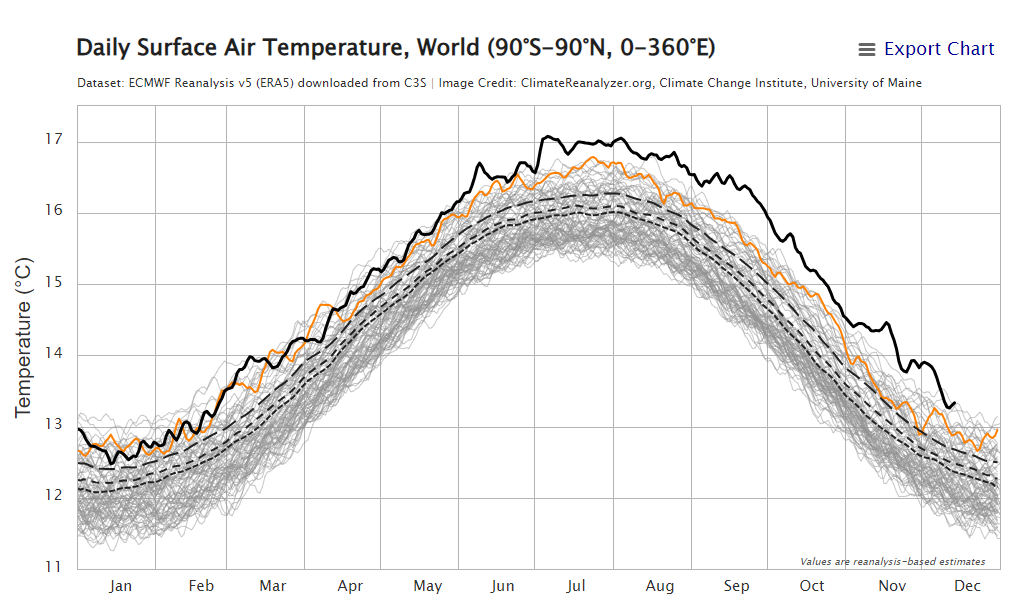
Bro is a comedy act. In commodities (where I work) we have people taking positions on buying/selling nat gas on the basis of the weather forecast, production and implied demand. Those people who sold this market with the view of the weather being bearish this month are pretty happy. Those who bought it are pretty unhappy. Trading is capitalism. Weather trading is capitalism. The beautiful thing about these markets is they tell you who's right and who's wrong. And you, my friend, would be broke if you tried to trade off your politics. Weather knows no politics, it just is. And this year, it just is the warmest we've had in our climatic record on a global basis (aka 1850). And that includes cold China in case you're wondering. Anyway, back to dissecting late Dec forecast busts.
-
Believe it or not, I'm capable of being able to see the globe. Because I forecast for...the globe. I forecast for 4 continents. Germany is not in a monthlong cold spell shattering records. Berlin is +10 anomaly today lol. Did you know Brazil is locked in it's hottest and also many areas driest Novy-Dec on record? I can cherrypick data too. The good news is we have a tool to determine how EVERYTHING is performing at a given time. Joe's a book salesman now. All his energy clients left him because he kept forecasting too cold. He went from widely followed in 2010 to little more than noise.

-
Someone's been following Joe Bastardi on twitter. You gonna blame underwater volcanoes next?
-
Honest question...did you read what I wrote? I laid out a multifactor reason for why this is warm. I've repeated it about 5 times over the course of the month and never once mentioned 'oversimplified El Nino', so not sure why I'm being quoted with that lexicon. Yes, background warming plays an issue too, but how much of that +10 you want to ascribe to that is anyone's guess. +1F? +2.5F? I honestly don't know. What I have said, and will continue to say, is that the EC weeklies gave you a very, very warm signal for end Dec, have been consistent with it since the first week of the month, and a lot of folks dismissed it for reasons relating to 'well MJO 8 is a colder phase and that'll solve it'. The Hovvies show you that VP200 progression alone is not enough to solve a problem. Even if you believe that the weeklies were underdamped (welcome to ensemble forecasting), you still had a massive, massive warm signal staring you in the face with a high degree of conviction. So even if it really did miss on amplifying p7, it STILL verified very close to final outcome. What does that tell you? It tells you that there were a confluence of factors...about 5 of them...as I'm now saying the 4th time...that led you this way. Tldr; the data was there to go very warm. People thought they could outperform the model at T2m and got smoked on it. We can call it what it is.
-
For the record, these were the temp anomalies shown for this Christmas week during the first week of December: and current (yes, I know shorter time horizon): If you had copy/pasted EC Weeklies as a forecaster, you feel pretty damn good about how this turned out. Rare that you get modeling in that strong of a conviction aligned with the seasonal work.
-
This is why these tools aren't meant to be viewed in isolation, there are more tools at your disposal than that. I did use a stratospheric signal, however, in conjunction with a view that PV displacement into Siberia would cause a significant source region issue for the month across the continent. When you overlaid that with December Nino analogs and an ongoing tropical forcing signal which argued dominant forcing in a bad place you had about 5 different factors pointing very warm into the continental US. I see what's put out on weather twitter, I see what gets put out by vendors...I see a lot of folks blaming the MJO and I don't think that's right in this case. I think it was forecasters underweighting other signals in lieu of overweighting MJO phase progression. For the life of me I don't understand sometimes the obsession with the tropical space as the answer to all. In this case, it wasn't. You had VP progression, you had some h5 response and....you still didn't have a source region. The reason you didn't have a source region is a combination of about 3 or 4 different things happening at the same time.
-
I boil the late Dec cold misses from a lot of folks down to an error in analyzing source region, not an error in model diagnosis of MJO. Yes the MJO 'signal' as it were lost some steam as it rolled forward, which may have tripped people up. But those weeklies, even with that h5 look were still very warm and will verify pretty well considering lead time.
-
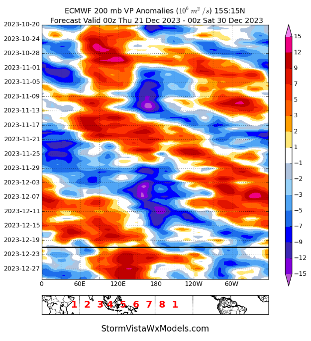
I'm very aware of how amplified the signal was...which is why I don't use the RMM's operationally. I think they're perhaps the worst way to illustrate tropical forcing to a forecaster. The reason VP was amplified is due to the strongly anomlous ENSO 4' SSTs yes, but there was also a traversing Kelvin Wave in the region which is and was clearly identifiable. Also had a couple of SHEM cyclones spawn out of that pattern. My point is that during the month forcing did shift east, h5 pattern had the appearance of more favorable for cold, but source region was still not conducive for colder conditions. I understand a lot of folks want to boil weather down to one single element causing a forecast miss. The MJO component wasn't as badly forecasted as you think. And the PV displacement had an absolutely crucial role to play in this moment, particularly as VP200 signature improved.
-
I don't think the MJO 'slowed' at all. I think you had a Kelvin wave continue to traverse as expected, but the signal was overamplified by modeling. It was less coherent as you rolled forward. I also think the biggest issue was PV displacement on the other side of the pole. Can't blame that entirely on tropical forcing. It was a source region issue. I asked this same question when the weeklies were showing this +PNA for the last week of Dec...what air are you advecting?
-
Ongoing source region issue, and will continue to be an issue in early Jan.
-
I think the best way for this to change that is PV consolidation and then some sort of Aleutian ridge to displace it towards NA. Need to have the cold air shunted towards NA after this coming PNA spike to fix the snowcover issue.
-
The Indian Ocean Dipole. Coupled atmospheric/ocean temperature pattern, measured by the difference between ocean temps off the coast of NE Africa and Sumatra. Indian Ocean climate influences (bom.gov.au)
-
He's making a fair point about the seasonal IOD collapse and subsequent weakening of the standing wave signal in the IO. Not sure that's necessarily the way out on it's own like he's indicating here, but the path analysis to source region shift makes sense conceptually.
-
Sure, in certain instances it doesn't work out with a colder Canadian airmass nearby to tap into for a plethora of reasons. We have certainly seen cases where promising Canadian airmasses and cold air supply are accompanied by jet suppression. However, historically, patterns with a normal to cooler than normal Canadian airmass providing available air to tap into are significantly better performing for the local area than alternative when it comes to snowfall. At least I've certainly found that to be the case in my career. You're talking about statistical odds. As I discussed yesterday, no one is saying it cannot snow ever in this pattern, I'm certainly not and I do like the 500mb pattern from a 1000 foot view. But it's not unreasonable to say it is statistically less likely than the alternative.
-
Missing Canadian HP from your equation.
-
Persistence forecasting for persistence sake is normally not a smart way to go about things. However, in certain patterns in certain years you can meteorologically have a good reason for going with it. That said, it depends on the meteorological variables on the board at a given time. I think there's been several years where if you took the persistence view on an extended/monthly basis it worked significantly better than trying to force a pattern change for X reason. I personally need strong evidence to copy in a persistence view, but I've certainly had bimonthly periods where I felt the pattern was just stuck, I had no real reason to believe it would change in any meaningful way for any appreciable length of time and went with it on a longer range basis. Yeah, there's some inherent variability in there for small windows but the big picture monthly degree day view made it somewhat negligible. For the record, I'm not taking the persistence view today.
-
I also agree.
-
I don't disagree here, but persistence is a view and sometimes it rewards a forecaster who has a healthy dose of skepticism. It works until it doesnt.