

NittanyWx
-
Posts
758 -
Joined
-
Last visited
Content Type
Profiles
Blogs
Forums
American Weather
Media Demo
Store
Gallery
Everything posted by NittanyWx
-
This is fairly similar to the 02 Nino forcing. 02 definitely didn't have the W Pac warm pool assist to the level of this year, and wasn't as warm in the east, but thought it's interesting.
-
Again, I'm not dismissing the science behind these ideas, my question is as an operational forecaster, is it actually helping you if you're wrong on key synoptic features and timing and using that as the primary basis for your forecast. How you decide to forecast is your own decision and I'm up to the individual forecaster. What I'm seeing myself is throwing into question the efficacy of it's usage for operational purposes when benchmarked as THE primary forecasting basis.
-
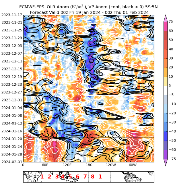
Not sure I'm really seeing that signature here for Dec, do see a Nino standing wave though and some hints of 30 day MJO cycle...
-
This is not a shot at Paul because I understand what he's trying to do, but according to this methodology, I should've expected a ton of ridging in Alaska and Greenland next week, a big trough Aleutians into Japan and the models today have the exact opposite sign in these very important polar areas, which are of key use for how we forecast the synoptic pattern
-
OK, so how many days is the lag? It's totally dependent on the pattern, speed of forcing, amplitude and interference/noise from ERW/KW right? This is the issue I have with some of this stuff because when we look at phase diagrams and h5 analogs we are often looking at 'same time' in the analog cases. Yet, when the analog fails, there's a lag, how much is in the eye of the beholder. For operational forecasting purposes, how are you supposed to beat the model with this form of forecasting? Like I think we are very kind at explaining away failures with this methodology and there's no real hard and fast rule, and that's how you get into timing is wrong, which means a forecast bust. Like this ventures into the 'oh I'm right, but wrong on timing'. 'Cold is coming eventually' and being off by 6 days isnt a good forecast... How many times this winter have folks used the MJO and just flat out whiffed on the temperatures associated with the given pattern? I think in terms of operational mid to longer range forecasting and I'm not convinced the methodology leads to more accurate results. I've been doing this for a long time too so I have a pretty big sample size.
-
There's also the ever sneaky bg global warming which is occurring too. Even the guys who don't believe in it are using trendline forecasts when making seasonal HDD forecasts which is their tacit acknowledgement that they can't ignore that contribution anymore...
-
Without giving too much away, there's actually quite a strong correlation to USA temperatures/degree days and stratospheric temps in the preceding month(s) for December, and that correlation strengthened significantly this year. When I bang on about source region and questioning cold displacement this is certainly something I look at closely. This is one example of about 3-4 others that I think have a physical role to play in development of the PV and displacement/location thereof. There does seem to be a tropo connection to it (wave breaking another crucial one). Indian Ocean Dipole/ENSO modulation of tropical forcing has a role to play in contributing to those warm winters too. What I look for are multiple signals pointing in the same direction for higher conviction forecasting. What I'm saying is GSDM/RMM based forecasting as the sole basis for a view has, historically, had a high bust rate...particularly in regards to timing which is often smoothed over as 'was right, just wrong on timing'. Not to burst anyone's bubble, but if you're wrong on timing, you're wrong... There are sub-seasonal influences all over the place. But generally speaking strong ENSO winters tend to be higher conviction forecasting because of the known correlations globally as well. There's always sub seasonal variables that modulate it though, and the key is to pick out what's a legitimate signal vs noise that can fuck up a forecast.
-
Yeah we can test that via historical ERA5 data, would be interesting to see the difference in h5 response with 30-40 day cycles vs slightly longer.
-
I don't want to sound dismissive of tropical forcing, it's got a role to play and a crucial piece of forecasting in the extended range. But the correlations are often overvalued by forecasts at the mid and high lats, especially in recent times. In my opinion the guys who use it as the foundational/principal basis for the majority of their forecasts tend to overvalue it's usefulness. More pieces to the puzzle. It's not the answer to all weather and it gets that reputation sometimes.
-
We're sitting here at MB's in a p4/p5 right now too...
-
Our coldest week of the year has come in P3/P4. Other atmospheric drivers will have something to say here...
-
Worth noting the amount of low level cold in this synoptic setup and the storm track H5 creates during the 'relax' period at 500. Could lead to an icy situation. Lotta HP in eastern Canada. Periodic reminder we don't live at 500mb
-
 Looks in line with expectations honestly. HRRR has a good handle on mixing
 -
This particular issue was a function of underdoing the upstream plains trough. Something it has done during nearly every significant arctic outbreak into Texas over the past few years. As the model recognizes the depth of HP/cold closer in, track gets closer to the coast as pattern becomes more amplified.
-
As we see often with these plains systems, sharper trof leads to more tucked in track. Expecting a lot of 2-4" with this one.
-
I suspect the Euro will end up getting sharper with the trough into Texas, which will likely amp any wave early next week in the East a bit more than it's doing currently. See this often in tail end plains events where the Euro suite underdoes everything until very late.
-
Not a classic setup by any means this weekend, but the pair of storms this week is actually helping to pull this storm north, but not too far for a decent portion of the coverage area. I'm optimistic with what we have on the table. Thinking a fairly classic late day/overnight quick hitter and outta here. Cold behind it, which aligns with the monthly view. The only pause I have at this stage is the amp risk. Less needs to 'go right' to produce snow with this one than the storm this past weekend however.
-
MLK week has my attention. It already had my attention, but now that modeling is aligning with longer range...got some pieces on the board
-
Two Mdt to high impact events NYC subforum; wknd Jan 6-7 Incl OBS, and mid week Jan 9-10 (incl OBS). Total water equiv by 00z/11 general 2", possibly 6" includes snow-ice mainly interior. RVR flood potential increases Jan 10 and beyond. Damaging wind.
NittanyWx replied to wdrag's topic in New York City Metro
i'm skeptical of that in CP given 850 low- 3,610 replies
-
- 1
-

-
- snow
- heavy rain
- (and 5 more)
-
Two Mdt to high impact events NYC subforum; wknd Jan 6-7 Incl OBS, and mid week Jan 9-10 (incl OBS). Total water equiv by 00z/11 general 2", possibly 6" includes snow-ice mainly interior. RVR flood potential increases Jan 10 and beyond. Damaging wind.
NittanyWx replied to wdrag's topic in New York City Metro
Again, the sfc low track isnt the primary issue for the dynamic forcing argument you're making. There was always going to be a clear period of SE fetch and marginal temps at the coast which were and have been highlighted as a hindrance. There was a thought for some here that 'dynamics' fixes that issue, as if the surface low is the primary focus of the storm on that front when the dynamic argument is mostly a function of secondary SW interaction and timing of that with the primary. Those two things aren't directly linked to each other. The issue with this marginal airmass and trying to thread the needle has been highlighted here by multiple folks for almost a week now.- 3,610 replies
-
- 1
-
-
- snow
- heavy rain
- (and 5 more)
-
Two Mdt to high impact events NYC subforum; wknd Jan 6-7 Incl OBS, and mid week Jan 9-10 (incl OBS). Total water equiv by 00z/11 general 2", possibly 6" includes snow-ice mainly interior. RVR flood potential increases Jan 10 and beyond. Damaging wind.
NittanyWx replied to wdrag's topic in New York City Metro
There was still going to be an 850 low issue and warm nose to contend with. The best dynamics for wraparound band have been clearly centered over New England. Track on the GFS is still DelMarVa to the benchmark or close to it. If the airmass weren't as poor it would help, but the 'best dynamics' are a function of vort/SW interaction which is primarily a timing issue/handling of that rather than surface low track.- 3,610 replies
-
- 3
-
-

-
- snow
- heavy rain
- (and 5 more)
-
Two Mdt to high impact events NYC subforum; wknd Jan 6-7 Incl OBS, and mid week Jan 9-10 (incl OBS). Total water equiv by 00z/11 general 2", possibly 6" includes snow-ice mainly interior. RVR flood potential increases Jan 10 and beyond. Damaging wind.
NittanyWx replied to wdrag's topic in New York City Metro
Trend to watch today is secondary vort interaction primarily regarding what happens on the back end for the interior. Comfortable with the idea of SE fetch being strong at 850 for a portion of overnight Sunday, to me coastal situation is pretty clear and has been for some time now.- 3,610 replies
-
- 3
-
-
- snow
- heavy rain
- (and 5 more)
-
Two Mdt to high impact events NYC subforum; wknd Jan 6-7 Incl OBS, and mid week Jan 9-10 (incl OBS). Total water equiv by 00z/11 general 2", possibly 6" includes snow-ice mainly interior. RVR flood potential increases Jan 10 and beyond. Damaging wind.
NittanyWx replied to wdrag's topic in New York City Metro
And will also say this for the 100th time, if the clown maps let you down that's mostly a 'you' problem if you don't look at the soundings and surface temps.- 3,610 replies
-
- 3
-
-
- snow
- heavy rain
- (and 5 more)
-
Two Mdt to high impact events NYC subforum; wknd Jan 6-7 Incl OBS, and mid week Jan 9-10 (incl OBS). Total water equiv by 00z/11 general 2", possibly 6" includes snow-ice mainly interior. RVR flood potential increases Jan 10 and beyond. Damaging wind.
NittanyWx replied to wdrag's topic in New York City Metro
Not much new on my side. Getting further confirmation marginal temp profile both at the surface and aloft made this a mixing ptype and accumulation issue for coastal plain (LI, City, S of 287/Merritt) and that the north of 287/merritt crowd was best positioned for significant accumulating snow and that has not changed.