

NittanyWx
-
Posts
758 -
Joined
-
Last visited
Content Type
Profiles
Blogs
Forums
American Weather
Media Demo
Store
Gallery
Everything posted by NittanyWx
-

2/13 Significant/Major Winter Storm Discussion & Observations
NittanyWx replied to Northof78's topic in New York City Metro
As far as the Euro/HRRR goes, this is one of the worst performances inside 36 hours I can remember. -
2/13 Significant/Major Winter Storm Discussion & Observations
NittanyWx replied to Northof78's topic in New York City Metro
Wilton, CT 8 AM Obs 31/30 3" even on the ground -
2/13 Significant/Major Winter Storm Discussion & Observations
NittanyWx replied to Northof78's topic in New York City Metro
It was mentioned several times that this would occur. The accumulations for this storm will likely double on non-paved surfaces. -
2/13 Significant/Major Winter Storm Discussion & Observations
NittanyWx replied to Northof78's topic in New York City Metro
Impressive stuff up in orange. This has been one of the weirder 24 hours leading into a storm in my career. Raising the totals for city and Island was right to do, but biting on the N/W sharp cutoff as a function of near term trends was not. -
2/13 Significant/Major Winter Storm Discussion & Observations
NittanyWx replied to Northof78's topic in New York City Metro
4-8" looks good for most (obviously less up by 84 and just north), again with the pavement caveat in urban areas and NYC. No need to fight the southerly trend this late. The returns in Tennessee weren't great this afternoon and think the trend south is a response to that. -
2/13 Significant/Major Winter Storm Discussion & Observations
NittanyWx replied to Northof78's topic in New York City Metro
Was on the phone with my old boss this morning, told him 6" in that north shore snow zone is probably reasonable top end. But it's a snow board 6", i think a lot of 2-4", 2-5" readings mostly on grass -
2/13 Significant/Major Winter Storm Discussion & Observations
NittanyWx replied to Northof78's topic in New York City Metro
Think you can go in the middle of the two ranges and be fine. This storm is very juicy, but very marginal too. Snow board will do better than 'on ground' It won't look or feel like 3-6" for a bunch of folks in the city (more than manhattan too, brooklyn et al). -
2/13 Significant/Major Winter Storm Discussion & Observations
NittanyWx replied to Northof78's topic in New York City Metro
Coastal marginal temps/mixing keep things at bay accumulation wise. it'll look nice for a period, you'll get some accumulation on grassy surfaces, but a lot of it will feel 'wasted'. It's still better than what it looked like a couple of days ago. This is game on north of the merritt/287. -
2/13 Significant/Major Winter Storm Discussion & Observations
NittanyWx replied to Northof78's topic in New York City Metro
Similar thinking, pending 12z adjustments in track. I like this a lot in the 287-84-merritt-91 box -
2/13 Significant/Major Winter Storm Discussion & Observations
NittanyWx replied to Northof78's topic in New York City Metro
taking under on that 12" by a significant margin -
2/13 Significant/Major Winter Storm Discussion & Observations
NittanyWx replied to Northof78's topic in New York City Metro
I like this a lot for north of 287/Merritt, though a large chunk of our area is gonna waste some of the overnight precipitation to sleet and mix at the onset with the warm nose above 850 and best diurnal timing. This is a frustrating one for the coast, especially the island, but that's often the issue in marginal storms like this one. -
There is also tangential/research being done on what impact any SSW event has on the actual PV and the spatial distribution of 2m temperature anomalies/h5 pattern. There are statistically higher odds of certain loading and post event patterns depending on whether a displacement or full split event occurs.
-
Tropics Check
-
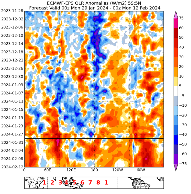
Once again, a clean eastward propagatation in subsidence...the models handled this well.
-
OLR/VPA tracking:
-
Background
-
We're talking about very different time horizons. I'm not using a Euro monthly inside d7, I'm not using a Euro weekly inside D7. I am seeing W Pac subsidence inside d7 on most dynamic models though, and I'm also seeing upper level pattern shifts in regions of the tropics I forecast for reflect those changes. I don't think persistence is going to outperform the models inside d7, personally. But we can verify on Feb 5-6 and see whether that's true or not. I suspect the model will win in this Jan 29-Feb 5 window.
-
Let's check back in a week and see whether the OLR/VP diagrams back up your claim. Because so far, this has 'rolled forward' as it were. Long term trends also are subject to sub-seasonal variability, so you're essentally boiling this down to a persistence forecast inside the d7 timeframe. I don't agree with that approach right now. Sub-seasonal variability still does occur even with bg warming and longer term signals you're describing persisting. If this was week 2 and this subsidence hadn't rolled forward, think it'd be fair to question whether this identified subsidence pattern ever emerges. But you're now arguing that a very strong +OLR anomaly west of the dateline is being misdiagnosed d 1-7 and therefore arguing more skill than the model inside the d7 window. I'm skeptical of that, but let's see.
-
Just talking about the weather, man!
-
Like there's a clear difference between saying 'the P8-1 response is not as clean as I'd hoped' in tropical forcing terms and arguing 'oh this is stuck in P7'. I have a hard time making the argument 'this is stuck in P7' when the eastward migration of VP200 anomalies has already occurred and there's a Subsidence/+ OLR signal just west of the dateline...and a pretty coherent one at that. That does NOT mean the MJO is 'not progressing'' What it does show, however, is the largely subjective nature of MJO usage...
-
Your OLR maps here also show an eastward progression and reduction in W Pac forcing for the 6-10 day window. So, as diagnosed, a reduction in W Pac forcing and shift eastward. Do you want to try again? Here's another way to look at it Now if you wanted to make the argument that E pac forcing is not responding as cleanly as you'd hoped to -VP anomalies in the region, I'd maybe think you'd have a point. But you didn't make that point, so...
-
Show your work.
-
I'm beginning to think you don't know what you're talking about. On the other hand @bluewave does know his methodology even though I disagree with it and his conclusions right now. I don't think the tropical forcing is as hostile as he's making it out to be.
-
I think your diagnosis of the forcing here is off. I see this as clear Nino forcing at the expense of the maritime continent, coinciding with +VP200 anomalies maritime continent. You've got about as clean of an eastward propagation in the VP signal as you'd like. If this doesn't work in traditional canonical fashion for more active (potentially snowier) purposes, it will likely be due to the erosion of source region combined with a poor placement/durability of high latitude blocking as a result of several factors discussed over the past few weeks in here. All valid, but not cleanly explained by tropical forcing alone. Right now and for the next week, however, you're getting the cleanest + 850 u-wind anomaly signal we've had so far this Nino with an eastward propagation of VP anomalies and a jet extension in the sub-tropics along with a fairly clean shut off of convection for about a week just west of the dateline (as shown in OLR anomalies too). Wheeler plots aside, those are the typical ingredients of a canonical back half Nino pattern from a tropical forcing/synoptics perspective. So if this doesn't work, I think you'll need to look at factors other than the tropics for why this split flow pattern did not deliver. I've got a few reasons ready and I'm not convinced this is going to offer much, but I don't agree with your assessment of tropical forcing right now.
-
It's a fairly coherent 1 week period of E Pac to Central Am forcing while coinciding with subsidence over maritime continent, Pretty clean Nino all things considered. If this doesn't work, it's likely for reasons unrelated to tropical forcing, which is the drawback to using this methodology. To me it looks like a split-flow NIno look for a bit though.


