

NittanyWx
-
Posts
793 -
Joined
-
Last visited
Content Type
Profiles
Blogs
Forums
American Weather
Media Demo
Store
Gallery
Everything posted by NittanyWx
-
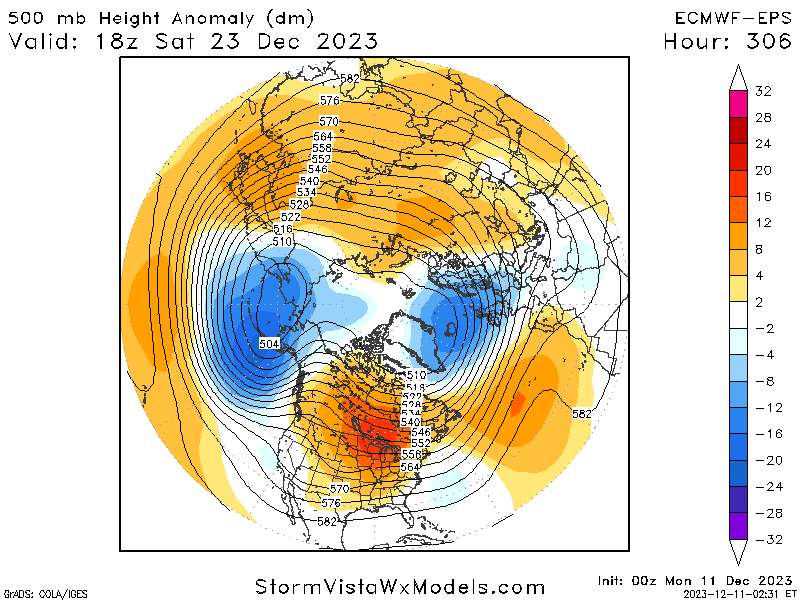
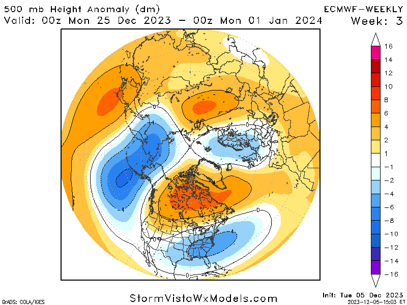
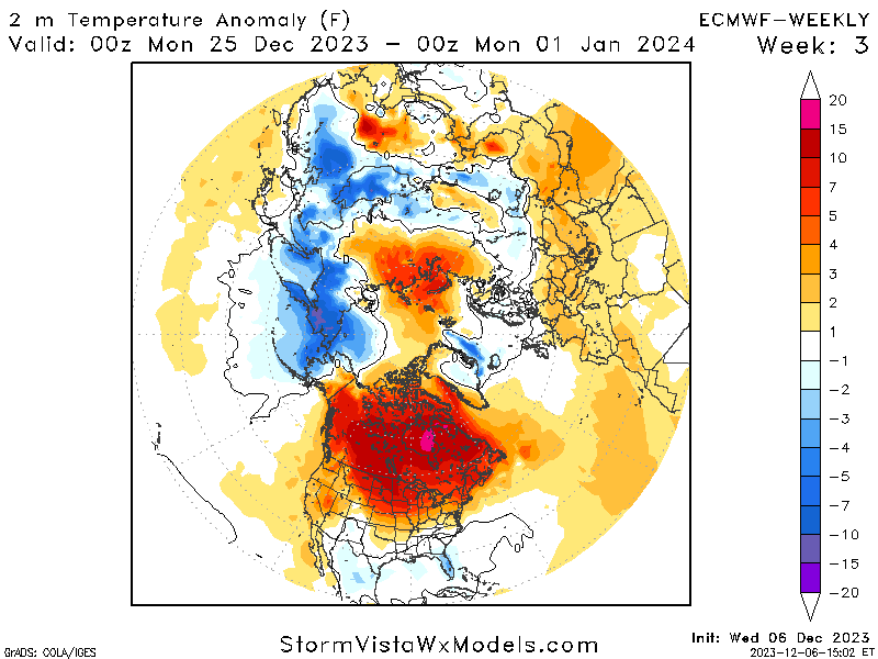
Just to circle back on the source region/weeklies discussion from last week: This look from the EC Ens mid 11-15 day now looks a lot like the weeklies from a couple weeks back at H5 Now at the time there was debate about MJO being the precursor to find cold in this pattern. However, as discussed then, the concern was that there wasn't cold in western Canada to be displaced and a lack of snowcover would modulate a very weak cP airmass in the event of a +PNA. The 2m temps from the EC Weekly for that period: So in my view, this strong + EPO forecast and roll forward was pretty well advertised. And shouldn't come as too much of a surprise given source airmass and seasonal factors tending to support that idea in December strong Nino's. The models are forecasting the MJO progression in both of these cases. So the use case of 'I can forecast the anomaly better than the model because I feel the model isn't seeing the true reflecfion of the MJO' actually led to negative forecast skill. Utilizing the weeklies in this case would've been prudent and understanding the source region wasn't sufficient are and were very important pieces of this puzzle.

-
He's lost the energy audience because they've been burned by him calling 55 of the past 2 cold shots.
-
The h5 charts at the end of the EC Ens don't look that much different from what the EC weeklies were showing in that post Christmas time period. Aleutian low, +EPO, +PNA but no source air. Flagged it at the time that this wasnt gonna be the cold look people thought it would be, but if that ends up rolling forward it's actually a pretty decent forecast from the weeklies.
-
It's not restricted to the warmer MJO phases. In general, our Oceans are very, very warm. We are increasingly breaking single day precipitation event records as a result of warmer temperatures as a consequence of, in part, higher oceanic heat content.
-
LFCLI30
-
This is very meta for me. I started as a teenager posting on Evans forum, went to Tristate and @jm1220 who I know personally and at Penn St, Adam and Tech and Mets and all those guys. Would have meteorologists chime in too...Rich Hoffman, Mike Ekster, Goodman, Craig Allen etc etc...those guys were invaluable to my understanding and building a foundation of knowledge. Big part of the reason I'm doing this professionally now is because of the online community then. Was constructive, learned a ton. I wish folks talked over each other less, it's much more combative now than it used to be. There would be arguments for sure, there would be weenies calling weenies a weenie. But the pros would kind of calm the masses and steer the discussion.
-
Long may this continue. This is an opportunity for market participants.
-
Intraseasonal variability in a year where we're a lot of extremes to the wet/dry side for several reasons isn't necessarily predictive in my mind. Patterns are quite amplified this year. I forecast globally and I'm seeing records fall way more often this year than I did in 2015. Which is a bit surprising to me.
-
AG2 has solid meteorologists working for them. They got too cute wirh their forecast, went pure academia focus instead of common sense 'high correlation, high probability' forecasting. It burned them. The other ones are mostly twitter noise for people who want to hype cold, but people do trade them and you see that creep into more reputable forecasters reports sometimes because people ask about it.
-
So I get exposed to a lot of different weather views in the space I work in and there were a lot of meteorologists and social mediarologists trying to downplay Nino influences this month. I was forwarded some stuff from: Direct Weather, Joe Bastardi, BAMWX, Mark Margavage, Atmospheric G2 and several other sources that were pumping up cold risk in the back half of December after a mild start. AG2 had some tweets comparing this to 09-10 because the October VP200 pattern wasn't canonical Nino and therefore December wouldn't be. It was out there. Maybe not here on this forum, but a surprising amount of folks tried to reinvent the wheel on their December US forecasts amid uncooperative signals left and right
-
When I'm talking about source region, I'm not talking about extreme arctic air. One of the challenges with airmasses from the north and west is that these airmasses can weaken over time when there isn't sufficient snow-cover. Looking at snow-cover anomalies and the Chinook showing up in the extended range...I'm struggling to find the snowpack build right now and a material change in that scenario. So that means any Continental polar airmass loses punch as it advects southeastward. A +PNA with no snowcover and cP airmass that doesn't have much of a cold punch to begin with weakens chances for snow. So what I'm looking for, and why I keep harping on the need for source, is to mitigate the risk of an empty trough and no real source for cold to accompany any coastal storm if and when El Nino forcing become a dominant driver again in the mid-lats and the seasonal +PNA trend re-establishes.
-
We're thinking alike
-
All about source region.
-
There's a source region problem. Perhaps that Kara-Siberia ridge starts dislodging some cooler air towards AK/NW Canada that can be tapped into at a later date when +PNA base state returns.
-
By the way, the VP200 Hovmollers are already in 'favorable' territory inside the 15 day. So the models are already 'seeing' the MJO
-
I will continue to harp on about the source region until it's resolved. It's the biggest inhibitor to anything other than a transient cool period right now. Kara Sea ridge developing 11-15 day should shunt some cooler air on this side of the pole, primarily focused over Alaska and hopefully some of NW Canada. For significant storm odds to increase along with a helpful airmass with it, this period would hopefully include some cold air draining into W Canada. At that point you'd look for a baseline Nino +PNA to re emerge which would, in theory, be the timing when things would line up for something more significant.
-
Thinking is for a transient few cooler days around mid month sandwiched around warmer ones. I still don't see permanent blowtorch, though I do think the post cool period could produce several much above normal days.
-
CPC did/does some work on ENSO and snowfall. The problem is the composites haven't updated since 2010, so it's a bit outdated.
-
Agree with this and was making a similar point yesterday. Lotta ways to skin a cat, tropical forcing being one of them, but would prefer it be some form of combination of influences to overcome background interference.
-
The model itself is forecasting the variables that are plotted into an MJO plot. Please explain how a model can catch up to its own forecast?
-
This is a good way to think about it. There's plenty of blocking right now over the pole and NAO regions, but the Pacific is very much non-cooperative. The net result is this pattern that isn't a prolonged torch, but any cold spell is pretty short lived and doesn't pack much of a punch here in early Dec. Week 2 trends look quite mild. Now if you have a cooperative Pac, you're aided by this blocking. So I'm not by any means throwing in the towel on winter. But 10 year normal temps in Dec aren't doing much snow wise right now. The playbook is Pac improvement, whether that be through the RWT, wave breaking, some strato influence, the MJO assisting with these things or some combo of all of them. Then the blocking can really help. And that's not to say Dec is a shutout, but I think the focus should be 90% Pacific right now
-
I'll go one further. Models have gotten a lot better at forecasting the MJO and subsequent RWT over the past 15 years. Part of the challenge is figuring out 'are you better than the model at forecasting the MJO?' And more importantly, are you better at diagnosing the downstream pattern than the model. I think a lot of folks treat the MJO like it's still 2009 and you had clear skill advantages and especially so in certain patterns. Not sure that's the case as much anymore given the improvements in the NWP space. It's a tricky game of when you're actually adding skill vs when you're actually taking decent modeling and making it worse with your own tinkering.
-
Well you were talking Holiday week in your post and my point is 'what air are you advecting'? If you're saying more towards January, I think you'd have a better case for it since there's potential for retrograde into EPO regions if you take that model verbatim. That Alaska look last week of December isn't what you want though.
-
If you're talking about the EC Weekly 500, it's missing any material source region and that trof is pretty empty. Essentially transporting mediocre Pacific air amid some storminess. Again, for the purposes of this winter you're looking for a source region build with Nino tendency to ridge out west. So in those breaks synoptically between ridges (you almost always get them), gonna really look to see if anything decent drains into W Canada. That's 90% of my focus right now. I liked the trends today a bit towards the end of the run today for that happening. But I need to see more synoptically for me to believe in a loading pattern that could deliver anything Christmas week. I don't have enough of a feel for what any +PNA or whatever would be transporting. Risk is a +PNA is just bringing in some modulated weak air and any potential system wouldn't have much to work with. My advice to this forum is focus on the source and less so the MJO. MJO 8 isn't the be all/end all for snow. Doesn't magically give you a source region.
-
I'd prefer Canadian prairies and upper Midwest, personally. Now thats not to say it CAN'T snow without those areas, but more often than not your source region is north and west and gets modulated and weakened without snowcover. More important to me is a loading pattern that at least brings in some cold into western Canada to tap into. We're lacking that currently. Models today towards the end are starting to show some signs of that, but that's really step 1 in the process.


