NittanyWx
-
Posts
758 -
Joined
-
Last visited
Content Type
Profiles
Blogs
Forums
American Weather
Media Demo
Store
Gallery
Everything posted by NittanyWx
-
The timing is literally half of the forecast verification, but to some it is a fungible concept
-
There's a large temperature spread between this December anomaly and the number's you're talking about. However, historically we do better when there's a source airmass in W Canada. I'm pretty clear in that I think the PNA is 'favorable' for a stormier solution, source is not favorable for a decent cold air supply and that leaves us with chances for snow, but less room for error.
-
I agree with this, but I also think people need to stop being so sensitive when it comes to pushback on that snow idea. If someone who's done this for a long time comes out and says 'I think that's wrong and a bad idea', it's not shutting down debate. It's literally the debate process. If you've got a view, take it. If someone pushes back on your view that's not shutting down debate. I'm sorry, but you're going to get challenged if you're going to make a forecast. Need to accept that. Especially if you continually have the same view and it blows up in your face. What I don't accept however, is selective verification. Far too many people try to convince people they were right after the fact or come with 'well I was wrong on timing and right on idea'...guys timing is as important to the forecast as the directional view.
-
2015 and 1982...wonder if those years have something in common with this one
-
I'd rather have a quote tweet reply from pretty much anyone else other than BAMWX
-
I think on the surface a reversion to +PNA with some sort of trof in the east is justified view for early Jan. There is a lack of significant source air to advect however which has been a common theme. Now if this PNA spike ends up being more GOA focused, perhaps there's an ability to dislodge some colder air. But in stormy situations with marginal airmasses, relying on a lot to go 'right' to thread the needle. That's where my head is at right now. I still see source region issues.
-
So just to update my thinking here from a few weeks back...we're in our much above normal temp phase post mid-month transient cool shot. Now we're left with the following: still no significant source region in Canada, dire snowpack in the mid-con and while we're seeing a PNA spike on most models...it doesn't have much of a source to tap into. I think we are likely going to see an erosion of the much aboves heading into early January, but I'd be lying if I didn't say I'm not loving what source air there is to work with at this stage and was a little more hopeful to see the EPO region shaken up instead of the bulk of this PV piece retro'ing back to Siberia. The EPS has been struggling, significantly at that, with 2mT cold bias so far this winter. I suspect it's doing so again late 11-15 day. That said, I am expecting to see the much aboves ease off a bit. H5 improvements are likely in early January. Tropical forcing should be more C Pac/E Pac based as well, but lacking available cold air to tap into I don't see much more than a marginally cooler period ushering in the first week of Jan.
-
There is an inherent disbelief in his post that a clear climatic trend is occurring because we somehow don't know what happened more than 150 years ago. It was a silly statement and wrong.
-
Lol what? I gotta ask, who told you we have 'no idea' of what happened more than 150 years ago?
-
It's not unique to NY either. Single day rainfall records are being broken and an increasing rate over the past 20 years. It's one of the cleaner climate change signals we have and passes the scientific sniff test.
-
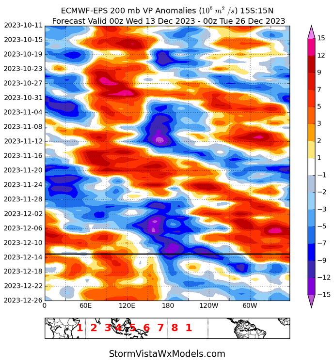
The more 'favorable' VP anoms did progress as expected. I do think the MJO signal was overamped and overhyped as a function of the pair of tropical cyclones and a Kelvin wave, but this was a pretty clean 200mb VP signal. I don't think this failed in that sense.
-
Yeah for Feb sure, was more talking Jan since that's where we kicked the can to at this point.
-
Just curious why you think it's the strato that's needed? We've had blocking over the pole and SSW's are mostly viewed as a way to weaken the PV to allow for more blocking. There's been the -AO, there's been a -NAO...to me this needs to be some sort of wave breaking signature to change things in the Pacific since default state in Nino years like this is +PNA. PV splits have a loose correlation to cold roughly 24 days after they occur, but that would then be kicking the can more to Feb, no? If you're looking for Jan help it's gonna need to be some combo of Pac changes in conjunction with dislodging some cooler air. I think you're on the right track with the idea of jet retraction, since in my mind the way for this to happen is retrograding +PNA which amps into AK and finally dislodges some cooler air and aims it towards NA.
-
Yes I agree its a better look synoptically in terms of shutting off the Pac flow and potentially dislodging something colder out of the artic and pushing it towards this side of the pole. Maybe not hammer cold, but an erosion of the much above. When we spoke 10 ish days ago, i felt the way to do this was with some sort of PNA retro, amp into AK after jet retraction and the Kara Sea piece allowing for some cold to be able to be tapped. This is in a way similar to that idea and an important step in this process. Split flow would increse the odds that pattern would deliver some sort of storm with as you head into that Jan 5-15 window. Let's see if it rolls forward. As I said before, I'm in the agnostic camp at that range.
-
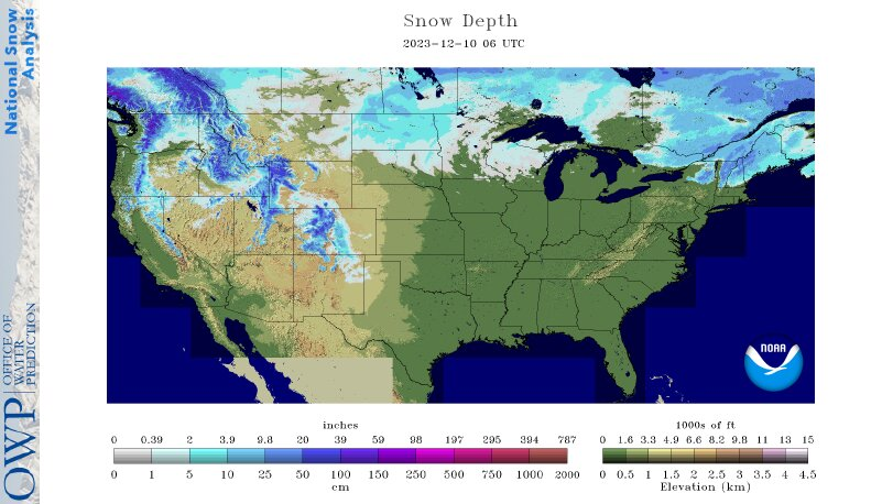
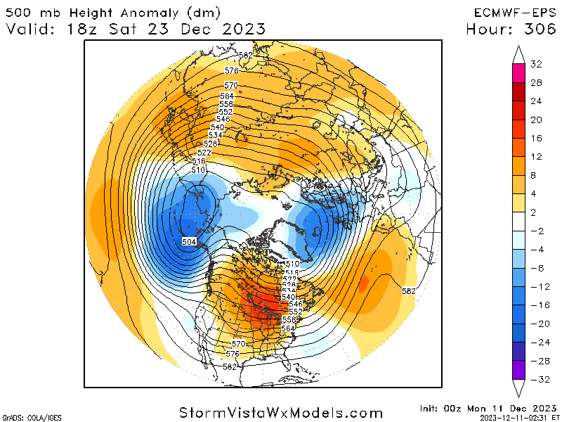
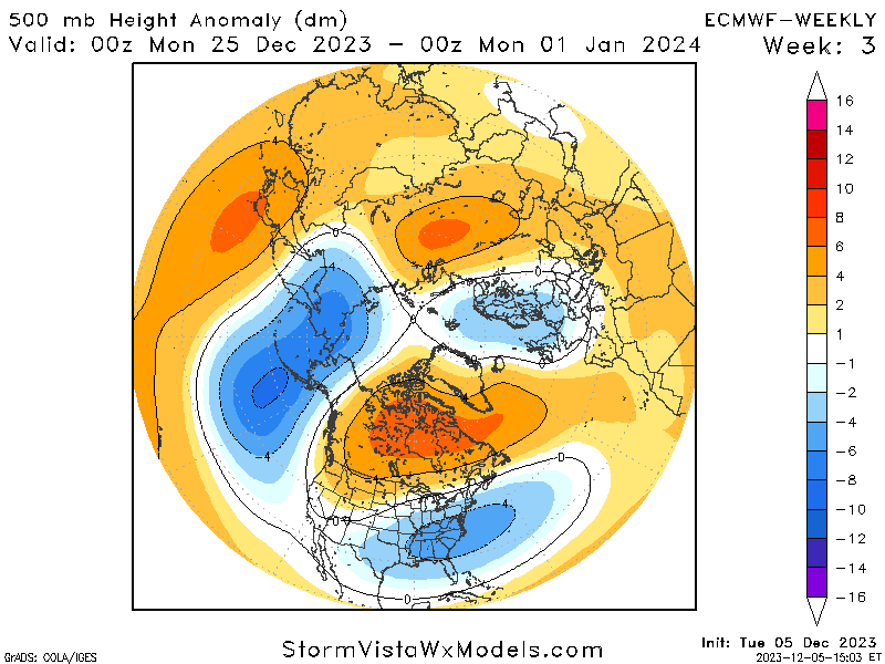
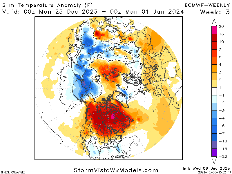
Couple things...first, you had a midcon snowpack then: Vs now: And really my point a couple weeks ago was 'what air are you advecting?' when you went back to a +PNA for that Christmas week. Not saying it can't snow from a one off, but I am saying this current setup that was shown for the last week of Dec wasn't a modeling error. It actually looks like a really good forecast. So now it's really to me about finding a way to dislodge that extremely +EPO and also weaken that Pac jet extension. Yeah i don't think climo supports the Pac jet staying extended for long, but I still am of the belief that some source region is needed after the Pac air floods most of NA. It's possible, but I really do believe if you want a prolonged snowier period in this type of climate you need some Canadian HP and it would help to have some form on a midcon snowpack that is usable in a baseline +PNA scenario. I'm agnostic at the moment. Think both things are possible, but I'm not at the probable stage until I see some changes in the AK region.
-
Just to circle back on the source region/weeklies discussion from last week: This look from the EC Ens mid 11-15 day now looks a lot like the weeklies from a couple weeks back at H5 Now at the time there was debate about MJO being the precursor to find cold in this pattern. However, as discussed then, the concern was that there wasn't cold in western Canada to be displaced and a lack of snowcover would modulate a very weak cP airmass in the event of a +PNA. The 2m temps from the EC Weekly for that period: So in my view, this strong + EPO forecast and roll forward was pretty well advertised. And shouldn't come as too much of a surprise given source airmass and seasonal factors tending to support that idea in December strong Nino's. The models are forecasting the MJO progression in both of these cases. So the use case of 'I can forecast the anomaly better than the model because I feel the model isn't seeing the true reflecfion of the MJO' actually led to negative forecast skill. Utilizing the weeklies in this case would've been prudent and understanding the source region wasn't sufficient are and were very important pieces of this puzzle.

-
He's lost the energy audience because they've been burned by him calling 55 of the past 2 cold shots.
-
The h5 charts at the end of the EC Ens don't look that much different from what the EC weeklies were showing in that post Christmas time period. Aleutian low, +EPO, +PNA but no source air. Flagged it at the time that this wasnt gonna be the cold look people thought it would be, but if that ends up rolling forward it's actually a pretty decent forecast from the weeklies.
-
It's not restricted to the warmer MJO phases. In general, our Oceans are very, very warm. We are increasingly breaking single day precipitation event records as a result of warmer temperatures as a consequence of, in part, higher oceanic heat content.
-
LFCLI30
-
This is very meta for me. I started as a teenager posting on Evans forum, went to Tristate and @jm1220 who I know personally and at Penn St, Adam and Tech and Mets and all those guys. Would have meteorologists chime in too...Rich Hoffman, Mike Ekster, Goodman, Craig Allen etc etc...those guys were invaluable to my understanding and building a foundation of knowledge. Big part of the reason I'm doing this professionally now is because of the online community then. Was constructive, learned a ton. I wish folks talked over each other less, it's much more combative now than it used to be. There would be arguments for sure, there would be weenies calling weenies a weenie. But the pros would kind of calm the masses and steer the discussion.
-
Long may this continue. This is an opportunity for market participants.
-
Intraseasonal variability in a year where we're a lot of extremes to the wet/dry side for several reasons isn't necessarily predictive in my mind. Patterns are quite amplified this year. I forecast globally and I'm seeing records fall way more often this year than I did in 2015. Which is a bit surprising to me.
-
AG2 has solid meteorologists working for them. They got too cute wirh their forecast, went pure academia focus instead of common sense 'high correlation, high probability' forecasting. It burned them. The other ones are mostly twitter noise for people who want to hype cold, but people do trade them and you see that creep into more reputable forecasters reports sometimes because people ask about it.
-
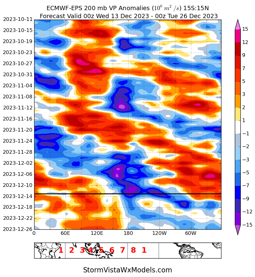
So I get exposed to a lot of different weather views in the space I work in and there were a lot of meteorologists and social mediarologists trying to downplay Nino influences this month. I was forwarded some stuff from: Direct Weather, Joe Bastardi, BAMWX, Mark Margavage, Atmospheric G2 and several other sources that were pumping up cold risk in the back half of December after a mild start. AG2 had some tweets comparing this to 09-10 because the October VP200 pattern wasn't canonical Nino and therefore December wouldn't be. It was out there. Maybe not here on this forum, but a surprising amount of folks tried to reinvent the wheel on their December US forecasts amid uncooperative signals left and right