IrishRob17
-
Posts
10,629 -
Joined
-
Last visited
Content Type
Profiles
Blogs
Forums
American Weather
Media Demo
Store
Gallery
Everything posted by IrishRob17
-
True but I'm a results guy, I don't care what the spread is.
-
I'm still in shock, not used to them performing so well in big games but this is the Freeman era and what a job he and staff did! That said, concerned about the mounting injuries but this is incredible. HERE COME THE IRISH!
-
I had a few periods of legit light snow between 9-11am but it lasted less than 10 minutes each time and melted on contact.
-
There’s some occasional flakes
-
Without question, THE Postage Stamp is a piece of this neck of the woods! And you know if you do t check in every once in a while I'll go looking for ya.
-
The .41", mostly before midnight, put me solidly above normal for precip for December. 43/41 at the moment.
-
I know it's been expressed in the past for us to have an annual thread to make looking old posts easier so here it is folks:
-
As is tradition here is our new annual thread, Happy New Year to all of us hinterland folks.
-
Even a lighting strike up here near the 'Canadian border'
-
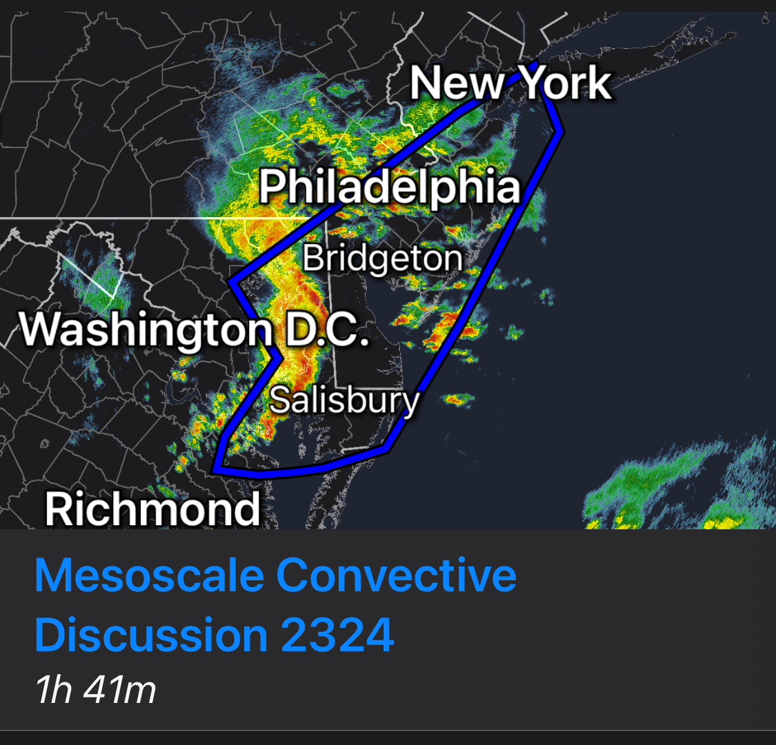
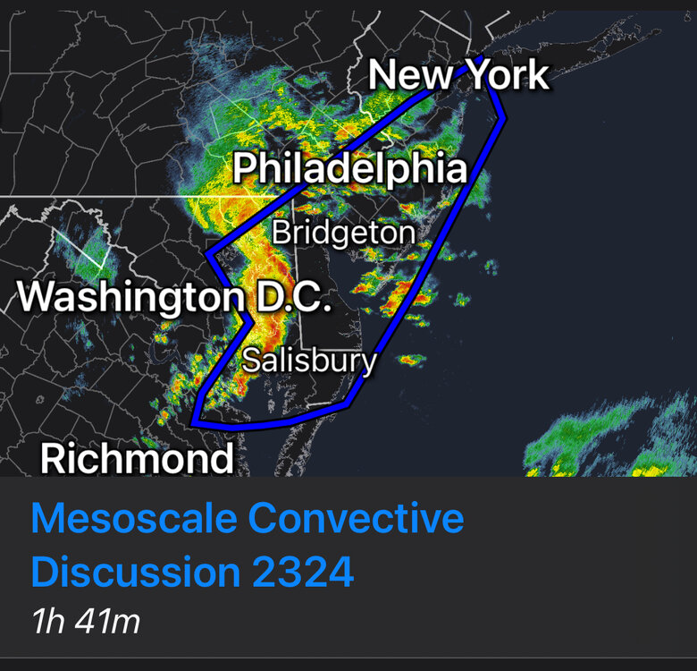
Mesoscale Discussion 2324 NWS Storm Prediction Center Norman OK 0556 PM CST Tue Dec 31 2024 Areas affected...Parts of the Mid Atlantic Concerning...Severe potential...Watch unlikely Valid 312356Z - 010200Z Probability of Watch Issuance...20 percent SUMMARY...Strong thunderstorms will spread northeastward through the evening. Small to marginally severe hail and locally gusty winds remain possible. A brief tornado also cannot be ruled out near the Delmarva region. DISCUSSION...A long-lived thunderstorm cluster is moving northeastward across parts of eastern MD/VA early this evening, in association with a strong midlevel shortwave trough and 1000 mb surface low moving across the Mid Atlantic region. The northern portion of this cluster appears to be outpacing the northward return of modest surface-based instability, but increasing elevated moisture and buoyancy will help to maintain the cluster as it approaches DE and southern NJ. MUCAPE increasing to near/above 500 J/kg and strong effective shear will continue to support organized convection. Small to marginally severe hail will continue to be possible with both the ongoing cluster and with elevated storms developing ahead of the cluster, due to cold temperatures aloft (below -20C at 500 mb) associated with the shortwave trough. Increasing low-level stability may tend to limit the severe-wind threat with northeastward extent, though locally strong/damaging gusts may accompany the more organized convective elements, especially from southern NJ into the Delmarva. A brief tornado also cannot be ruled out where convection remains near-surface-based, especially near the Delmarva where the southern portion of the ongoing cluster will intercept modestly increasing MLCAPE. ..Dean/Bunting.. 12/31/2024
-
It's going to be too cold to snow, just saw it on social media. It's ovah.
-
Yeah, there's a clear difference.
-
He’s keeping it real for what our modern climate is, clearly some here can’t handle the truth.
-
In addition people that know you follow the weather then ask "I see we're getting 3 feet of snow on Martin Luther King Day, what time do you think it will start?"
-
Perhaps such people get five posted?
-
Didn't see 40s up here yesterday, 37 now. Some serious fog eating snow though, so the pack is gone, as expected.
-
Negative Ghost Rider.
-
 My stone driveway is still a sheet of ice, it's become more evident as the air gets underneath it. The paved areas, decks, cars are free and clear of ice. Up to 36 with .27" thru the tipper.
 -
I had a trace here early this morning, up to 34 now, with 2.5" at the snow stake but my solid snow cover is starting to show some holes in it as it becomes slushy.
-
28/24 here near KMGJ
-
7 for the low here as well with a solid 3” snow cover still, for now. Up to 20 degrees now.
-
Maybe down there. I was above freezing for less than 6 hours, back below freezing here at 6:30pm Christmas Eve.
-
Definitely dropped lower than thought, I was surprised to see 6 degrees on the Davis.
-
Extended summer stormlover74 future snow hole banter thread 23
IrishRob17 replied to BxEngine's topic in New York City Metro
Festive Forky spreading cheer the whole year through. -
https://forecast.weather.gov/product.php?site=NWS&issuedby=OKX&product=PNS&format=CI&version=1&glossary=1&highlight=off