

IrishRob17
-
Posts
10,629 -
Joined
-
Last visited
Content Type
Profiles
Blogs
Forums
American Weather
Media Demo
Store
Gallery
Everything posted by IrishRob17
-

Extended summer stormlover74 future snow hole banter thread 23
IrishRob17 replied to BxEngine's topic in New York City Metro
Ah, I recall that now, no fun. I suspect you'll be fine up here tomorrow, safe travels. -
Extended summer stormlover74 future snow hole banter thread 23
IrishRob17 replied to BxEngine's topic in New York City Metro
Too bad your flight isnt today -
It’s been gusty here since last night
-
Flurries here again this morning along with the gusty winds.
-
1.68"
-
Feb was 2.34"
-
Well over 57" since last June.
-
Sure, with one caveat, the Feb total is just what the tipper registered which is likely off due to the snows. I'll have to check my records at home later if you want an accurate total for Feb: Oct: 3.69 Nov: 2.13 Dec: 8.07 Jan: 3.51 Feb*: 1.78 Mar: 2.11
-
I was looking around yesterday at all the puddles in the fields, the water table is certainly up there these days.
-
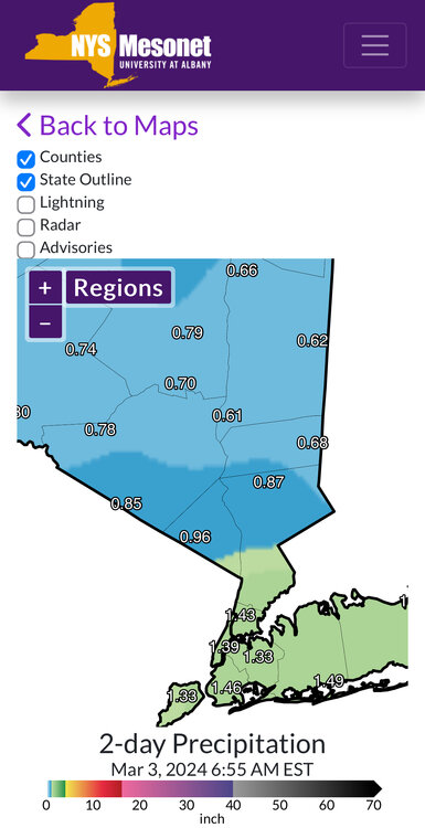
*All rainfall reports that Upton included. Less than an inch up here on the northern frontier, .61" IMBY
-
After a low of 28, high of 61, first 60s since 11/17/23
-
Minor details
-
As you know, when they say impressive for out there...it's the real deal
-
Doing some virtual snow chasing later this week, the forecast discussions coming from out west are entertaining, heres NWS Reno this morning: Thursday-Sunday | Major Winter Storm, Blizzard Conditions Possible: * The message remains consistent--a storm that`s impressive even by Sierra standards will arrive Thursday morning, with strong and potentially damaging winds along with increasing intensity of mountain snow during the day. For lower elevations, valley rain and a rain/snow mix for foothill locations is projected to begin Thursday night and continue through Friday. By late Friday night, a blast of cold air will lower snow levels to all valley floors, with periods of snow Saturday through Saturday night. Some of the guidance even holds on to snow continuing through Sunday night, which would lead to even greater snow amounts than indicated in our current Winter Storm Watch statement. * We`re getting to the point where snowfall amount probabilities in the Sierra/northeast CA won`t even matter--being replaced by certainties. Snow amounts will be so much and difficult to accurately measure due to strong winds producing prolonged periods of near zero visibility, and blowing/drifting snow capable of burying vehicles and making it difficult to locate roads. Even walking outside would not be advised during this storm as a person could quickly become lost or disoriented. * Lower elevations and foothills will likely experience strong and potentially damaging winds for the Thursday-Friday time frame, with high chances (70+%) for peak gusts 55+ mph. Wind prone areas including US-395/I-580 from eastern Lassen County southward across far western NV and into Mono County, and US-95 around Walker Lake have about a 50/50 chance of seeing peak gusts 70+ mph. Blowing dust could produce areas of poor visibility downwind of deserts and sinks in northwest/west central NV. * Western Nevada foothills (5000-6500 ft) will have the most challenging projections for snowfall amounts, as snow levels fluctuate around 5000-5500 feet for much of Thursday night- Friday. Depending on how much moisture spreads over and if snow intensities are sufficient to support daytime accumulations, the amounts could vary from less than 1 foot to as much as 3 feet. The higher end totals would occur in areas that remain all snow starting Thursday night, and also if snow continues to pile up through Sunday. Valley floors across the main urban areas (Reno- Carson-Minden) and the Surprise Valley still have about 60-70% chance of receiving 6+" and 15-30% chance of 12+" (except probabilities are a bit lower for Reno`s lowest valleys), while farther east across west central NV (Lovelock, Fernley, Fallon, Yerington, Hawthorne), amounts still look to be notably lighter, with less than 15% chance of exceeding 4".
-
Just enough freezing rain earlier this morning to make the commute interesting, car crashes along with folks falling on untreated pavement. Blue skies now and up to 34-35.
-
Daffodils. Daffodils sprouting everywhere!
-
https://www.mynbc5.com/article/saranac-lake-ice-place-closed/46708289
-
Agreed on the sample size. Four or so years ago my measured average was around 5" higher than what the NWS had for KMGJ but the last few years have changed that, now it's down to about an inch difference between the NWS and my records.
-
The January 2015 blizzard was also a fail IMBY but I did manage 2.7" out of that one but managed a decent winter overall.
-
Yeah, that year blew chunks. I measured .4 for the big blizzard... Another reason it sucked, I figured lets go big and have a season snowfall in the single digits but I measured 2.3" in early April which got me into double digits.
-
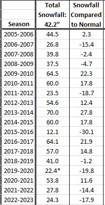
I have the opposite, the back yard has bare spots, front yard still covered, as of this morning anyway. Here's a snapshot of my stats, you can see what I meant by three out of the last four seasons
-
Good morning Rich, I hope all is well my friend. Not much to report here, down to 4" at the snow stake but plenty of bare spots now. Low was only 23 this morning, up to 40 now. The previous two mornings lows were 13 and 12 with highs in the upper 30s. As for seasonal snowfall I'm at exactly 29.5", which is just slightly below normal now. When compared to the NWS seasonal average I am only .5" below normal as of today, when compared to my running totals, which go back to 2005, I am now 2.5" below normal. Three of the last four years have really done a number on my seasonal snowfall average, and it doesn't look like this year is going to help it any unless we get something big in mid-March. Not holding my breath though.
-
Refresher snow & obs between ~midnight and Noon Sat Feb 17 2024
IrishRob17 replied to wdrag's topic in New York City Metro
2.3" here with 15:1 ratios -
I don’t believe there are any but @BxEngine would know for sure. Even if there is one who knows how it compares to where you are. KMGJ is two or so miles away as the crow flies and the differences between there and here are interesting, no snow measurements there though, just looking at temps and rainfall. Legoland is seven miles away and the differences can be eye opening.
-
Melted down to nice 15:1 ratio.


