stormy
-
Posts
1,500 -
Joined
-
Last visited
Content Type
Profiles
Blogs
Forums
American Weather
Media Demo
Store
Gallery
Everything posted by stormy
-
The source region is excellent!!! This could work if cold air to the northwest is progressive and the Atlantic ridge co-operates.
-
11.6 this morning.
-
JB was talking about La Nina coming to life and screwing up the MJO last week.
-
PSU is a special character that we tolerate. I gain special insight from his posts occasionally but sometimes go to bed after tuning out. I'm sure he does the same with my posts...............
-
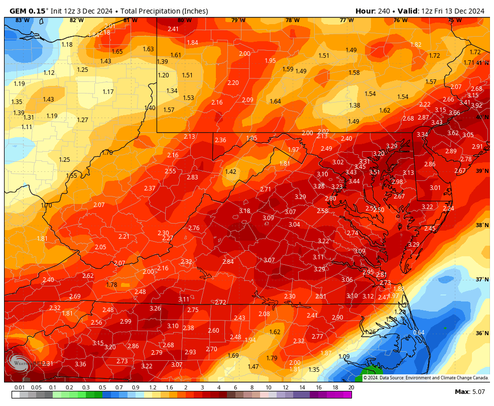
The latest GEM could put a dent in our moderate to severe drought IF it verifies

-
I tied a record low for this morning going back to 1893!!! The record was 10 set in 1976. This morning I recorded 9.7 rounded up to 10.
-
I will give everyone a blast at yesteryear snowstorms in December very soon. White Christmas???? Would you believe 3 big-time in 7 years??????
-
20.6 this morning
-
I hope you're right! Droughts always break eventually. What better way than with 6 - 12 inches of snow. D.C. can have the 12 inches. I'll take 6.
-
As long as we stay in moderate to severe drought, these types of dropouts will not be unusual. Here's the deal:
-
This cold pattern likely to last thru mid month then warm up thru Christmas IMO. No reload evident after mid month on EPS or GEFS at this time.
-
make that -0.4 for both winters.
-
2013 - 14 was -.04 , 2012-13 was - .04. I received 29" in 13 and 41" in 14. That is close to what the coming winter will be................. Thoughts
-
I NEVER care to nitpick. I only pray that the models evolve to a December 1962 or 2009 pattern. I highly doubt this but a La Nada pattern gives me 20 inches compared to 10 inches...............
-
I understand that the chart is only a snapshot in time, but folks new to this hobby need to understand that we usually do better with a trough axis to our west (Ohio Valley). Case in point, the 18z GFS drops a 2 - 5 inch swath of snow across Virginia on Dec. 9 with a weak trough axis back over the western Ohio Valley. Thanks Cape
-
I'd rather see that trough axis over Louisville instead of Philadelphia.
-
Yeah, the 06z A1 does look interesting! I hadn't looked at it today. A little beef up in stead of back down. Surface is marginal in mid 30's but 850's look good at minus 4! When will the 12z be available?
-
It was interesting until I looked. 12z even slashes the western mountains...................
-
The GFS and GEM are both backing off. Euro will be interesting.
-
Happy Snowfall to all the DC Snowgeese!!!. I had 1/4 inch in a squall yesterday evening. Today is very unusual for 11/22 and is a perfect illustration that under the right atmospherics in 1965, 1985, 2005 or 2025............................. It is going to snow on the D.C. region on Nov . 22. This is not supposed to be possible on Nov. 22! ............................ Keep hoping for the right atmospherics which will always deliver for you............................
-
That digging bundle of energy over Indiana/Illinois will enhance snowfall for upslope regions on Friday.
-
You will generally witness a 4 degree drop per 1000 ft. elevation. My snowfall observation through the past 40 years says 3 inches per 1000 ft.. I have a lot of experience comparing 1800 ft. to 2800 ft .
-
According to the GFS/ECMWF, your backyard at 2500 ft. will probably get a foot. At Snowshoe, the elevation will likely create whiteout conditions with wind, fog and blinding snow.
-
My heart goes out to you!! We had serious drought in Augusta earlier but recent rains have helped.
-
26 this 7 am. GFS , 11.3 inches of snow in Staunton on 12/3....... Really??