stormy
-
Posts
2,116 -
Joined
-
Last visited
Content Type
Profiles
Blogs
Forums
American Weather
Media Demo
Store
Gallery
Everything posted by stormy
-
The pattern in late week would not benefit us whether it was Jan. or April. Up-slope snow does not affect areas east of the mts.. We are in a down-slope region.
-
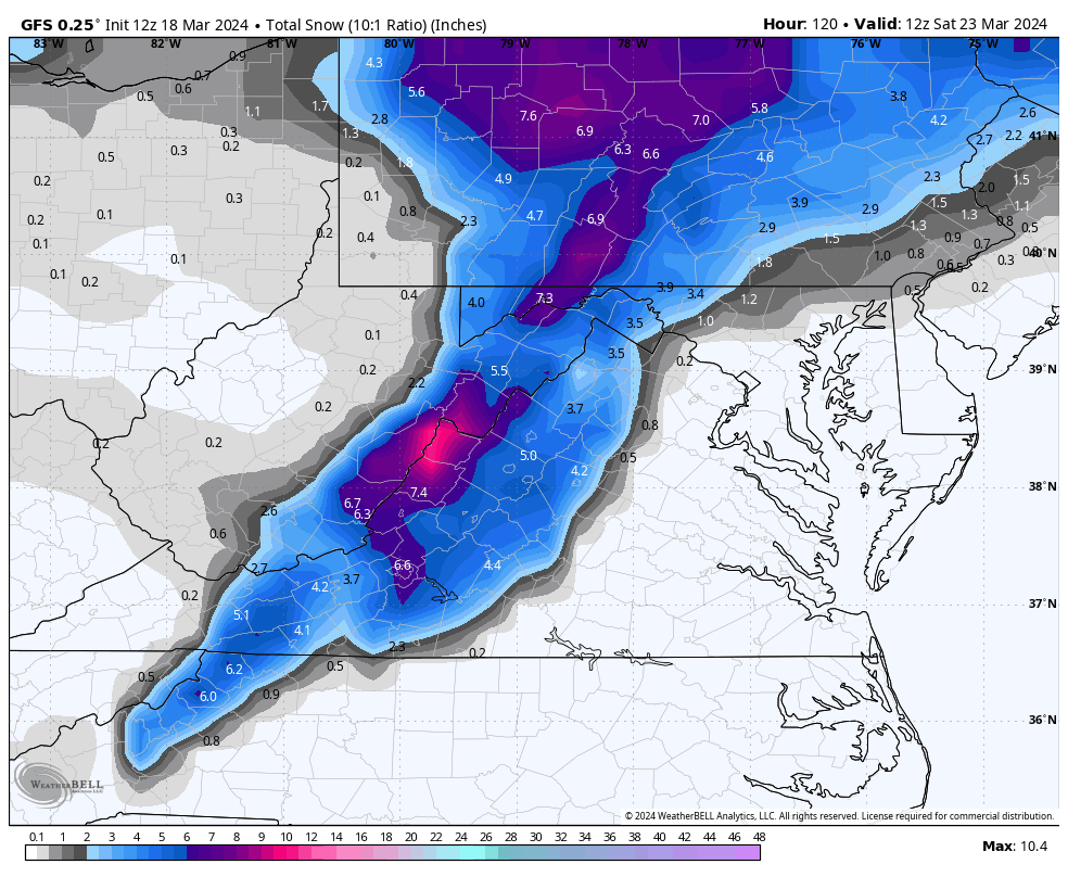
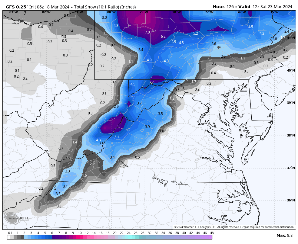
.17" rain on Wednesday. 2.38" so far in March vs a normal of 3.51". I will plan to post tomorrow or Monday about dry Marches in my region related to previous winter snowfall. A 3 model blend gives the higher elevations of W.Va. between Elkins and Snowshoe 9. 7 inches of snow between Wednesday and late Friday.
-
22 early this morning. 11 years ago this morning was a winter wonderland at my place! 6.5 inches of snow and 28 degrees. 3.5 inches fell on Palm Sunday afternoon and 3 more inches Sunday night. Mar. 25, 2013.
-
The squirrels are shivering this morning at 22 degrees!
-
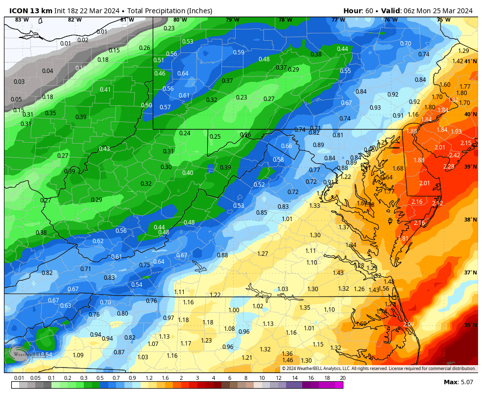
.83" total. As I suspected yesterday afternoon the Icon was out to lunch with only .53". The GFS nailed it at .82" I have discovered an astonishing relationship between March rainfall and previous winter snowfall during the past 8 years. More on this when March welcomes April.
-
I must believe the 18z ICON is out to lunch because I see greater lift potential to the west of 95.
-
The 18z ICON pushes the heavy swath of rain to coastal areas.........................................................

-
Unfortunately, I must agree! The heaviest swath is shifting east. We will know by 00z Sunday.
-
According to the 18z NAM 3 and 12, the heaviest swath of rain will run up east of the Blue Ridge toward 95.
-
March has been very dry across the Central Valley. I have received a total of 1.38" compared to a normal on March 21 of 2.31". This is only 60% of normal rainfall. This reality has resulted in a rash of wildfires aggravated by high winds.
-
22 at 7 am. A soaking rain will really help with the very dry conditions, smoke and wildfires. A 5 model blend gives D.C. 1.65" and Augusta 1.02". All important Luray receives 1.23".
-
Your intelligence is bold face. The other Clowns are to be discounted.
-
Oh well, I'm more interested in a soaking rain. Waynesboro has declared an outside burning ban because of how dry we're getting. My latest 4 model blend gives Waynesboro .89" Friday night/Saturday. Nice!
-
28 early this morning is a lot better than 12F at the summit of Spruce Knob. Rt. 250 is covered with snow at the Va./W.Va. state line at 4332 ft.. Looks like maybe an inch.
-
Elliot Knob 20 miles west of Staunton is 4463 ft. and expecting 4.4 inches of snow Friday night. Hike to the summit. Reddish Knob about 20 miles north on the Augusta/Pendleton county line at 4398 ft., has a narrow paved road to the summit with large potholes.
-
On Sat. morning I can drive to 4400 ft. withing 20 miles of my place. A lot better than 95 miles to Cannan for 3400 ft.. , 1000 ft. lower. Of course that would be 70 miles n.w..
-
Thanks Cape. We both know this is not likely to happen. The 18z GFS has dropped from 5.0 to 2.9" for Augusta. But, during a slow week, it gives us something to chat about. Wow! the GFS increased from 1.38" to 2.04" qp for Augusta!!!
-
The 12z GFS and GEM runs are becoming a little more bullish on the WOTBR snow threat for Friday night, both op and ens. GFS op - 3- 5" both 10:1 and Kuchera qp 1.38" previous .65"......... GEFS 1 - 2 " previous .3" ......qp .55" previous .30" GEM op - 0 ................ CMC ens .8" previous .4", qp 1.05" previous .60" ECM 0 ECM ens 0 A long shot but the trend is my friend.
-
12z GFS still likes accumulating snow for the Valley Friday night. Quebec high, ENC low, timing could work.

-
This looks fine for Friday night in Augusta County. Track of lp is encouraging.

-
A high of 70 on Friday felt wonderful. Of course, that was cool compared to 1944 when it was 86 in Staunton! And warm compared to 1993 when it was minus 3. My peach tree will be in bloom in another week or 10 days. Apples and plums later. Most fruit will freeze this year.
-
You are wise to question theory through observation. 50 years ago the accepted last frost date for my region west of the BR was May 10... Today, horticultural experts have moved the last frost date to May 15. In the fall the first frost date usually comes 10 days later than 50 years ago.
-
What Went Wrong in Winter 23-24/Base State/Will It Ever Snow Again??
stormy replied to WxUSAF's topic in Mid Atlantic
Thanks for this wealth of information! The 50's and 60's gave me a cautious attitude about PDO influence because most of the 50's averaged -1 to -3 (snow drought) then + 1 to +1.7 from late 57 - 62 snowy , then negative again -1 to -2 for the rest of the 60's which also produced some cold snowy winters. I am beginning a study of AO/NAO influence on MA winters and will have more comments as my study bears fruit over time. An early on empirical snapshot tells me that the AO is usually a more reliable factor than the NAO. -
What Went Wrong in Winter 23-24/Base State/Will It Ever Snow Again??
stormy replied to WxUSAF's topic in Mid Atlantic
The current "deeply negative" PDO began in 2020. That is only 4 years ago. Prior to that it was moderate/strongly positive. During nearly all of this time we have been well below normal snowfall whether or not it was cold enough to snow. A lot of this has been dependent on timing and track of precipitation bearing systems. -
What Went Wrong in Winter 23-24/Base State/Will It Ever Snow Again??
stormy replied to WxUSAF's topic in Mid Atlantic
Regardless of your theory, I'm not convinced a positive PDO will be the magical elixir for snowfall because the 50's and 60's both witnessed a mostly negative PDO with a brief positive from about 1958 - 1962. Under mostly negative conditions as we have witnessed since 2020, the 50's witnessed below normal snowfall and the 60's witnessed above normal snowfall. I don't find any significant impact because of the PDO phase.