stormy
-
Posts
1,500 -
Joined
-
Last visited
Content Type
Profiles
Blogs
Forums
American Weather
Media Demo
Store
Gallery
Everything posted by stormy
-
I thought we all learned yesterday that the Euro Control is rubbish, not worthy of being posted on this site.
-
Perhaps you're listening to the wrong people?? It is not too warm if we get the right stormtrack and surface features co-operate. Strong high over Lake Ontario and deepening low over Wilmington tracking to Norfolk and Ocean City. Brooklynwx99 gave you some wise advice.
-
The GEFS is close to the ECM Control for the next 15 days: Zonal flow with weak lift makes the difference.


-
Welcome back Bob!! I have missed you.............
-
I have never been a big fan of the 15 day EURO but it was posted here a few days ago amind a big splash so I figured I would post it. The more I read your thoughts, the more I think we could be friends!! Don't take anything you perceive as an insult seriously. You're question, "is this a serious post" prompted a reply. I gave the reply and we are fine.
-
I have the wonderful conclusions of a well seasoned mind based on 50 years of common sense observations. It is saddenly obvious that increasing numbers of our society are delusionally captive to nonsense from people who are loons.
-
You are obviously a neophyte. Since you profess to be an expert, challenge the ECMWF . What are your QP predictions for the next 15 days??? I don't want a bunch of crap. I want detailed QP for the entire region for the next 15 days! Come on , give it to me. You can't' , so chill out. Ideally, reasonable people express reasonable ideas on this site. Unreasonable crap needs to die. More and more supporters are getting disillusioned.
-
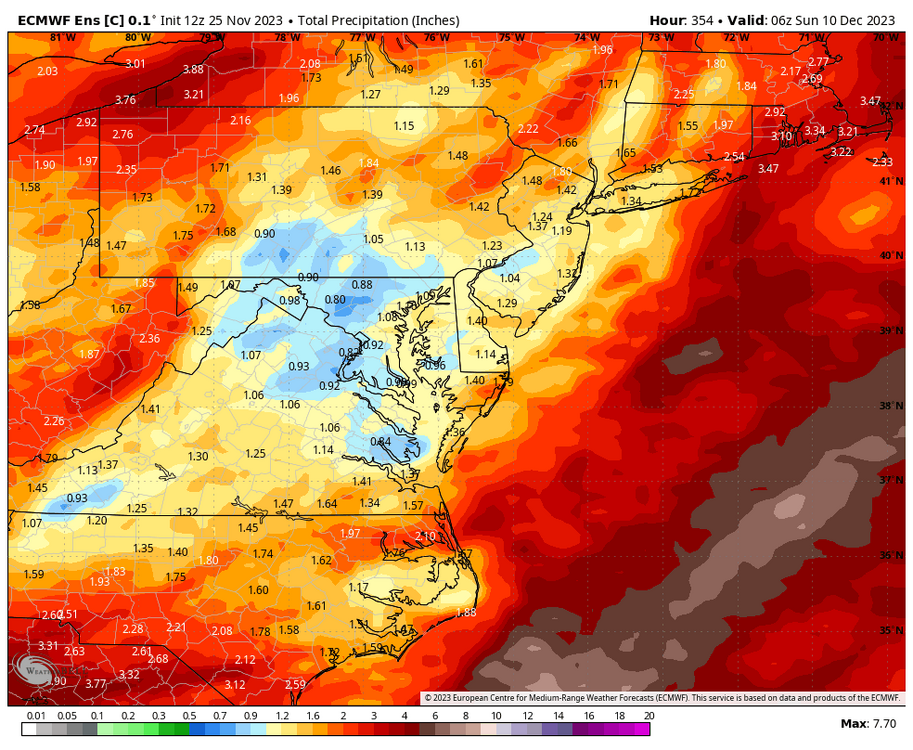
The latest from the Euro for the next 15 days does not look good:

-
Believe me that is a concern but last week was a good first step to climb out of that hole. 2" down and 8" excess to go for euphoria!
-
The GFS has developed the same bad trait as the Euro, but of course, what do we expect beyond 300 hrs..
-
Look at this on the 18 z Det. GFS!!
- 1,295 replies
-
- 4
-

-

-

-
- wishcasting
- almost winter
- (and 1 more)
-
A secondary thrust of very cold air will result in highs only in the upper 30's Tuesday and Wednesday for areas west of the BR.
- 1,295 replies
-
- 1
-
-
- wishcasting
- almost winter
- (and 1 more)
-
I received 2.10 inches of rain last Tuesday. This is wonderful but a fraction of what we need to bust the drought. 2 inches of rain cannot wipe out 10 - 15 inch deficits............................ Only a wet winter can solve our serious problems.
-
NO
-
That didn't last long.

- 1,295 replies
-
- 8
-
-
-
- wishcasting
- almost winter
- (and 1 more)
-
After a wonderful rain yesterday, the drought goon returns for the next 15 days.
- 1,295 replies
-
- 1
-

-
- wishcasting
- almost winter
- (and 1 more)
-
2.07" at my place, several stations in Charlottesville reported 4.0 - 4.5 inches!!
-
Very cold like 76-77 tends to be dry because southward suppression thrives in that pattern.
-
Sounds like 1957................................. Wow, that was 66 years ago!
-
1.25"........................... Most since July....................................
-
Yes, and that can be dangerous to those looking forward to a Nino wet winter. Which only happens 43% of the time in my locale.
-
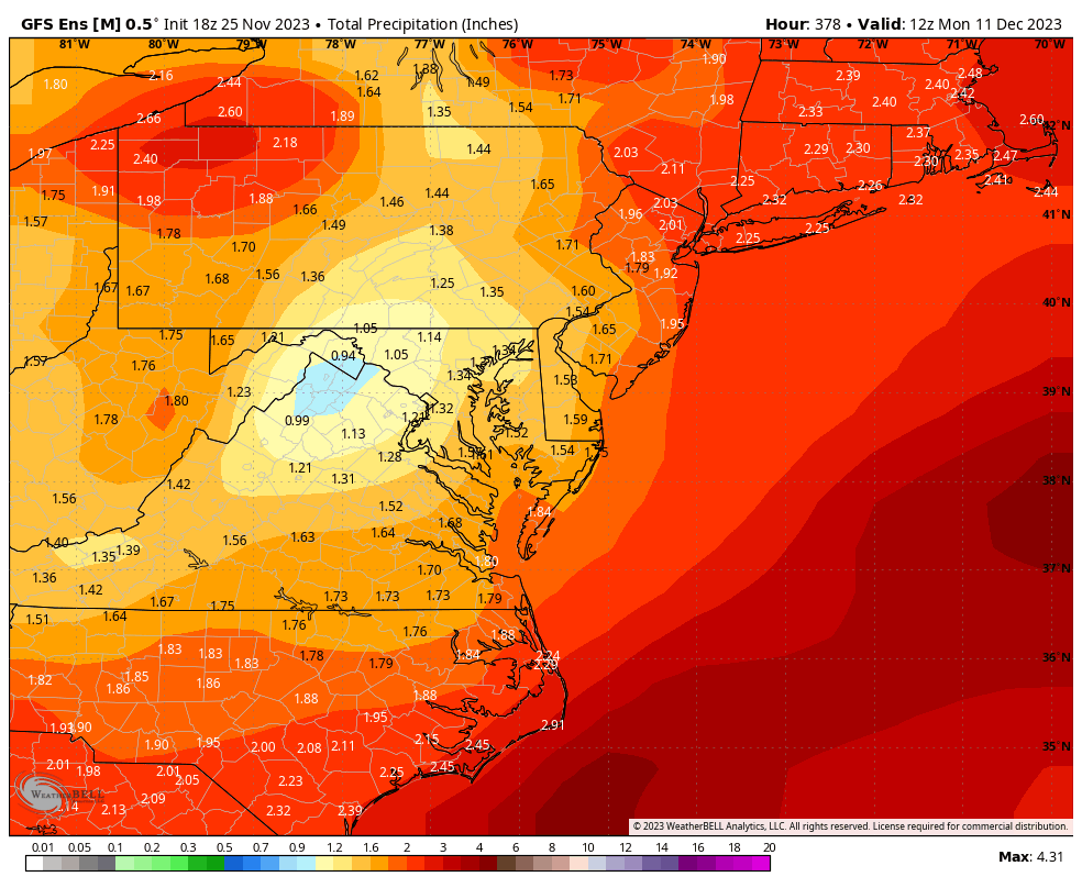
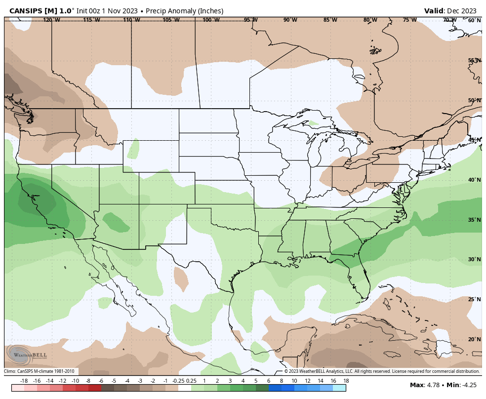
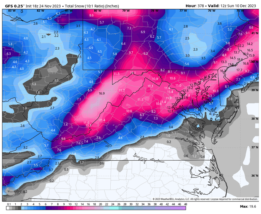
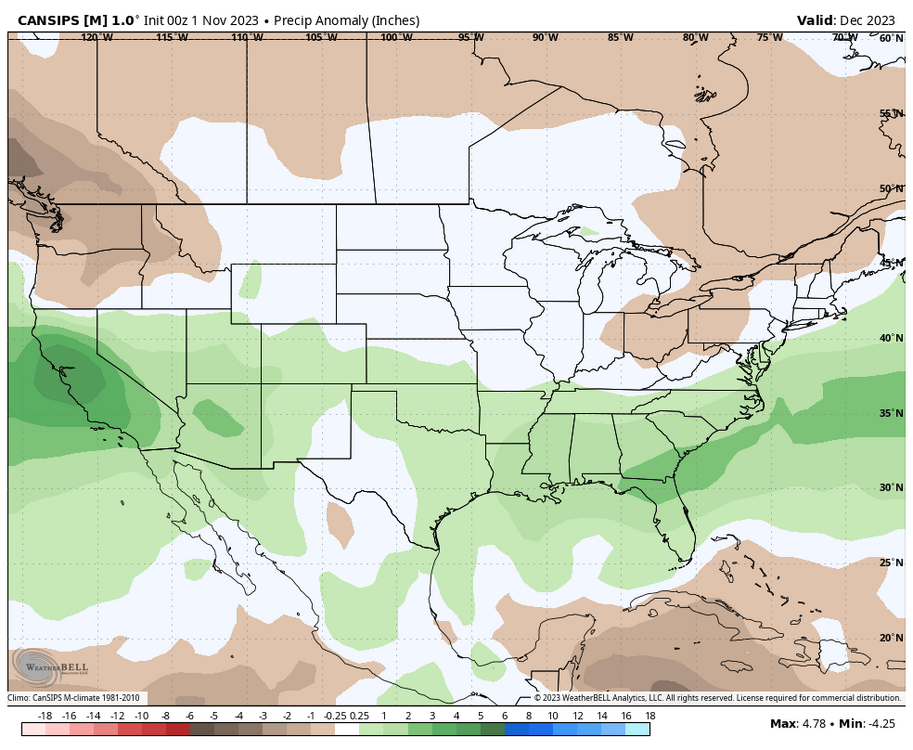
The latest CANSIPS paints that perfectly for December.
-
A little while ago I said that I would look at driest Nino winters since 1980 and snowfall for the Valley. The driest was 87-88 with 64% of normal precipitation (12.20"). I received 18 inches of snow which is 75% of normal snowfall for that winter.
- 1,295 replies
-
- 1
-
-
- wishcasting
- almost winter
- (and 1 more)
-
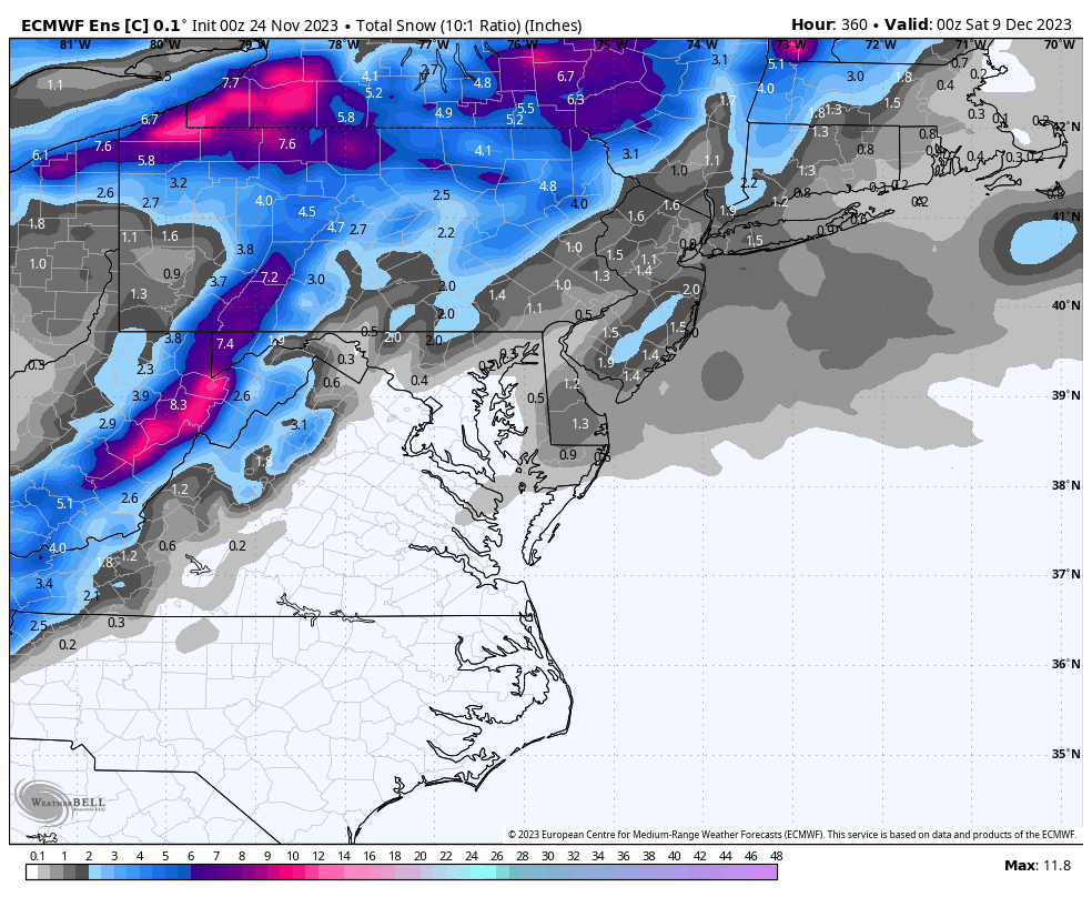
As I said Sunday morning, a few changes would give many in our region 4 - 8 inches of snow tomorrow. The NWS establishes a base of support with a WWA with the retreating cold air source and LP into the Ohio Valley. A terrible early season synoptic that chirps. https://forecast.weather.gov/showsigwx.php?warnzone=VAZ025&warncounty=VAC015&firewxzone=VAZ025&local_place1=4 Miles SSE Churchville VA&product1=Winter+Weather+Advisory&lat=38.1779&lon=-79.1425
-
22 degrees at 6 am.