stormy
-
Posts
2,111 -
Joined
-
Last visited
Content Type
Profiles
Blogs
Forums
American Weather
Media Demo
Store
Gallery
Everything posted by stormy
-
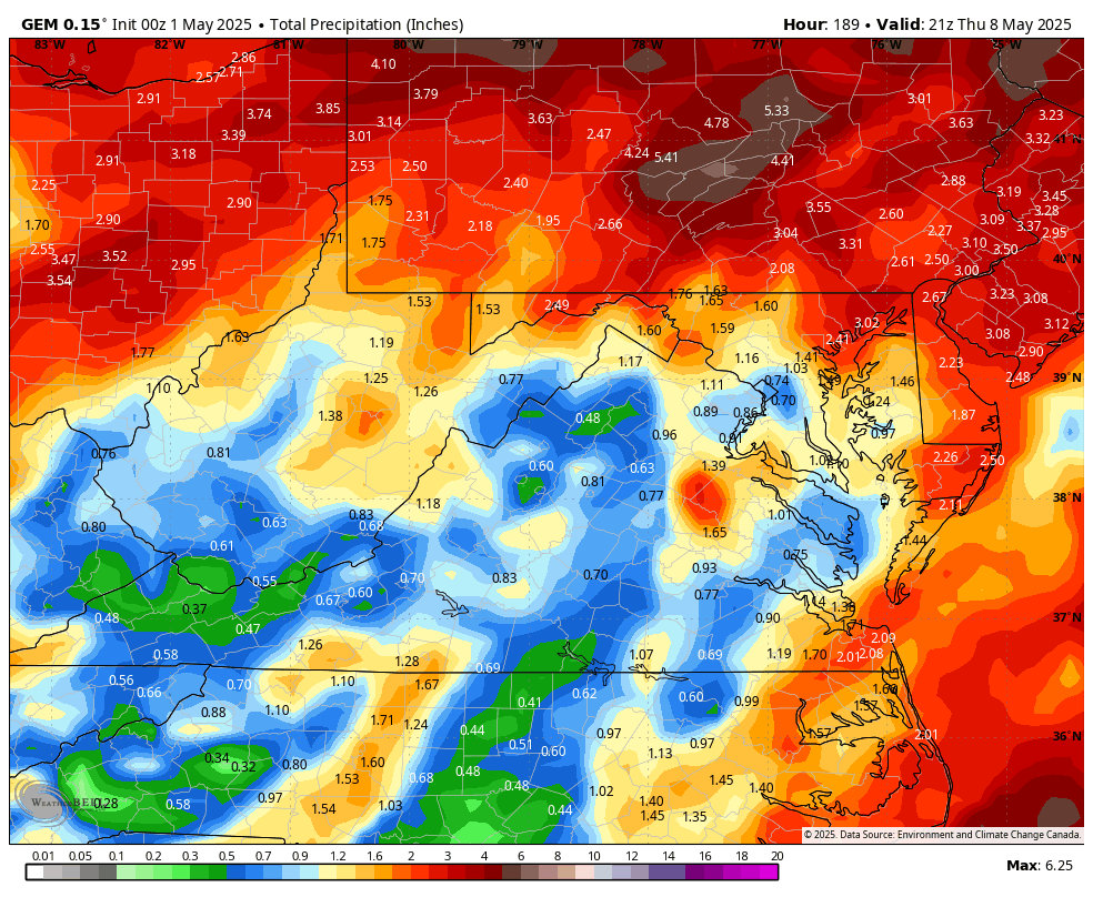
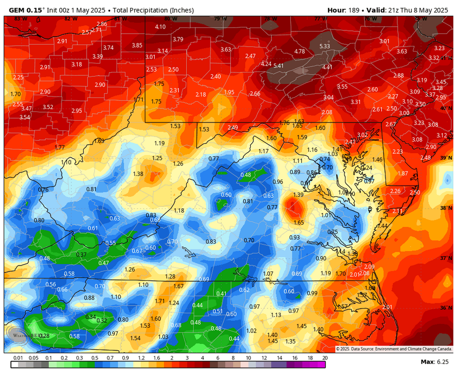
The 00z 5-1 GEM pushes the heavy rains north into Pennsylvania.
-
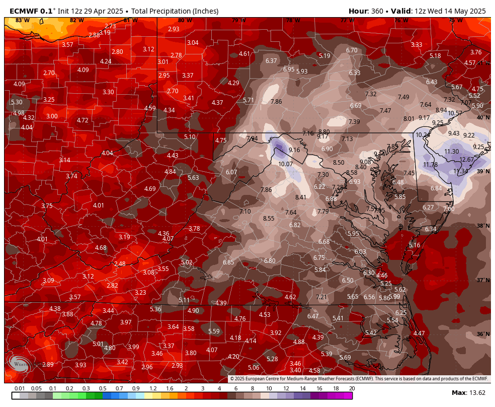
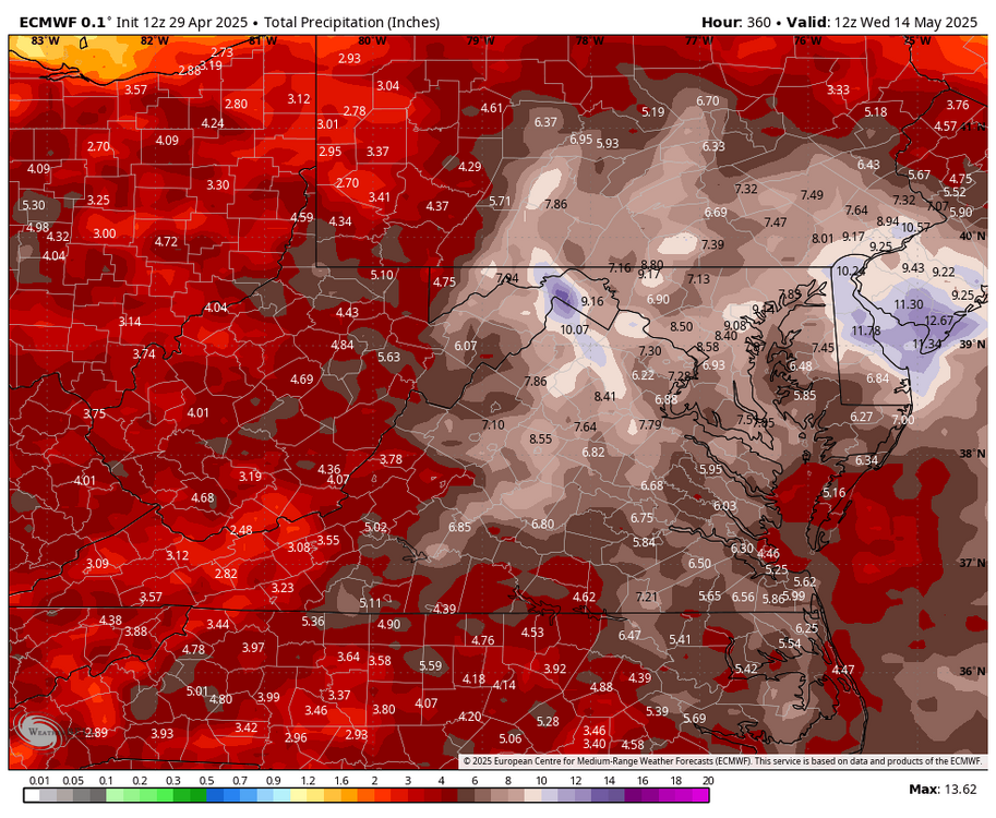
Precipitation is precipitation, winter or summer when looking 1 - 7 days into the future. The greater the expected sum total, the greater the error factor. The WPC has already changed significantly in the past 20 hrs. with qp amounts for the next 7 days.
-
The qp projections for next week will change at least 12 times in the next 6 days. What seems to be the sweet spot at this time will probably change during the next 48 hrs. Lets don't repeat the normal winter mistakes. The huge potential shift is that in conflict with usual patterns, low pressure surface and aloft will dominate instead of high pressure.
-
There are signals from different directions that we could turn wet from May 3 - May 13. Will it happen?? 30% probability.....................
-
This has a 10% chance of verification:
-
A frosty 30.3 this morning. This is 16 degrees colder than the 100 year historical average. Our frost free average date has increased to May 15 in the last 25 years. It used to be May 10.
-
This has a 40% chance of verification......................................
-
It has indeed. This dry tendency has persisted during Nina and Nino patterns.
-
March was very dry in Augusta with only 39% of normal rainfall. April has been dry with 66% of normal rainfall to date. The Extended GEFS and EURO Weeklies believe that May will continue the dry pattern, whatever that's worth!!
-
26.8 this morning. Another hard freeze.
-
37 mph gust this afternoon. Will calm by Thursday with hp overhead.
-
To our northwest, sparks are flying. The models generally say that activity wanes as it crosses the mountains. Will this be true????
-
27.5 this morning
-
In my area, all spring growth is dead from 21 degrees earlier this week This advisory useless.
-
The precipitation HOLE for western areas continues. .10" at 4:30
-
A total of .10" today. All the fire is to my east in the 95 corr.
-
21.8 this morning! All of my blooming peaches, cherries, plums and apples are frozen.
-
The 18z NAM paints high elevation snows for western areas Friday night. With a wrapped up system this is likely.
-
Agreed 100%. I am over 2 inches low for the past month! Thankfully, I have received .66" in the past 6 hrs.
-
10 inches of snow on April 12 would be quite a seasonal wrap-up. The GFS screams nor-easter blast!!!!!! Reminiscent of 9 inches on 4-7 -71..........................
-
Wow!!!! Nice, but believe it when you see it in the gauge.
-
1.31" of rain the first 28 days of March. That's only 37% of normal.............................
-
You're dwelling too much on Richmond. In December of 2024, Richmond was in moderate drought. Rainfall deficits have been a problem in the MA for 5 years now. The same anomaly contributes to the snow drought.
-
32 degrees this morning. 18 at Spruce Knob. One half to one inch of snow 30 - 100 miles northwest above 3000 ft.
-
A southeast ridge with the proper strength can funnel Gulf moisture our way. We can only hope.