stormy
-
Posts
1,500 -
Joined
-
Last visited
Content Type
Profiles
Blogs
Forums
American Weather
Media Demo
Store
Gallery
Everything posted by stormy
-
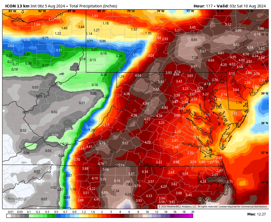
The NAM and ECMWF are both bouncing around quite a bit with the position of the center as the remnants move north across Va/WVa. The GFS and GEM are most consistent with the NHC up the Shenandoah Valley. Makes no difference, if the NHC general track verifies it will be wonderful! That would give western areas suffering tremendously from drought a multi-million dollar rain. Many millions of dollars worth of crops have already been lost. This will indeed be a God-Send for starving livestock who are also having water hauled in to them daily because ponds and streams that normally supply water are dried up. Hopefully, this will signal a change in the long term pattern.
-
NHC speeds up even more and shifts slightly west. Now, near Staunton at 8 am Friday.
-
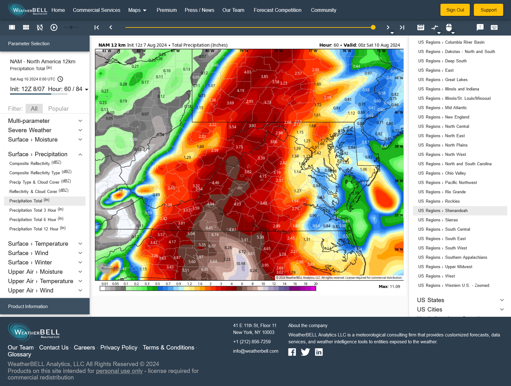
12z NAM 12 increases my total from 2.71" to 3.62".

-
My NBM total expectation has dropped from 4.73" at 8 pm to 3.84" now with a similar track close to my area. One possible factor is the NHC expected acceleration of the storm if this is modeled. The NHC expectation is now around 25mph as it moves north across Virginia.
-
NHC shifts the track 13 miles east at 5 am to Charlottesville at noon Friday. This is good because I was afraid the westward jog would continue. Ridge east and trough west will turn the trick.
-
Crozet at noon Friday from NHC which is 13 miles west of Charlottesville. 14 miles east of my east side deck with the Blue Ridge in the middle. Upslope enhancement should give 5 - 10 inches along the B.R. 3 - 6 inches in my back yard.
-
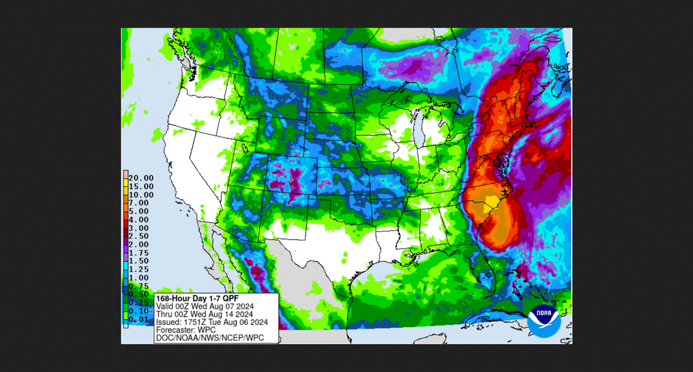
The WPC shifts the axis of heaviest rain to the west:
-
NAM 12 shifts west with 12z. Increased flood risk for western zones.
-
NHC shifts predicted track west overnight. 25 miles west of Richmond at midnight Friday. 20 miles southeast D.C. 2 am Saturday. My 3 model blend has increased from 3.76" at 6 pm to 4.96" at 7 am.
-
Some wonder about this model or that model???? That is nonsense. No model has the final solution yet. If they did it would be by pure accident.
-
The main question for the next 72 hrs. is exactly when and how strong will a mid level ridge build to the east of Debby. The strength of this ridge will determine whether Norfolk or Lynchburg will receive heavy rain.
-
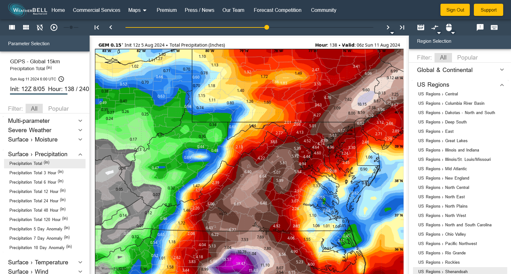
Latest GEM gives me nearly 7 inches! Bring it on!!!!!!! My stream needs a good flushing. It has been nearly 5 years.

-
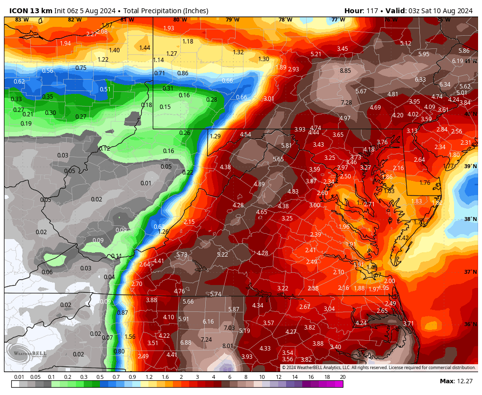
GFS finally abandons that westward jog, as I expected. ICON nails the ideal track for drought stricken areas..
-
I'm still waiting for confusion to clear up hopefully tomorrow. We still have the deterministic models a thousand miles apart. The ensembles are the best at this point for a much needed soaking rain. A triple blend of the CMC, GEFS and ECM ens give me 3.01" through Saturday. The deterministic 3 give me a blend of 2.06".
-
You are exactly right! This is a sad commentary on the world that we live in.
-
I absolutely did not say that NHC is not doing a good job. A definition of confusion is "lack of understanding or uncertainty". They admit with the 5 am discussion that the future and intensity north of Florida is "low confidence". A pure understanding of "low confidence" is uncertainty, therefore confusion of track north of Florida. Certainty would create high confidence. That is not possible at this time. This is not a deficiency of performance by NHC. This is honesty based on very erratic model data. I expect better model agreement by tomorrow.
-
Honestly, total confusion with the models and NHC. Should have a better handle by Monday or Tuesday.
-
I have high hopes but will only believe it when it's in the gauge. Of course, this extreme drought has to break at some point. It might as well snap next week. 2021 is my driest first 7 months in the past 40 years with 17.37", followed closely by 2002 at 18.05"and this year at 18.80".
-
My goodness! I feel blessed with 3.31" since Memorial Day.
-
Historically, dry summers can produce snowy winters!!!! 86-87 summer was very dry, yet produced 52 inches of snow the following winter................... But, the pattern has too change to more qp...............................
-
Approach during the past hour of a line. 10 drops and 33 mph S.W. gusts. .02 rain. If we don't evolve to a more normal pattern before November, speculation on winter snowfall will be a point specific ludicrous venture. Winter precip. patterns can always change. We can only Pray.........................
-
I love low 70's vs low 90's late next week but would much rather see Debby remnants parked over Lynchburg instead of Nashville!
-
Chuck, you're very lucky if your dry streak "came out of nowhere". I have been very dry since May.
-
68/67 Pops drop from 70% to 30% for today.......................... Maybe now we'll get some rain...........................
-
88/68......................... A glorious total of 1.86" rain for July compared to a normal of 4.44" 42% of normal................ Oh well, that is better than some of our winter snowfall in the last few years. And, better than the 40% of normal rainfall for June!!!!!!!!!!!!!!!!!!!!!