stormy
-
Posts
2,117 -
Joined
-
Last visited
Content Type
Profiles
Blogs
Forums
American Weather
Media Demo
Store
Gallery
Everything posted by stormy
-
Regarding the Sunday - Wed potential, the physics based models have been playing hopscotch. The AI models have been amazingly consistent with a recent uptick in expectations. AI and AI ens have scored Augusta with a blend of 1.20" since 12z Thursday. The latest run has increased to 1.40".
-
51.6 this morning. Depth, orientation and slow movement of ULL over OV in opposition to HP off the coast will determine who gets how much rain from Sunday - Tuesday. We need to start August as a wet month! I have only received 62% of normal for July.
-
Historically, there are wet Nino summers and historically there are dry Nino summers. Strong Nino's (greater than =1.0) almost always create a cold season robust subtropical jet which usually favors a wet cold season (mid October through February.) Richmond has a higher probability of a wet winter than Staunton or Winchester, 80/60. D.C. comes in at about 70%.
-
I wish today's weather could linger into September before beginning to cool down a little. Cloudy and 72 with a southerly breeze at 4.
-
57 and cloudy this morning. No radiational cooling.
-
65 with a northeast breeze 5 - 15. Feels like fall! Spruce Knob, 46.
-
I feel your pain.
-
.70" at my place. Weyers Cave 1.03"
-
Human forecasters act as the ultimate decision-makers in formulating a forecast. AI and advanced computer modeling are certainly incorporated into the process but humans provide oversight to any and all forecasts.
-
The luck of the draw also dealt me a losing hand yesterday but this was a model loser since Thursday, therefore, I was not surprised. NWS high probs. really don't count anymore. Monterey received .92" and Marlinton W.Va. got 1.59".
-
Hello again! Nice to hear from you!! I'm happy to give your comment the respect that it deserves. I'm not joking. First two sentences: I'm not concerned about events. Their not supremely important. I'm talking about the millions who work and or play outside. Back in the seventies, the best way to be fired from your job was to call your supervisor and say, I'm not going to work today or the rest of the week because the air is too dirty. Those who had been trapped in an office all day looked forward to being outside in the fresh air for an evening softball game. Some of those who worked and played in all that dirty air have lived to be over 100 years old. Last sentence: Now we know better. Do we really? I'm good friends with a person who will receive major surgery next week. Visiting and receiving phone pre-surgery guidance from about 6 people from the hospital during the past week was a roller coaster of contradictory advice. About 4 people directly gave about 25 do's and dont's. The other 2 directly contradicted some of the guidance from the first 4. Who was correct??? Watch out for those high winds later today. The SPC really enhances the threat around D.C. compared to Augusta County. Otherwise, enjoy your day.
-
Wisdom often comes with age compared to simpletons still wet behind the ears. Be patient, you will arrive at the wisdom stage much sooner than you think.
-
91 at 4:30 is no big deal. AQI compared to 50 years ago averages in July is also no big deal.
-
66.2 is the warmest morning of the week.
-
I recorded a refreshing 62 at 6:45.
-
90/62 here in Augusta.
-
Wind-shear and African Dust have killed the Atlantic Tropical season.
-
.11" rain yesterday and .85" for the week. Green grass abounds.
-
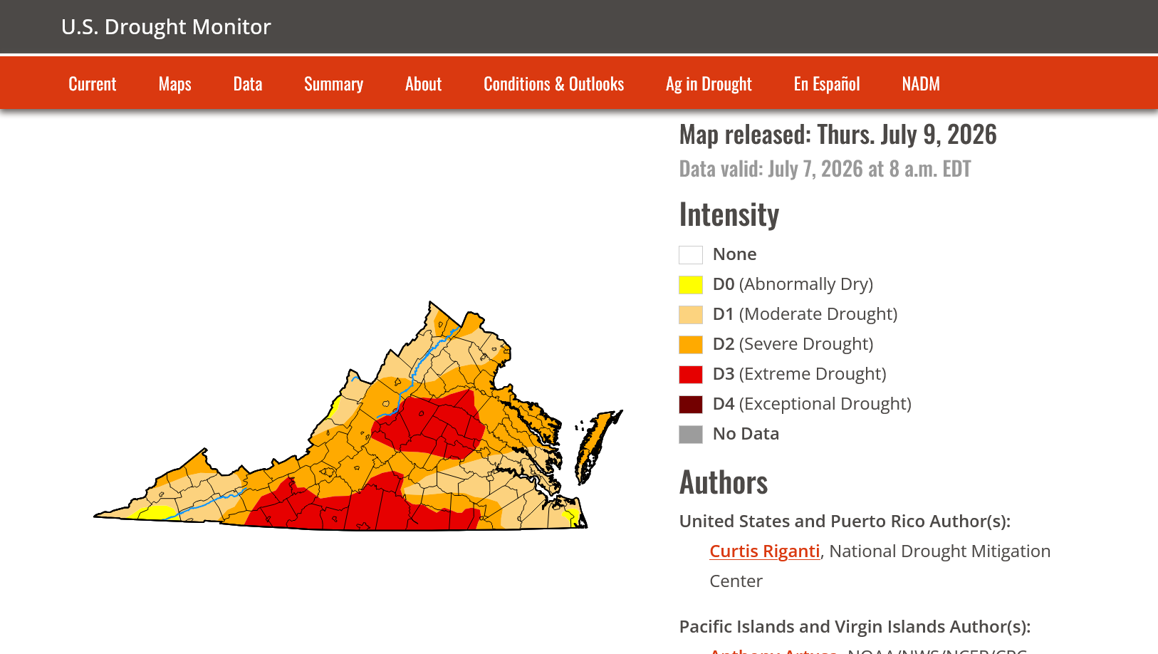
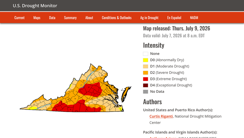
Thank you! I do appreciate your interest in this. I have followed the Drought Monitor closely for years and have had faith in its veracity until in recent months. I closely monitor water and soil conditions for some rather large agricultural interests, both topsoil and underground water table. Back in late February when our Augusta water table was 21 ft. below normal, the U.S. Drought Monitor placed Augusta in moderate drought. In late June when our water table had recovered to only 2 ft. below normal after a very wet May, the drought Monitor placed us in severe to Extreme Drought. Go figure On May 19, Augusta was all extreme. Northern Va. was all severe. On June 30, most of northern Va. down to central Rockingham had been downgraded to moderate drought. Augusta was and remains in severe to extreme. I can no longer trust the U.S. Drought Monitor as a reliable source of information.
-
Augusta County is mostly green and growing. My lawn looks quite lush and green for nearly mid July. The U.S. Drought Monitor has not changed since June 1 and keeps Augusta in Severe to Extreme Drought. Truly amazing.
-
Another .53" this late afternoon! Fishersville received 2.24..
-
I received .15 but there is a report east of New Hope of 1.18". A friend driving thru that area said ditches were full.
-
.10" yesterday evening. Staunton was under a Warning for about 30 minutes. West-side received around 2.00".
-
.75" so far. Temp. down to 70.
-
.22" more in a torrential short shower 4:05. Temperature down to 79!