.webp.70c18861c39c8ef8c4811e598978da45.webp)

CurlyHeadBarrett
-
Posts
827 -
Joined
-
Last visited
Content Type
Profiles
Blogs
Forums
American Weather
Media Demo
Store
Gallery
Everything posted by CurlyHeadBarrett
-
12z HWRF finally drops the EWRC-prone structure and shows a much better core structure as it bombs 98L out to the mid-930s on Thursday. It shows the system passing over/near the Virgin Islands/PR as a TS and organizes once it gets north of their latitude. i love it
-
12z HWRF finally drops the EWRC-prone structure and shows a much better core structure as it bombs 98L out to the mid-930s on Thursday. It shows the system passing over/near the Virgin Islands/PR as a TS and organizes once it gets north of their latitude.
-
-
-
My favorite city to visit
-
Mumbai or Brampton
-
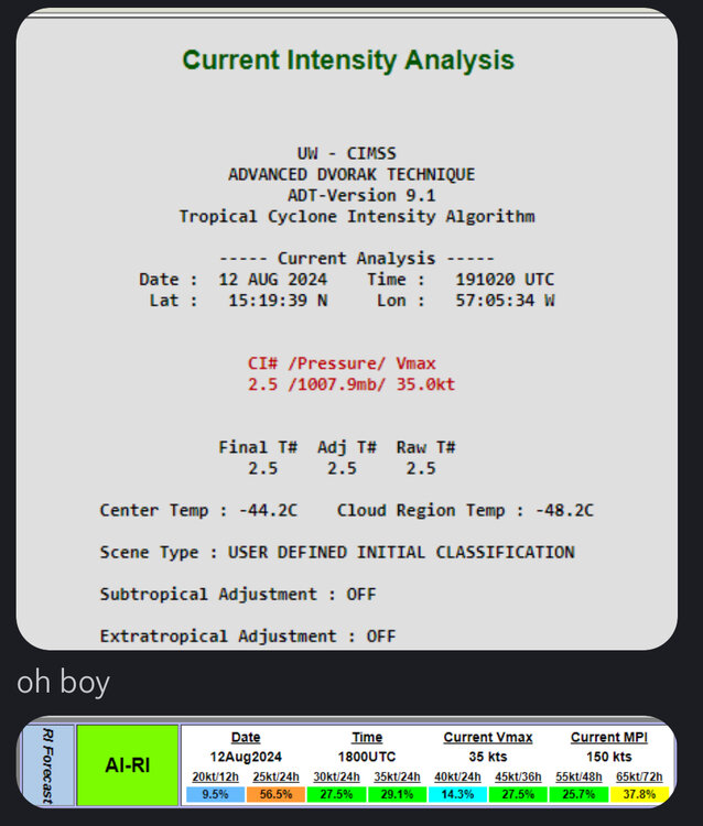
Tropical Storm FIVEAs of 18:00 UTC Aug 12, 2024: Location: 16.1°N 56.6°WMaximum Winds: 35 kt Gusts: N/AMinimum Central Pressure: 1008 mbEnvironmental Pressure: N/ARadius of Circulation: N/ARadius of Maximum wind: 40 nm34 kt Wind Radii by Quadrant:
-
Tropical Storm FIVEAs of 18:00 UTC Aug 12, 2024: Location: 16.1°N 56.6°WMaximum Winds: 35 kt Gusts: N/AMinimum Central Pressure: 1008 mbEnvironmental Pressure: N/ARadius of Circulation: N/ARadius of Maximum wind: 40 nm34 kt Wind Radii by Quadrant:
-
AL, 05, 2024081218, , BEST, 0, 161N, 566W, 35, 1008, TS, 34, NEQ, 50, 0, 0, 0, 1012, 150, 40, 0, 0, L, 0, , 0, 0, FIVE, S, 0, , 0, 0, 0, 0, genesis-num, 013,
-
AL, 05, 2024081218, , BEST, 0, 161N, 566W, 35, 1008, TS, 34, NEQ, 50, 0, 0, 0, 1012, 150, 40, 0, 0, L, 0, , 0, 0, FIVE, S, 0, , 0, 0, 0, 0, genesis-num, 013,
-
Active Systems: The National Hurricane Center is issuing advisories on Potential Tropical Cyclone Five, located a few hundred miles east of the Leeward Islands. * Formation chance through 48 hours...high...near 100 percent. * Formation chance through 7 days...high...near 100 percent.
-
mirin, also Active Systems: The National Hurricane Center is issuing advisories on Potential Tropical Cyclone Five, located a few hundred miles east of the Leeward Islands. * Formation chance through 48 hours...high...near 100 percent. * Formation chance through 7 days...high...near 100 percent.
-
Gonzalo reincarnate or Gonzalo in mumbai?
-
Fabian reincarnate? Gonzalo brother?
-
chomp chomp https://www.tropicaltidbits.com/analysis/models/hwrf-p/2024081206/hwrf-p_satIR_05L_18.png
-
chomp chomp https://www.tropicaltidbits.com/analysis/models/hwrf-p/2024081206/hwrf-p_satIR_05L_18.png
-
GFS has Ernesto being born around the 14th or so. At the end of the run (8/28) it's still a hurricane and still doing loop-the-loops in the north Atlantic. Year of the long trackers.
-
GFS has Ernesto being born around the 14th or so. At the end of the run (8/28) it's still a hurricane and still doing loop-the-loops in the north Atlantic. Year of the long trackers.
-
rate the new cone
-
rate the new cone
-
-
-
mirin the 40kt sfmr https://www.tropicaltidbits.com/recon/recon_NOAA3-0105A-INVEST_timeseries.png
-
mirin the 40kt sfmr https://www.tropicaltidbits.com/recon/recon_NOAA3-0105A-INVEST_timeseries.png
-
same, who knows buddy boyo