Tropical Storm Ernesto Discussion Number 7
NWS National Hurricane Center Miami FL AL052024
500 AM AST Tue Aug 13 2024
Satellite imagery and French radar data from Guadeloupe indicate
that convection has become more concentrated near the center of
Ernesto during the past several hours, and there is increased
evidence of cyclonic rotation in the radar imagery. However, this
has not yet resulted in significant intensification, with surface
obs from the Leeward Islands showing a large area of pressures near
1007-1009 mb and no evidence of any tight wind center. Based on
this and the latest satellite intensity estimates, the initial
intensity is held at 35 kt.
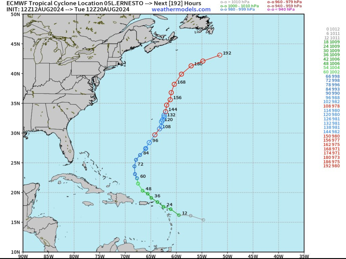
The initial motion is a somewhat uncertain 280/17, a little slower
than before. Ernesto should turn west-northwestward with an
additional decrease in forward speed during the next 12 h or so as
it approaches a developing break in the subtropical ridge. This
motion should bring the center near or over the Leeward Islands
today and near or over the Virgin Islands and Puerto Rico tonight
and early Wednesday. After that, the flow between the subtropical
ridge and a mid-latitude trough moving eastward from the United
States should cause the cyclone to turn northward and northeastward.
By the end of the forecast period, this trough is expected to move
eastward away from Ernesto, with a mid-latitude shortwave ridge
passing north of the storm. This development should cause another
decrease in forward speed during the 96-120 h period. The new
forecast track is close to the various consensus models, and it is
also similar to the previous forecast track.
Ernesto is forecast to be in an environment of light to moderate
shear and over warm sea surface temperatures through the forecast
period, and this combination should allow it to strengthen.
Intensification is likely to be slow during the first 12-24 h
primarily due to the current lack of organization. After that, a
faster rate of strengthening is expected, with Ernesto forecast to
reach hurricane strength in 36-48 h. The intensity forecast
follows the overall trend of the intensity guidance, and it lies
between the intensity consensus and the upper edge of the guidance.
Key Messages:
1. Ernesto is expected to bring tropical storm conditions to
portions of the Leeward Islands today and to the Virgin Islands and
Puerto Rico by late today or tonight. Tropical Storm Warnings are
in effect for this entire area.
2. Heavy rainfall may result in locally considerable flash flooding
and mudslides in areas of the Leeward Islands through today, and
over the Virgin Islands into Puerto Rico by later today through
Wednesday.
3. It is too soon to know what impacts Ernesto could bring to
Bermuda late this week, and interests there should monitor the
progress of this system.
FORECAST POSITIONS AND MAX WINDS
INIT 13/0900Z 16.2N 61.3W 35 KT 40 MPH
12H 13/1800Z 17.1N 63.4W 40 KT 45 MPH
24H 14/0600Z 18.7N 65.7W 50 KT 60 MPH
36H 14/1800Z 20.7N 67.3W 60 KT 70 MPH
48H 15/0600Z 23.0N 68.3W 70 KT 80 MPH
60H 15/1800Z 25.1N 68.3W 80 KT 90 MPH
72H 16/0600Z 27.2N 67.3W 90 KT 105 MPH
96H 17/0600Z 30.5N 65.0W 95 KT 110 MPH
120H 18/0600Z 33.5N 64.5W 95 KT 110 MPH
$$
.webp.70c18861c39c8ef8c4811e598978da45.webp)