.webp.70c18861c39c8ef8c4811e598978da45.webp)

CurlyHeadBarrett
-
Posts
827 -
Joined
-
Last visited
Content Type
Profiles
Blogs
Forums
American Weather
Media Demo
Store
Gallery
Everything posted by CurlyHeadBarrett
-
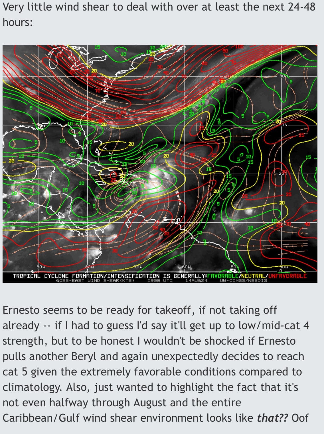
Today's 06z models are still very bullish. No tales from Mumbai loonyland here. ICON: 944 mb at 108 hrs, probably a cat 4. HWRF: 948 mb at 60 hrs with peak winds of 108 kt, a strong cat 3. HMON: 955 mb at 51 hrs with peak winds of 116 kt, a cat 4. HAFS-A: 947 mb at 108 hrs with peak winds of 109 kt, a strong cat 3. Intensification is much more gradual though. HAFS-B: 957 mb at 48 hrs with peak winds of 110 kt, a strong cat 3. These models together would blend to a high-end cat 3 or low-end cat 4 hurricane (around 950 mb / 113 kt assuming ICON's 944 mb would result in ~120 kt).
-
Could Brampton, ON be affected?
-
What happened
-
-
What’s a specific h5 setup
-

-

2024 Atlantic Hurricane Season
CurlyHeadBarrett replied to Stormchaserchuck1's topic in Tropical Headquarters
Tales from mumbai it will explode soon just you wait -
In other words humberto reincarnate
-
Fuaaaark, now forecast to become a major. Mirin brah. DNRD (Didn't Read): Tropical Storm Ernesto passed over the Virgin Islands and is heading northwest, likely impacting Puerto Rico and Bermuda soon. Current Status: Wind speeds at 65 mph; expected to strengthen to a major hurricane by Friday. Key Concerns: Tropical storm conditions in the Virgin Islands and Puerto Rico through early Wednesday; possible hurricane conditions in some areas. Heavy rainfall could lead to flash flooding and mudslides. Bermuda may see impacts by late week; stay alert. Dangerous swells affecting several Caribbean regions and will reach the U.S. East Coast and Bermuda by the weekend. Forecast: Ernesto is expected to strengthen over the next few days, reaching up to 115 mph winds before weakening slightly. FORECAST POSITIONS AND MAX WINDS INIT 14/0300Z 18.8N 65.3W 55 KT 65 MPH 12H 14/1200Z 20.3N 66.7W 65 KT 75 MPH 24H 15/0000Z 22.4N 68.3W 80 KT 90 MPH 36H 15/1200Z 24.4N 68.8W 90 KT 105 MPH 48H 16/0000Z 26.3N 68.3W 95 KT 110 MPH 60H 16/1200Z 28.1N 67.2W 100 KT 115 MPH 72H 17/0000Z 29.9N 66.2W 100 KT 115 MPH 96H 18/0000Z 34.0N 64.5W 90 KT 105 MPH 120H 19/0000Z 38.0N 63.0W 85 KT 100 MPH
-
Remember Debby's sat appearance?
-
How much did Ernesto's brothers Gonzalo and Humberto do
-
This isn't Mumbai
-
-
Giving me debby FLASHEDbacks
-
What do you think buddy boyo?
-
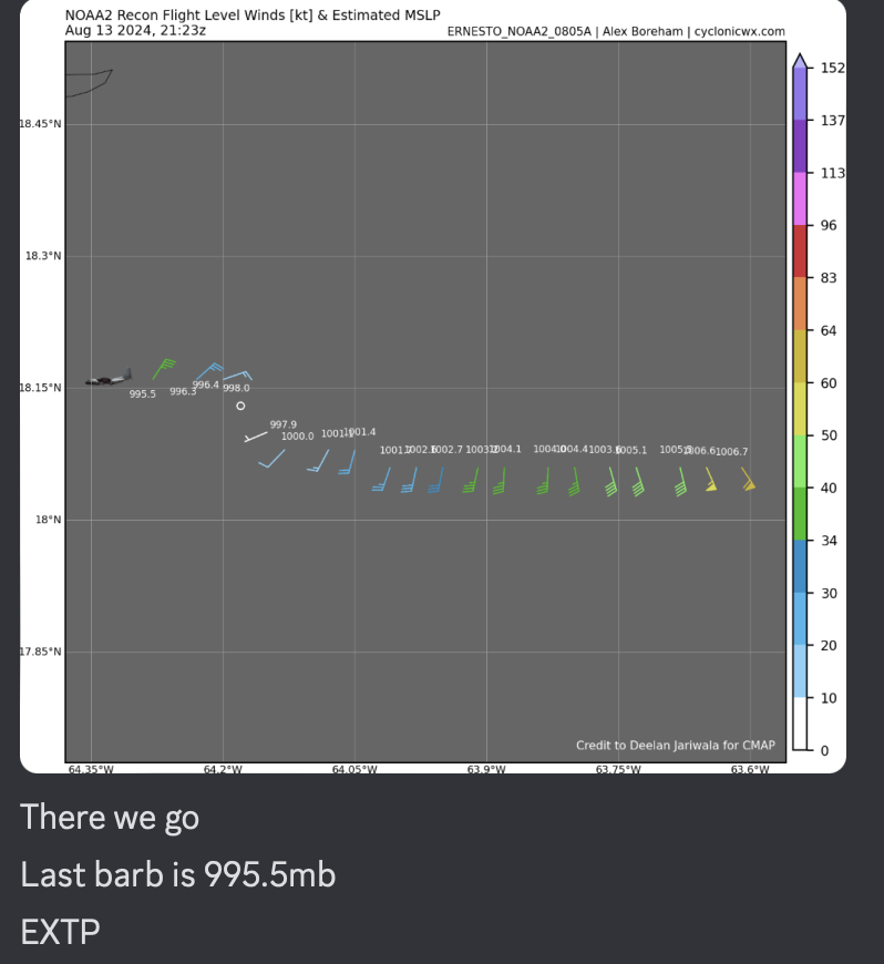
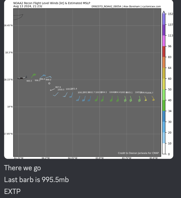
LOCATION...18.4N 64.7WABOUT 20 MI...30 KM E OF ST. THOMASABOUT 90 MI...145 KM E OF SAN JUAN PUERTO RICOMAXIMUM SUSTAINED WINDS...65 MPH...100 KM/HPRESENT MOVEMENT...WNW OR 300 DEGREES AT 18 MPH...30 KM/HMINIMUM CENTRAL PRESSURE...998 MB...29.47 INCHES
-
tales from mumbai
-
2024 Atlantic Hurricane Season
CurlyHeadBarrett replied to Stormchaserchuck1's topic in Tropical Headquarters
How tf did this come out so early https://www.nhc.noaa.gov/data/tcr/AL032024_Chris.pdf -
When the coping is too strong
-
JFL at this. The storm is organizing very well
-
No problem bhai
-
Could we see a hurricane near Greenland?
-
Could Ernesto make a landfall in a weird location like Greenland or could he recurve into Iberia?
-
-