.webp.70c18861c39c8ef8c4811e598978da45.webp)

CurlyHeadBarrett
-
Posts
827 -
Joined
-
Last visited
Content Type
Profiles
Blogs
Forums
American Weather
Media Demo
Store
Gallery
Everything posted by CurlyHeadBarrett
-

2024 Atlantic Hurricane Season
CurlyHeadBarrett replied to Stormchaserchuck1's topic in Tropical Headquarters
Define "more modest" -
Central & Eastern Pacific Thread
CurlyHeadBarrett replied to Windspeed's topic in Tropical Headquarters
Bro wtf is up with that name -
of course bhai
-
Central & Eastern Pacific Thread
CurlyHeadBarrett replied to Windspeed's topic in Tropical Headquarters
jova for gilma. Maybe she can get another C3 peak? -
Tales from the Mumbai asylum
-
Central & Eastern Pacific Thread
CurlyHeadBarrett replied to Windspeed's topic in Tropical Headquarters
it's over shear mogged her -
Central & Eastern Pacific Thread
CurlyHeadBarrett replied to Windspeed's topic in Tropical Headquarters
nah she mogs that category 4 expected -
2024 Atlantic Hurricane Season
CurlyHeadBarrett replied to Stormchaserchuck1's topic in Tropical Headquarters
Jova for bears, pack it up, the models are lighting up -
Central & Eastern Pacific Thread
CurlyHeadBarrett replied to Windspeed's topic in Tropical Headquarters
125mph -
2024 Atlantic Hurricane Season
CurlyHeadBarrett replied to Stormchaserchuck1's topic in Tropical Headquarters
Same here tbh. -
Central & Eastern Pacific Thread
CurlyHeadBarrett replied to Windspeed's topic in Tropical Headquarters
jfl she is now a c2: 2:00 PM PDT Wed Aug 21 Location: 16.3°N 123.2°W Moving: WNW at 7 mph Min pressure: 972 mb Max sustained: 105 mph CAGED HARD AT THIS, JFL. Broooooootal for ernesto What do you think? C3 seems reasonable tbh I'm thinking it's neutral TBH -
Central & Eastern Pacific Thread
CurlyHeadBarrett replied to Windspeed's topic in Tropical Headquarters
c4 peak sheeeit FORECAST POSITIONS AND MAX WINDS INIT 21/2100Z 16.3N 123.2W 90 KT 105 MPH 12H 22/0600Z 16.6N 124.0W 105 KT 120 MPH 24H 22/1800Z 16.9N 125.2W 115 KT 130 MPH 36H 23/0600Z 17.1N 126.4W 110 KT 125 MPH 48H 23/1800Z 17.4N 127.8W 105 KT 120 MPH 60H 24/0600Z 17.6N 129.3W 100 KT 115 MPH 72H 24/1800Z 17.7N 131.0W 95 KT 110 MPH 96H 25/1800Z 18.0N 134.6W 85 KT 100 MPH 120H 26/1800Z 18.5N 138.6W 75 KT 85 MPH -
Central & Eastern Pacific Thread
CurlyHeadBarrett replied to Windspeed's topic in Tropical Headquarters
Moggity mog Hurricane GILMA As of 18:00 UTC Aug 21, 2024: Location: 16.2°N 122.9°W Maximum Winds: 90 kt Gusts: N/A Minimum Central Pressure: 972 mb Environmental Pressure: N/A Radius of Circulation: N/A Radius of Maximum wind: 10 nm -
Central & Eastern Pacific Thread
CurlyHeadBarrett replied to Windspeed's topic in Tropical Headquarters
EP, 07, 2024082118, , BEST, 0, 162N, 1229W, 90, 972, HU -
Central & Eastern Pacific Thread
CurlyHeadBarrett replied to Windspeed's topic in Tropical Headquarters
@n9wiffWE HAVE A MOGGER (GILMA) EVOLVING. MUH CATEGORY 1 definitely a category 2-3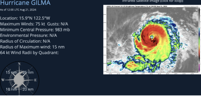
-
Central & Eastern Pacific Thread
CurlyHeadBarrett replied to Windspeed's topic in Tropical Headquarters
muh category 1 https://i.imgur.com/02l32vB.mp4 GILMA MOGS -
Central & Eastern Pacific Thread
CurlyHeadBarrett replied to Windspeed's topic in Tropical Headquarters
Bro tf is happening with gilma -
Oh yes gilma the donut.
-
Could we get a Greenland landfall?
-
WTF is this
-
-
If the hurricane models are right, Ernesto should have until midday or early afternoon tomorrow to continue intensifying. However, none of the 18z models have properly initialized Ernesto’s current structure. The HAFS-B gets the closest and shows a 100-105 kt Cat 3 peak tomorrow.
-
HURRICANE AGAIN JFL AL, 05, 2024081818, , BEST, 0, 364N, 627W, 65, 977, HU
-
wouldn't be surprised if this makes one last run for C2, especially with its smaller RMW and otherwise favorable conditions
-
Shit that’s low inhib asf T levels?


