.webp.70c18861c39c8ef8c4811e598978da45.webp)

CurlyHeadBarrett
-
Posts
827 -
Joined
-
Last visited
Content Type
Profiles
Blogs
Forums
American Weather
Media Demo
Store
Gallery
Everything posted by CurlyHeadBarrett
-
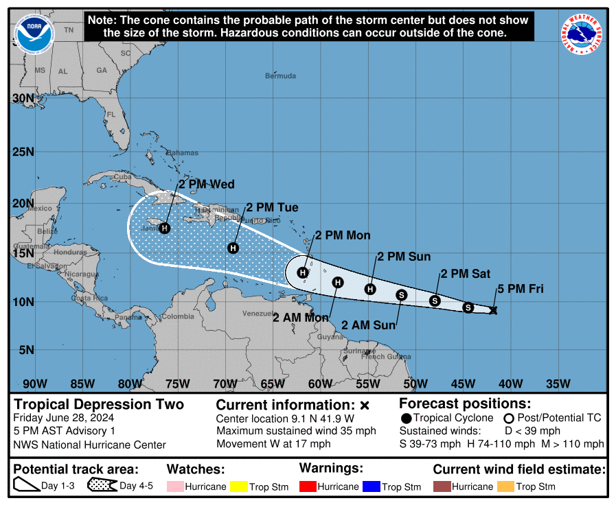
 JFL AT BERYL WHAT THE HELL IS THIS ALREADY ...BERYL STRENGTHENING... ...EXPECTED TO BECOME A HURRICANE BEFORE IT REACHES THE WINDWARD ISLANDS... 8:00 AM AST Sat Jun 29 Location: 9.8°N 46.8°W Moving: W at 21 mph Min pressure: 999 mb Max sustained: 60 mph
 -
Beryl might unironically mog the SAL
-
Beryl: Good morning, do I mog?
-
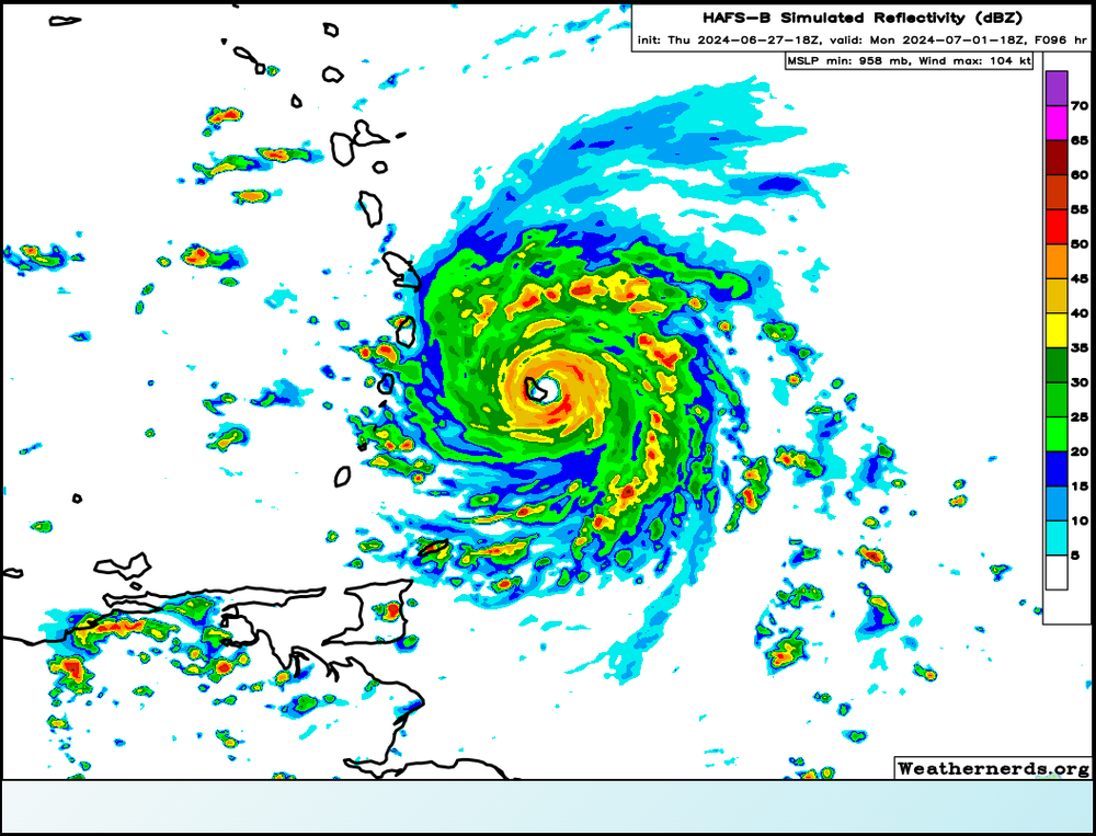
mogs me ngl FORECAST POSITIONS AND MAX WINDS INIT 29/0300Z 9.3N 43.6W 35 KT 40 MPH 12H 29/1200Z 9.7N 46.2W 40 KT 45 MPH 24H 30/0000Z 10.4N 49.7W 50 KT 60 MPH 36H 30/1200Z 11.0N 53.1W 60 KT 70 MPH 48H 01/0000Z 11.7N 56.5W 70 KT 80 MPH 60H 01/1200Z 12.5N 60.0W 80 KT 90 MPH 72H 02/0000Z 13.6N 63.6W 90 KT 105 MPH 96H 03/0000Z 16.0N 71.0W 90 KT 105 MPH 120H 04/0000Z 17.8N 77.8W 80 KT 90 MPH $$ Forecaster Kelly
-
What a mogger ...DEPRESSION STRENGTHENS INTO TROPICAL STORM BERYL... ...EXPECTED TO STRENGTHEN INTO A HURRICANE AS IT APPROACHES THE WINDWARD ISLANDS... SUMMARY OF 1100 PM AST...0300 UTC...INFORMATION ----------------------------------------------- LOCATION...9.3N 43.6W ABOUT 1110 MI...1785 KM ESE OF BARBADOS MAXIMUM SUSTAINED WINDS...40 MPH...65 KM/H PRESENT MOVEMENT...W OR 275 DEGREES AT 18 MPH...30 KM/H MINIMUM CENTRAL PRESSURE...1006 MB...29.71 INCHES
-
2024 Atlantic Hurricane Season
CurlyHeadBarrett replied to Stormchaserchuck1's topic in Tropical Headquarters
Ouch -
JFL at TROPICAL TIDBITS Tropical Storm BERYL As of 00:00 UTC Jun 29, 2024: Location: 9.2°N 42.7°W Maximum Winds: 35 kt Gusts: N/A Minimum Central Pressure: 1006 mb Environmental Pressure: N/A Radius of Circulation: N/A Radius of Maximum wind: 40 nm 34 kt Wind Radii by Quadrant: AL, 02, 2024062900, , BEST, 0, 92N, 427W, 35, 1006, TS, 34, NEQ, 40, 0, 0, 40, 1011, 150, 40, 0, 0, L, 0, , 0, 0, BERYL, M, 0, , 0, 0, 0, 0, genesis-num, 008,
-
Dennis and Emily first official forecast for comparison https://x.com/VortixWx/status/1806792419813237062
-
uptrending mogger alert
-
too many hurricanes on hurricane HGH and doing the hurricane equivalent of bonesmashing and mewing
-
It’s so jova if they put up hurricane watches in the first advisory
-
GET READY BHAIS BERYL IS ABOUT TO MOG 2. Central Tropical Atlantic (AL95): A low pressure system located about 1400 miles east-southeast of the Windward Islands is becoming better defined and the associated showers and thunderstorms are increasing in organization. If these trends continue, a tropical depression will likely form later today. This system is expected to move westward at 15 to 20 mph and approach the Windward Islands by the end of the weekend, and Hurricane or Tropical Storm Watches could be required for portions of that region tonight or early Saturday. For more information, including gale warnings, see High Seas Forecasts issued by the National Weather Service. * Formation chance through 48 hours...high...near 100 percent. * Formation chance through 7 days...high...near 100 percent.
-
Conditions are just mogger for june
-
Mogged by tutt over for 95l if this verifies
-
No problem!
-
Looks like it ngl
-
*it would be very brutal for barbadoscels if that storm gets to be like Jova (cel is a suffix) Jova is also alternate lingo for “over” I hope 95L doesn’t become like Jova though
-
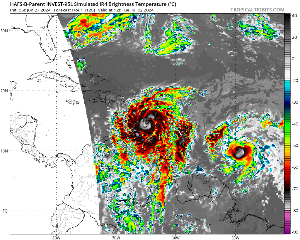
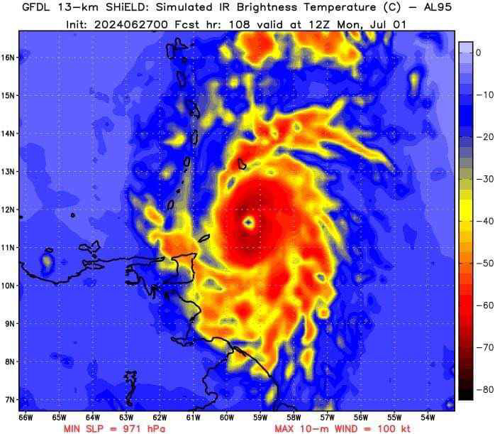
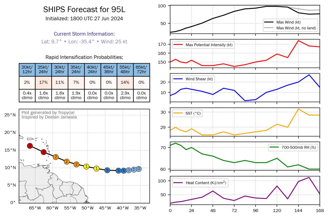
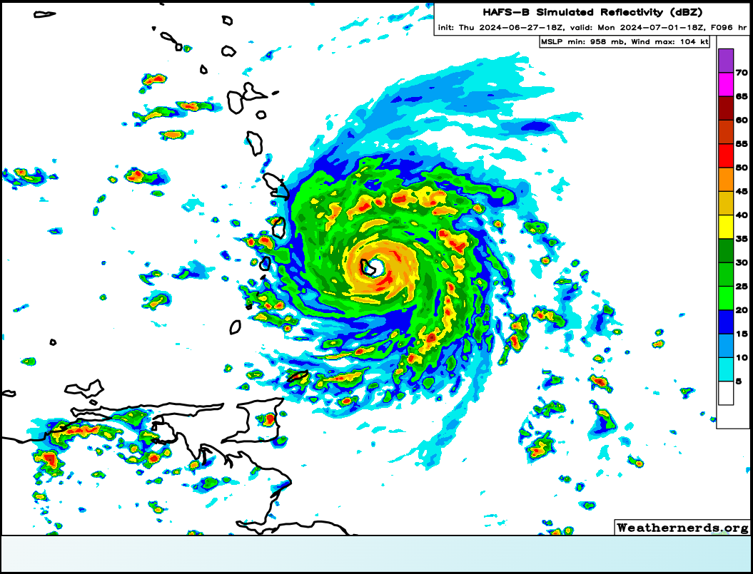
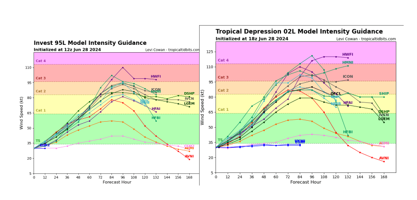
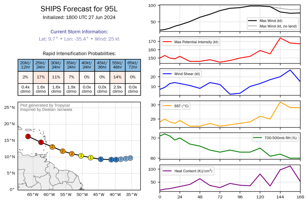
I asked AI to predict the peak intensity for 95L and it's not looking good, but I am too high inhib to post the full response here that states the peak intensity (they explicitly gave it). However, I can say this: Key Factors Influencing Intensity 850 mb Zonal Wind Anomaly: Indicates low-level shear due to anomalously westerly winds. This could initially challenge development but is less impactful for a well-developed system like 95L/Beryl. 200 mb Zonal Wind Anomaly: Shows anomalously easterly winds aloft, which favor lower shear and promote anticyclonic flow, aiding in outflow and reducing upper-level shear. Deep Layer Wind Shear: Predicted to be low along Beryl's path, which is conducive for strengthening, especially with the unusually warm sea surface temperatures (SSTs). Sea Surface Temperatures (SSTs): Warm SSTs provide ample energy for intensification. Given the temperatures are above average, this will support Beryl’s strengthening. 200 mb Wind Speed and Streamlines: Presence of an upper-level anticyclone (ULAC) providing favorable conditions for development. Model Guidance and Intensity Projections: GFDL SHiELD: Predicts significant strengthening with well-defined characteristics. SHIPS Forecast: Indicates rapid intensification potential with increasing maximum wind speed.
-
it's so jova for those in the path if this moggercane verifies. Hopefully the TUTT/trades/shear can mog 95L
-
Jova for barbadoscels
-
Implications for the Cruise: Until July 2: The cruise through the Yucatan and Cayman Islands should generally be safe, with the storm expected to remain to the south. July 3 (Jamaica): There is a significant possibility of the storm impacting Jamaica around this date. The models show a potential for the system to be at hurricane strength, which could bring strong winds and heavy rain. July 5 (Bahamas): The Bahamas could experience effects from the storm depending on its path and intensity. If the storm continues its projected track, it may affect this area, but there is more uncertainty compared to the Jamaica forecast.
-
Eastern Tropical Atlantic (AL95): A tropical wave located several hundred miles west-southwest of the Cabo Verde Islands continues to produce showers and thunderstorms. This activity is beginning to show signs of organization, and environmental conditions are forecast to remain conducive. Thus, further development of this system is anticipated, and a tropical depression or tropical storm is likely to form over the next couple of days while the system moves westward at 15 to 20 mph towards the Windward Islands. Interests in the Lesser Antilles should monitor the progress of this system. * Formation chance through 48 hours...high...70 percent. * Formation chance through 7 days...high...90 percent.
-
I don't know why they're only doing upgrades for the CONUS