EWR757
-
Posts
94 -
Joined
-
Last visited
Content Type
Profiles
Blogs
Forums
American Weather
Media Demo
Store
Gallery
Everything posted by EWR757
-
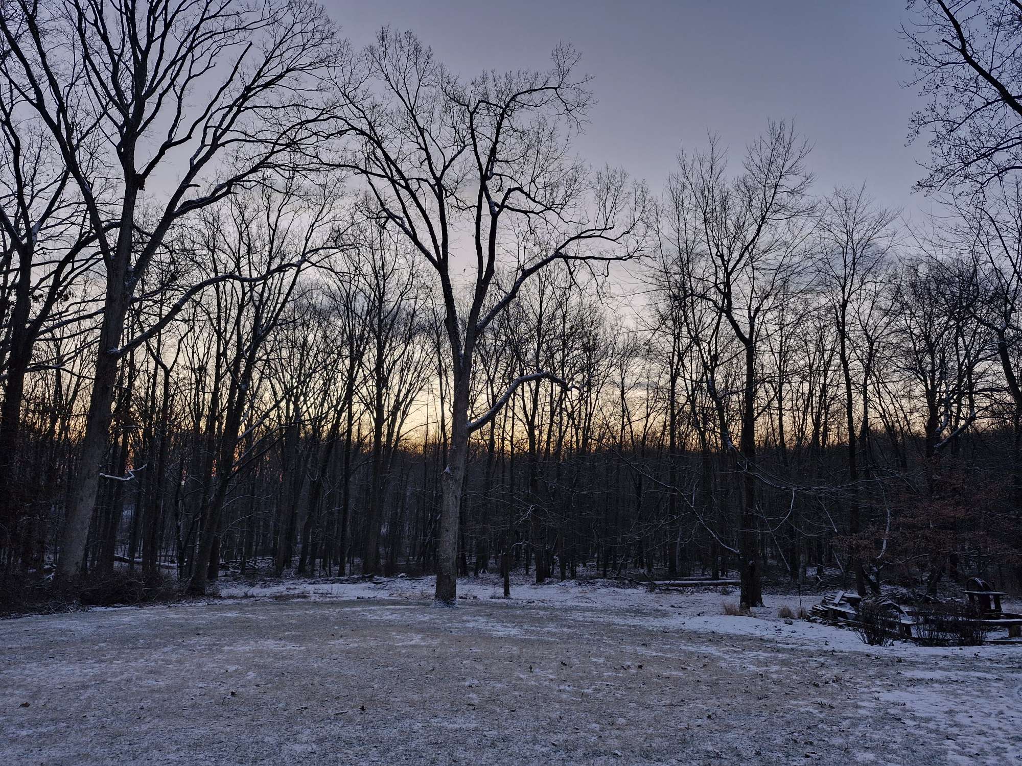
Beautiful photos of the ice on the Hudson River. It hasn't been that cold in a long time. Have you seen any ice breakers in the channel?
-
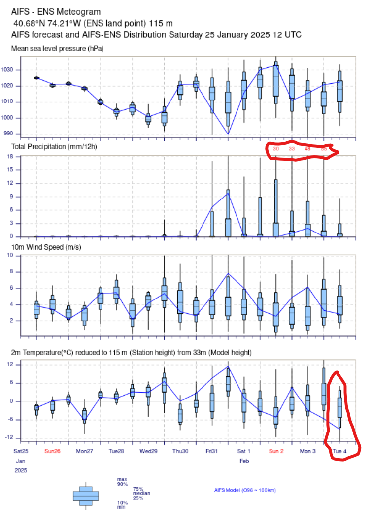
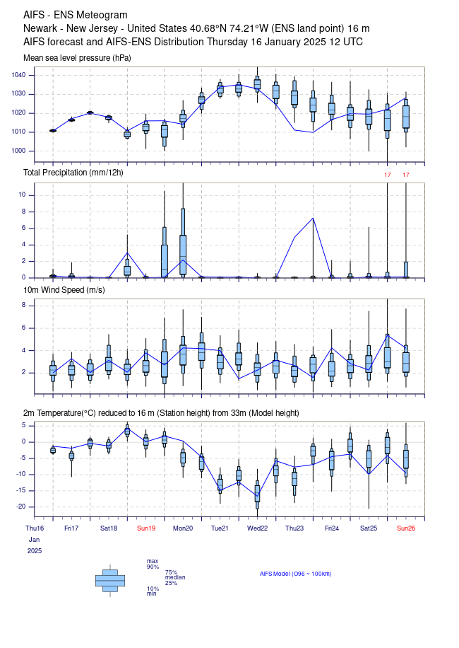
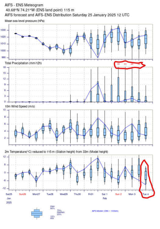
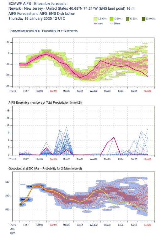
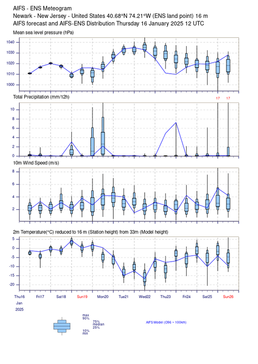
One thing I've noticed about the ECMWF AI (AIFS) is that the deterministic AI model is sometimes at the extreme of the ensemble output (for example, temperature highlighted in red towards the end of the forecast period). I don't remember this often occurring with the operational numerical model. Also, what are the small red numbers highlighted above the precipitation amount forecast in the last few days of the output? 15 degree minimum temperature difference today between me at 420 ft. vs. KSMQ at 105 ft. and 4 miles WNW this morning. A very steep inversion.
-
I would give my spleen for a dewpoint of 77 F right now. Florida isn't even an option these days. Yesterday Miami was in the 50s with fog. My skin is dry too, but where I suffer the most is my nose and sinuses. Give me 33 F, rain and dense fog any day of the week.
-
That would be great if it was. Hopefully the wind records can be verified. I watched on RTE News the highest ever sustained wind was also recorded in Ireland, at 135 km/h. I went to the Valentia Observatory a few years ago and there was not a human around. A nice automated setup though. https://valentiaisland.ie/history_culture/valentia-observatory/ Today: https://maps.app.goo.gl/MJ19XroqVhVzhJnk7
-
https://www.met.ie/latest-reports/observations Malin Head in Donegal failed as well. If you are ever in Ireland, it's fun visiting these automated stations. Hopefully the authority in Ireland can verify these historic measurements soon. https://www.rte.ie/
-
Nick is a great guy and he has had a wonderful career, especially considering our media market. And if you need a Designated Examiner at HPN you may want to make friends with him.
-
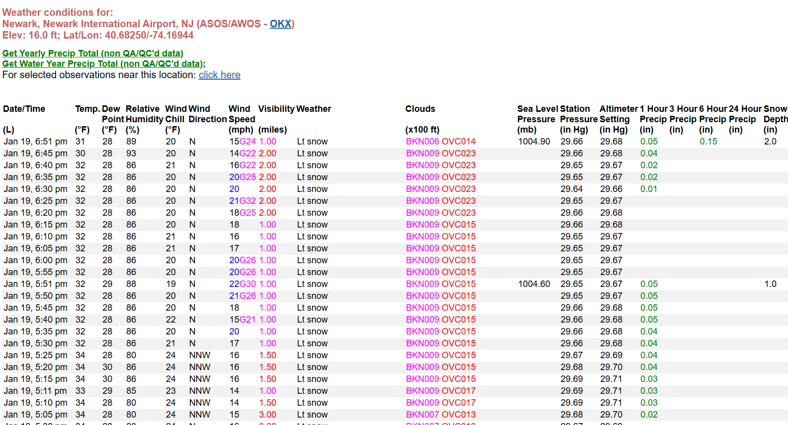
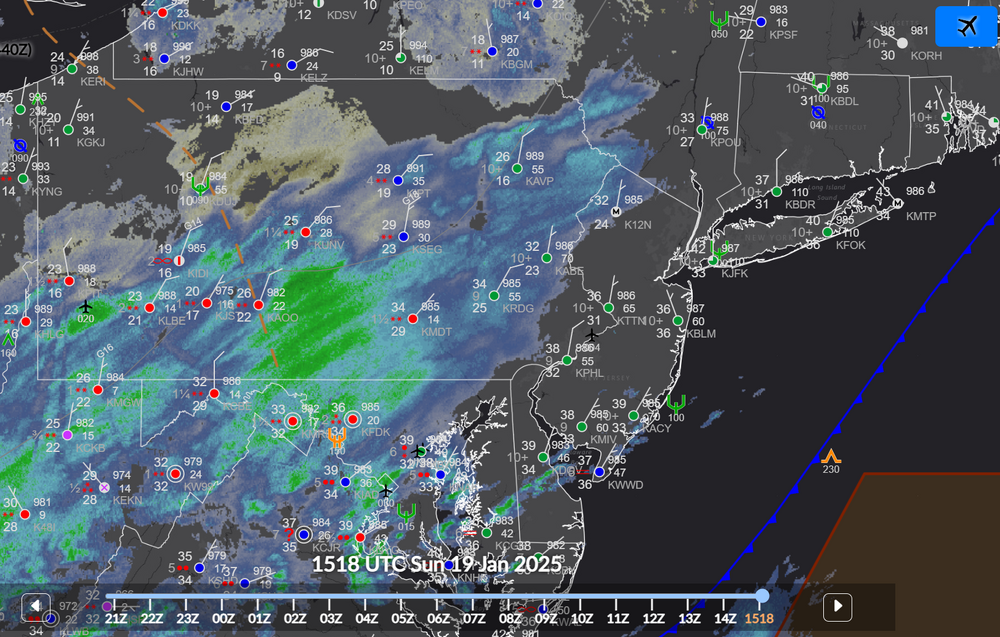
Regarding the storm on January 19th, the liquid equiv. precipitation amounts on Cocorahs across the area seem to fall into line with the consensus model predictions, but along the coast snowfall amounts tended to be less than forecast. I think this was likely due to the warm boundary layer and melting snow/mixed precip/rain during the initial part of the event.
-
 In retrospect, this ECMWF AIFS forecast made total sense. EWR went below freezing this evening just before 7 pm with 2 inches of new snow on the ground for the storm (so far). The AIFS (AI model) had the warm layer properly forecasted 60 hours in advance. The Google Graphcast had an even longer lead time, and the GFS MOS and 1000 hPa GFS charts eventually also showed the warm boundary layer near the coast. The AI models (including their temperature forecasts) are to be respected, in my opinion. The models did not fail in the situation. I'm glad the end of this storm has a good band of moderate to heavy snow more many people.
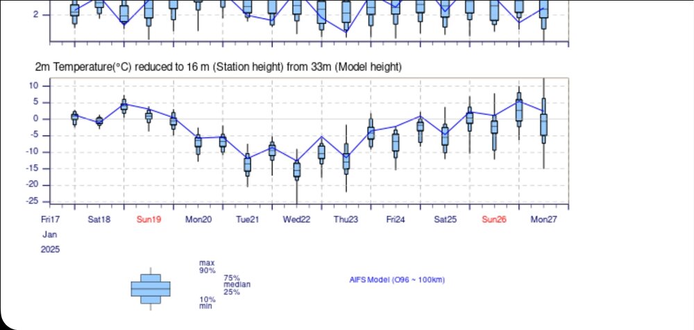
-
The band in eastern PA is solid, 3/8 SM or less visibilities at MUI, LNS, MDT, MRB and RSP. That should provide some moderate to heavy snow for the NYC Metro area this evening before the snow comes to the end.
-
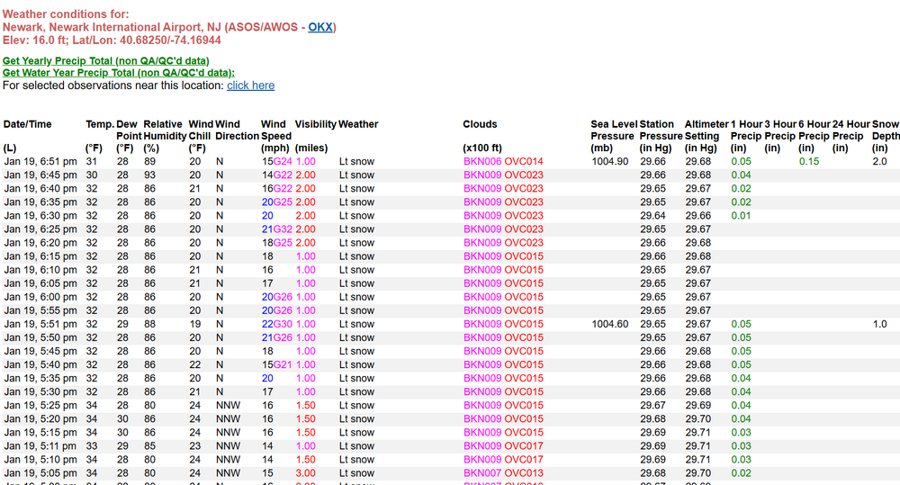
KEWR 191751Z 02008KT 10SM FEW021 SCT037 OVC055 04/M01 A2977 RMK AO2 RAB38E51 SLP080 P0000 60000 T00391011 10044 20028 58033 $
-
Higher than modeled?
-
-
Starting off the morning with my 2 rain gauges and snowboard ready for later today. 34 F with a broken layer of altocumulus. At ground level there is plenty of black ice. The 0.06" of rain yesterday melted the remaining snow on the ground. Hoping it works out for those of you along the coast that want snow. Compared to the 06Z GFS MOS, LGA and EWR are already above forecast temperatures and dewpoints.
-
Both PHI and OKX mention the possibility of rain at the start along the coast in their AFDs.
-
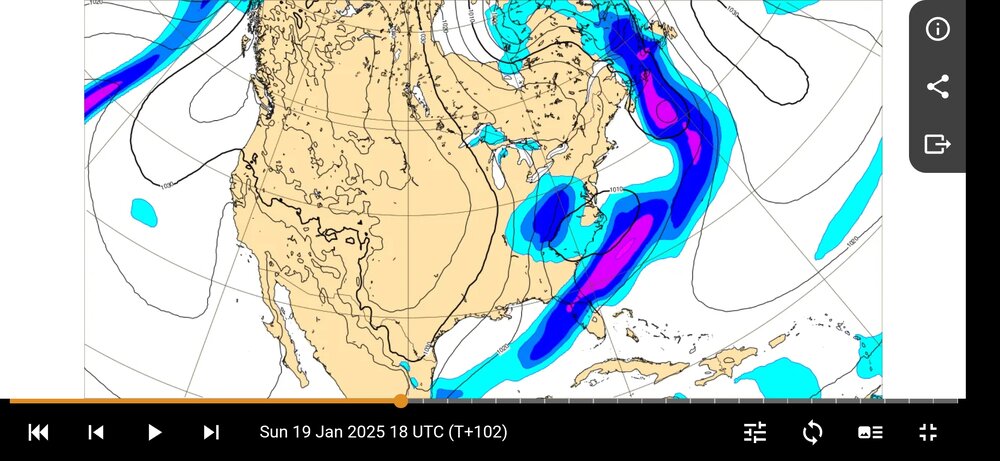
A lot of CMC trash talk. While the CMC shift was more significant for major population centers, I'll suggest the ECMWF was more meteorologically significant. The ECMWF AIFS AI did better, but it's likely the Google model did the best. There are still warm air issues along the coast and urban areas tomorrow for at least the first few hours of precipitation. NYC/EWR will be at best slush tomorrow afternoon, and could very well end up being melted snow or even a cold rain. Google Graphcast had the most correct position of the low since Jan 15:
-
SMQ is a good nocturnal radiational cooling location, however those nights have been few and far between this month with the cloud cover and strong winds. Quite the difference between LGA & JFK. Why do you think that is?
-
The 06Z GFS MOS has a max temp on Sunday at EWR of 38 F. Ironically, the GFS MOS also has 8" or more of snow for EWR. But, those are different statistical correlates and we can't have it both ways. This is an elevation / N & W storm. There will be no cold air along the coast. All hail to king CMC/GEM.
-
There ain't no way it will be cold enough close to the coast for a lot of snow. For the record (and get this notarized), the 18Z SUN temperature at EWR will be 37 F or higher. The arctic air is going to take a long time to move southeast with developing cyclogenisis.
-
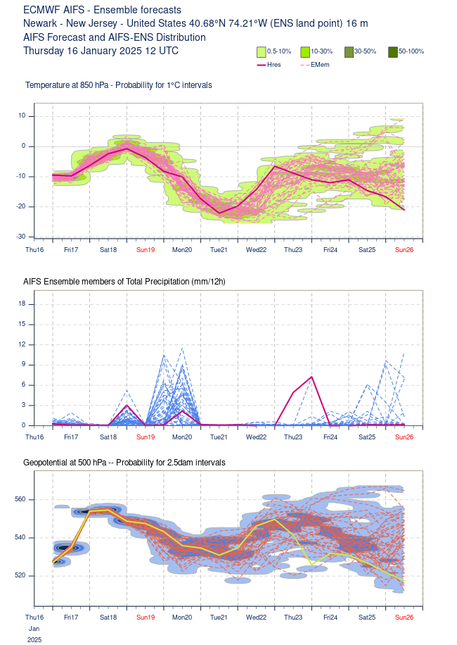
Tough one...I'll try (correct me if I'm wrong). "Regular" weather models rely on very complicated and time consuming math and physics to setup an initial state of the atmopshere at each grid point, then compute using physical laws the future state of the atmosphere. "AI/ML/DL" weather models use the initial state of the atmosphere determined by the above model (I think in all cases the ECMWF dataset) but then instead of using physical laws to determine the state of the atmosphere, similar patterns are found from previous data, and "experiences" of the AI. Think "analogs", but it is more complicated than that...perhaps "statistical physics" is a better analogy. The AI model can be run in a matter of minutes on a desktop, whereas the "regular" models need supercomputers and take a long time to run. The AI model grid spacing is currently very large...100 km or more, so they don't have the detail the "regular" models have, especially in the short-term. However, in the medium and long-range they seem very promising. In the past and today, meteorologists know which models behave well and which behave poorly, which models are initialized better than others, etc. They could perform a scientific analysis based on their understanding of how the model works and their meteorological expertise. With AI, that is a lot harder if not impossible (I think). https://deepmind.google/discover/blog/graphcast-ai-model-for-faster-and-more-accurate-global-weather-forecasting/ https://www.nature.com/articles/s41586-024-07744-y
-
As an example, the 12Z AIFS has EWR above freezing boundary layer until about 00Z on Monday. The GFS is similar.

-
The 12Z GFS has ~6" of snow for me in Somerset County, NJ beginning Sunday afternoon, about 0.49" water equiv. The cold air advection begins Saturday evening and as of Sunday morning and beyond the atmosphere is below 0 C. I think elevation may play a significant role with precipitation type and accumulation, the GFS just 25 miles east at KEWR is above freezing in the lowest levels most of the event.
-
.02" liquid / 0.3" snow in the last 24 hours. A quiet morning here with a low of 21 degrees, but colder downhill.
-
The warm air at the beginning of the event should receive the attention it deserves, even inland.
-
Yes. For example, these meteograms are from the 12Z Thursday run.
-
Very light snow here in Bridgewater, NJ most of the afternoon. The sun (now stars) have been visible throughout, less than 0.1". The HRRR output I saw before the snow began seemed to "miss" this event east of the Delaware River.