PhiEaglesfan712
-
Posts
1,718 -
Joined
-
Last visited
Content Type
Profiles
Blogs
Forums
American Weather
Media Demo
Store
Gallery
Everything posted by PhiEaglesfan712
-
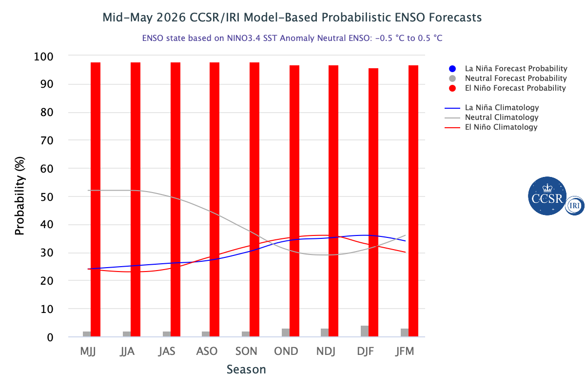
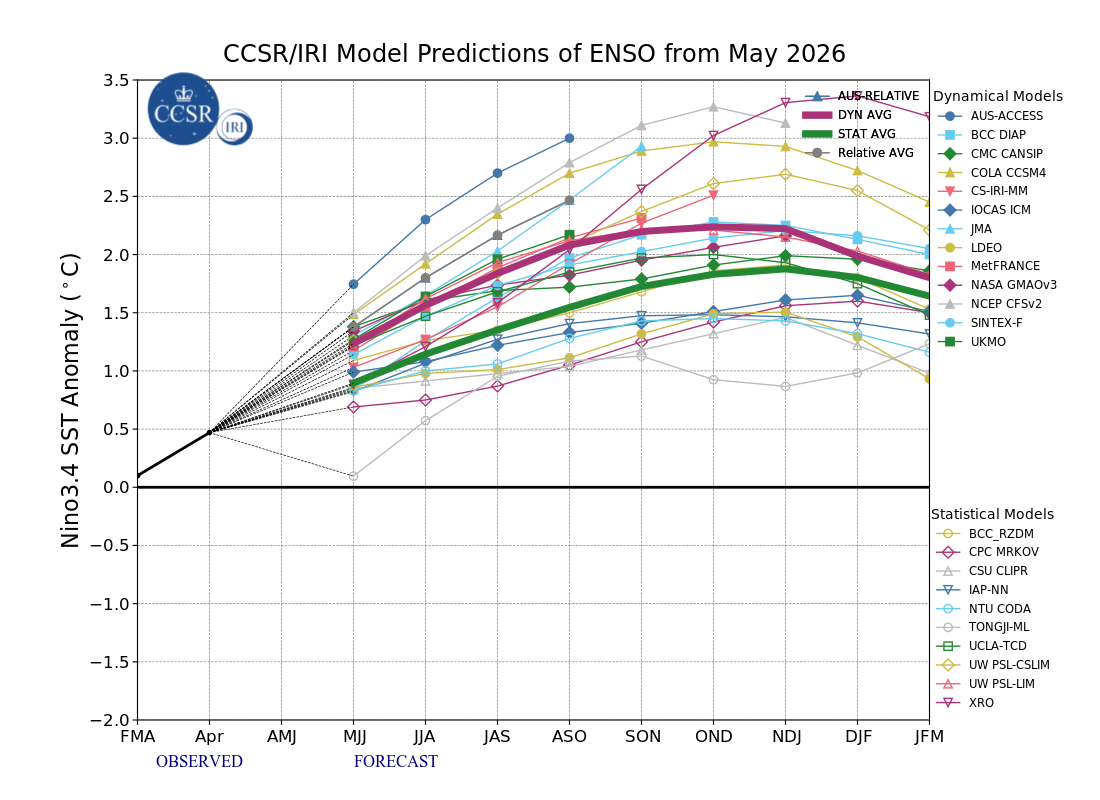
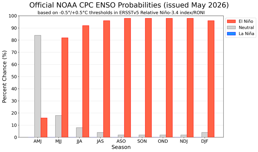
2026-2027 Super El Nino
PhiEaglesfan712 replied to Stormchaserchuck1's topic in Weather Forecasting and Discussion
-
Yeah, 1976 was the year when the highest temp was hit in April, during the Easter heatwave, for many spots in New England, and as far south as Philly. Things turned cold very early that season, with October 1976-January 1977 being the coldest October-January on record. (The spring that followed was one of the warmest on record, despite a snow event on May 9-10.)
-
2026-2027 Super El Nino
PhiEaglesfan712 replied to Stormchaserchuck1's topic in Weather Forecasting and Discussion
Oddly enough, 1991 was a pre-nino May (although there would be the major volcano the following month that made sure the nino event behaved weirdly). -
E PA/NJ/DE Spring 2026 Obs/Discussion
PhiEaglesfan712 replied to PhiEaglesfan712's topic in Philadelphia Region
You'll be back to mid-50s weather by Saturday. It's been that type of spring. -
2026-2027 Super El Nino
PhiEaglesfan712 replied to Stormchaserchuck1's topic in Weather Forecasting and Discussion
09-10 showed that we can get a good winter out of a strong modoki el nino. We just need a good blocking pattern. -
I expected the temperature swings to be done by now. I haven't seen a spring as bipolar as this one (I wonder if it's due to there being a really cold winter and the ocean temps are cold), and I'm starting to worry it will bleed into summer. We've had 80 degree days followed by 30 degree ones, 90 degree days followed by 40 degree ones, and now 95 degree days followed by 50 degree ones.
-
I hope this isn't a preview of summer. I'm just tired of these wild temperature swings. I'd much rather have it be one consistent temperature, whether it be the 90s, 80s, or heck, even 70s. But I can't do it if we're going to have runs in the 100s this summer, only to be followed by temps in the 50s soon thereafter.
-
2026-2027 Super El Nino
PhiEaglesfan712 replied to Stormchaserchuck1's topic in Weather Forecasting and Discussion
Yeah, that 2018-20 period was a disjointed at best. We didn't really have a definitive ENSO or PDO state during those years (the PDO was near neutral for the greater part of almost 4 years after the mid-2010s el nino dissipated), until we got to 2020-21, which was a solid la nina and -PDO. -
I know spring is prone to temperature swings, but I don't think there has ever been a more bipolar spring than this one. I hope this doesn't continue into the summer. Imagine it being 100+ degrees one day in July, and then only in the 50s at the same time the next day. I can't do that!
-
2026-2027 Super El Nino
PhiEaglesfan712 replied to Stormchaserchuck1's topic in Weather Forecasting and Discussion
-
Fun fact: Providence's highest temperature ever recorded in April is higher than its highest temperature ever recorded in May. In fact, it took until last year (when it reached 100 on June 24) for Providence to record a June temperature that was higher than its April 1976 record high.
-
E PA/NJ/DE Spring 2026 Obs/Discussion
PhiEaglesfan712 replied to PhiEaglesfan712's topic in Philadelphia Region
Not only has a mid-May freeze happened before, there was one just three years ago: -
As long as it's not 50 degrees in the daytime soon thereafter, I'll be okay with this.
-
E PA/NJ/DE Spring 2026 Obs/Discussion
PhiEaglesfan712 replied to PhiEaglesfan712's topic in Philadelphia Region
This has to be the most bipolar spring ever, in terms of temperature. I've never seen so many temperature swings in my lifetime. We've seen it go from 30s to 80s and back, 40s to 90s and back, etc. I don't mind temps in the 70s, 60s, or even 50s, as long as it's consistent. I just don't like the 40-50 degree swings we've been getting this year. -
If we get a 90-degree day in May, this spring would be the first ever to get an 80 in March, and a 90 in both April and May, correct?
-
Oh what could have been if winter didn't disappear and March and April in 1977. It was already a big snow year as it was, but it could have been even bigger if March and April didn't absolutely torch. More recently, there was a snow on May 9, 2020 (as well as a freeze on May 18, 2023). Those events happened after very warm and low snow winters.
-
2026-2027 Super El Nino
PhiEaglesfan712 replied to Stormchaserchuck1's topic in Weather Forecasting and Discussion
1998-99 was the first year of a double-year strong la nina. 1997-98 was the super el nino year, and yes, that one was a record low snow year. 1982-83 was a classic backloaded el nino winter, with the blizzard in February and late freeze/snow event on April 19-20. -
Yeah, barring a major volcanic event happening really soon (like Pinatubo did in mid-June just before a robust el nino), I think most of us can agree that there will be another baseline temperature jump coming.
-
2009-10 is a perfect example that proves that a strong el nino winter can be cold and snowy.
-
The thing is, the warmer pre-strong/super el nino summers in the Eastern US (1991 and 2015) were preceded by borderline warm neutral/weak el nino winters. We did not have that this year, like in 1972, 1982, 1986, 1997, 2009, and 2023. All of those years had cooler summers.
-
2026-2027 Super El Nino
PhiEaglesfan712 replied to Stormchaserchuck1's topic in Weather Forecasting and Discussion
91-92 would have probably had a big global temperature jump if not for Pinatubo. It was the 3rd robust el nino in 10 years, and coming off the heels of a temperature jump from the 86-88 el nino. But my guess is that if Pinatubo never happens, 97-98 still has a temperature jump, but not as drastic. 97-98 not only had the super el nino, but the exiting of a cooling period from a major volcano to enhance its temperature jump. -
Forget the 1-8 formatting, we have a better chance if the NHL expands the playoffs, preferably to 24 teams (like in 2020), and seed 1-12.
-
2026-2027 Super El Nino
PhiEaglesfan712 replied to Stormchaserchuck1's topic in Weather Forecasting and Discussion
If that's the case, then I guess you're pretty much certain on a flip to +PDO. Probably going to mean an AN temperature winter, but I'd take my chances of this (both 1982 and 2015 had a major snowstorm), rather than a deep -PDO robust el nino like 1972 or 2023. -
2026-2027 Super El Nino
PhiEaglesfan712 replied to Stormchaserchuck1's topic in Weather Forecasting and Discussion
The PDO being in the slightly negative/neutral range gives me hope. The PDO was like that in 2009-10. It just comes down to blocking pattern. If we can get a blocking pattern like 09-10, then maybe, just maybe, we could get a great winter out of this. 09-10 I believe was also a strong +PMM winter, too: https://psl.noaa.gov/data/timeseries/month/data/pmm.data -
2026-2027 Super El Nino
PhiEaglesfan712 replied to Stormchaserchuck1's topic in Weather Forecasting and Discussion
April PDO -1.48 (actually lower than March's -1.43 PDO). This is a huge surprise, especially if we're heading towards a super el nino. 1972 (-1.70), 2009 (-2.23), and 2023 (-3.08) are the only strong/super el ninos that had a lower PDO in April. 1972 and 2023, of course, stayed negative, while 2009 went towards a neutral PDO.