

PhiEaglesfan712
-
Posts
1,719 -
Joined
-
Last visited
Content Type
Profiles
Blogs
Forums
American Weather
Media Demo
Store
Gallery
Everything posted by PhiEaglesfan712
-
2026-2027 Super El Nino
PhiEaglesfan712 replied to Stormchaserchuck1's topic in Weather Forecasting and Discussion
The 3 el ninos in the 82-92 period were all robust, though. The 88-89 la nina happened after the 2nd event. That's the only time really that robust el ninos were so close to each other. It will be interesting to see, after this el nino event, if the same pattern follows, and get such a strong la nina. -
2026-2027 Super El Nino
PhiEaglesfan712 replied to Stormchaserchuck1's topic in Weather Forecasting and Discussion
72-73 was followed by a strong la nina (part of a triple la nina), and preceded by a double la nina: 1970-71 - moderate la nina 1971-72 - weak la nina 1972-73 - super el nino 1973-74 - strong la nina 1974-75 - weak la nina 1975-76 - strong la nina -
2026-2027 Super El Nino
PhiEaglesfan712 replied to Stormchaserchuck1's topic in Weather Forecasting and Discussion
72-73 is the only super el nino that followed a double la nina. From the strong group, you have 09-10 following a double la nina, with 57-58 and 23-24 following a triple la nina. Of course, 72-73, 86-88, 97-98, and 09-10 were all followed by strong la ninas, with 72-73 and 97-98 followed by a triple la nina, and 09-10 followed by a double la nina. Even 15-16 was followed up by a double dip la nina, although both years were weak la ninas. -
2026-2027 Super El Nino
PhiEaglesfan712 replied to Stormchaserchuck1's topic in Weather Forecasting and Discussion
Yeah, almost all el ninos do that, with the obvious exception of 1986-88 (which peaked in between seasons, in the summer of 87). However, the earlier the peak/fall off, the more likely for a strong la nina the following year. Just look at 1973, and the aforementioned 1988, for example. Those years got very close to, or even breached, -2.0C. -
2026-2027 Super El Nino
PhiEaglesfan712 replied to Stormchaserchuck1's topic in Weather Forecasting and Discussion
We're definitely overdue a strong la nina. The last time we had 2 robust el ninos back-to-back was the series that began with the 82-83 super el nino (when we had 3 in a decade). After the 2nd el nino (86-88) followed a strong la nina (88-89). I have a feeling that we're going to have a strong la nina after this strong/super el nino event. 82-83: super el nino => 23-24: strong el nino 83-86: -ENSO event => 24-26: -ENSO event 86-88: strong el nino => 26-27 (or 26-28): robust el nino 88-89: strong la nina => 27-28 (or 28-29): strong la nina??? -
2026-2027 Super El Nino
PhiEaglesfan712 replied to Stormchaserchuck1's topic in Weather Forecasting and Discussion
I saw this Early 2026-2027 Snowfall Insight on LinkedIn: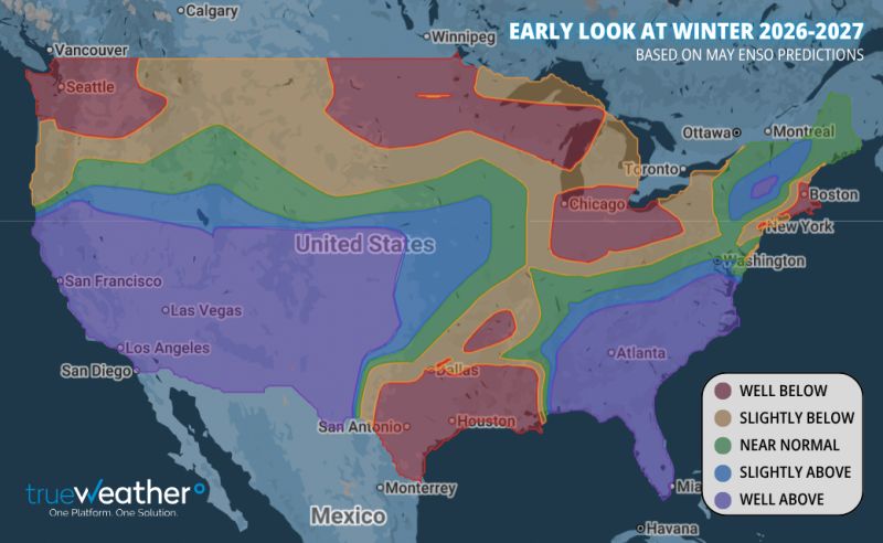
-
1991 is the only one of the high-end el nino events that really compares. There was a heat wave at the end of May, and that really set the tone for the entire summer. 2015, to a lesser extent, but we didn't have the warmth in June, but rather in the back half of the summer into September. Both of those years had a borderline warm neutral/weak el nino leading up to it. We didn't have that in the lead up to this year. I expected this summer to be a textbook pre-nino summer that was cooler than recent summers, like 1972, 1982, 1986, 1997, 2009, and 2023. If we can't get even get a cool summer in this setting, I wonder what it will take to get one. (Short of a major volcanic eruption, like Pinatubo in 1991, which caused 1992 to be notably colder, I probably don't see it happening any time soon, if not ever.)
-
Not really, there is something called seasonal lag, which is why the hottest days on most years are deep into July, sometimes in early August. Besides, the days have noticeably stopped getting longer, especially on the morning side. At night, it is still getting light later. By around June 13-14, most places in this area will have seen their max daylight (it might still be technically getting longer by a second or two, but that's junk change when you have 15 hours of daylight), and that will go on until about June 26-27.
-
2026-2027 Super El Nino
PhiEaglesfan712 replied to Stormchaserchuck1's topic in Weather Forecasting and Discussion
May 2026 PDO: -1.76 MAM 2026 ONI: +0.5 MAM 2026 RONI: -0.1 Eric Webb finally updated his page: https://www.webberweather.com/ensemble-oceanic-nino-index.html He considers 2025-26 to be a weak la nina, and 2024-25 to be a 'maybe weak la nina' (borderline cold neutral/weak la nina), and lowered the strength of 2011-12, 2021-22, and 2022-23 to weak la nina (had previously been considered moderate), and upgraded 1892-93 to a strong la nina. -
2026-2027 Super El Nino
PhiEaglesfan712 replied to Stormchaserchuck1's topic in Weather Forecasting and Discussion
Global temperatures will jump, unless we get an eruption of Mt. Rainier (and really soon). Remember, Pinatubo erupted in mid-June of a developing strong el nino. Prevented a temperature jump from happening in 1992, and in fact temporarily caused a decrease in global temperatures. Also, led to one of the coldest summers on record CONUS in 1992, as well as contributed to the great winters of 1992-93, 1993-94, and 1995-96 in the Eastern US. -
Idalia (in 2023) should have been retired as well. I guess there must be a shortage of I names that they need to keep them in there unless there is a truly historic storm.
-
E PA/NJ/DE Spring 2026 Obs/Discussion
PhiEaglesfan712 replied to PhiEaglesfan712's topic in Philadelphia Region
May average temperature finishes at 65.6 at PHL, which is 1.3 degrees above the 1991-2020 average (1.7 degrees above the 1981-2010 average). Meterological spring average temperature finishes at 57.8 at PHL, which is tied for the 3rd warmest spring on record (with 1921, and behind only 2010 and 2012). -
2026-2027 Super El Nino
PhiEaglesfan712 replied to Stormchaserchuck1's topic in Weather Forecasting and Discussion
What about a one-month relaxation like 1994-95 (which was a -PDO el nino)? November 1994-January 1995 were really warm and snowless, but there was a cold and snowy window in February 1995, before the warm and snowless weather returned in March. 94-95 ended up very warm and below average snowfall, but at least we got a respectable winter month out of it. -
The bipolar weather just doesn't seem to stop this year. It seems like this summer is going to have several 100-degree days, and several 55-degree days as well.
-
2026-2027 Super El Nino
PhiEaglesfan712 replied to Stormchaserchuck1's topic in Weather Forecasting and Discussion
New York Post posted an article about Mt. Rainier possibly erupting: https://nypost.com/2026/05/29/science/most-dangerous-us-volcano-mt-rainier-could-devastate-60000-residents/ This is probably the only thing that can prevent another temperature jump from this upcoming el nino. Remember that Pinatubo erupted in mid-June 1991, ahead of a robust el nino. -
2026-2027 Super El Nino
PhiEaglesfan712 replied to Stormchaserchuck1's topic in Weather Forecasting and Discussion
If you told me this upcoming el nino is going to be a modoki, I'll gladly take my chances with it. -
2026-2027 Super El Nino
PhiEaglesfan712 replied to Stormchaserchuck1's topic in Weather Forecasting and Discussion
Plus, a similar strength el nino in 09-10, which produced a very cold (and in the mid-Atlantic, very snowy winter) happened in between. In hindsight, though, we probably should have seen that 25-26 was going to be a cold and snowy winter in the East, and warm in the West. 25-26 was the 2nd year without a defined ENSO state. In recent times, 2nd years without a defined ENSO state (93-94 and 13-14) were cold and snowy in the East, and warm in the West. -
The easiest compromise is to meet halfway, and make it permanently 30 minutes ahead of standard time.
-
With Memorial Day in the rearview mirror, it's now time to start the summer thread. We have a developing strong/super el nino. Such summers are known for producing cooler than normal summers in the Eastern US. Such years include 1972, 1982, 1986, 1997, 2009, and 2023.
-
Can you expand these to 3 days (Saturday, Sunday, and Monday), so I can see the whole picture for the entire Memorial Day weekends? For example, 2021 at 72 and 0.00 rain looks misleading because you had highs in the 50s (probably record low maxes) and a lot of rain on Saturday and Sunday.
-
E PA/NJ/DE Spring 2026 Obs/Discussion
PhiEaglesfan712 replied to PhiEaglesfan712's topic in Philadelphia Region
You must either have the shortest memory ever or you are purposely trying to manipulate things. I love how you just disappear during a heatwave, when the weather doesn't support your agenda. I didn't see you post in early March when it was in the 80s, or in mid-April when it was in the 90s either. Anyways, you only have to go back 5 years to find a colder Memorial Day weekend (I remember this because I got my first COVID shot that Saturday, and man that was a very miserable weekend): 2021-05-29 54 48 51.0 -17.1 14 0 0.66 0.0 0 2021-05-30 53 47 50.0 -18.4 15 0 0.29 0.0 0 -
Yeah, the fact that no monthly record low was set in the post-Pinatubo years (1992-1996) makes me believe it's never going to happen again. Global temperatures have jumped so much in the last 30 years.
-
Big Temperature swings this spring 2026-03-10 83 40 61.5 19.9 3 0 0.00 0.0 0 2026-03-11 83 52 67.5 25.6 0 3 0.02 0.0 0 2026-03-12 69 35 52.0 9.8 13 0 0.16 T 0 2026-03-13 49 31 40.0 -2.5 25 0 0.00 0.0 0 2026-03-31 81 62 71.5 22.9 0 7 0.00 0.0 0 2026-04-01 84 58 71.0 22.0 0 6 0.47 0.0 0 2026-04-02 58 43 50.5 1.1 14 0 0.13 0.0 0 2026-04-03 71 44 57.5 7.7 7 0 T 0.0 0 2026-04-04 84 48 66.0 15.9 0 1 0.00 0.0 0 2026-04-05 73 48 60.5 10.0 4 0 0.41 0.0 0 2026-04-06 59 43 51.0 0.1 14 0 T 0.0 0 2026-04-07 56 38 47.0 -4.3 18 0 T 0.0 0 2026-04-08 55 31 43.0 -8.7 22 0 0.00 0.0 0 2026-04-15 91 62 76.5 22.1 0 12 T 0.0 0 2026-04-16 91 65 78.0 23.2 0 13 0.00 0.0 0 2026-04-17 83 67 75.0 19.8 0 10 0.00 0.0 0 2026-04-18 78 53 65.5 10.0 0 1 0.00 0.0 0 2026-04-19 57 44 50.5 -5.4 14 0 0.01 0.0 0 2026-04-20 55 40 47.5 -8.8 17 0 T 0.0 0 2026-04-21 58 34 46.0 -10.6 19 0 0.00 0.0 0 2026-05-18 96 65 80.5 15.7 0 16 0.00 0.0 0 2026-05-19 98 71 84.5 19.4 0 20 0.04 0.0 0 2026-05-20 95 69 82.0 16.6 0 17 0.21 0.0 0 Saturday's high projected to be only in the 50s.
-
2026-2027 Super El Nino
PhiEaglesfan712 replied to Stormchaserchuck1's topic in Weather Forecasting and Discussion
1982 wasn't W based. That one topped out at +4.6 on Nino 1+2, which is even higher than 1997 (4.1). If anything, 1982 should be E based. 82-83 peaks Nino 1+2: 4.6 Nino 3: 2.9 Nino 3.4: 2.9 Nino 4: 1.3 97-98 peaks Nino 1+2: 4.1 Nino 3: 3.3 Nino 3.4: 2.2 Nino 4: 1.1 -
Is that an all-time record high for the station?


