

PhiEaglesfan712
-
Posts
311 -
Joined
-
Last visited
Content Type
Profiles
Blogs
Forums
American Weather
Media Demo
Store
Gallery
Posts posted by PhiEaglesfan712
-
-
On 9/5/2024 at 8:38 AM, 40/70 Benchmark said:
1971-1972 could be a decent analog...I just don't like how La Nina died so early on in the winter season, which is probably at least partly why February was such a good month....maybe be an okay analog for the first half.
Isn't it common for last year la ninas to die early on? It happened in 1950-51, 1956-57, and to an extent 2022-23. None of those years were good snow years at PHL (all finished below 8 in of snow). Even with the snowy February, 1971-72 finished with just over 12 in of snow at PHL.


-
8 hours ago, snowman19 said:
IMO the dry pattern we entered at the tail end of August is going to have staying power this fall. I’m expecting the next 3 months (SON) to be drier than normal as well as warmer than normal
I just have to hope for a mudstorm in late October, like 2007, or we're probably going to have a drought in the mid-Atlantic.
-
13 minutes ago, 40/70 Benchmark said:
I remember October 2007 was very warm before it flipped.
Yeah, we got a record warm October, then the mudstorm happened the last weekend of the month. If not for the mudstorm, we probably would have had a drought during the 2007-08 winter.
Of course, November and December were cooler than average. Then, January-April were above average, but nothing really out of the ordinary.
-
21 minutes ago, GaWx said:
Here in the SE, 1957-8 was a top notch winter with very cold in Jan/Feb. along with a pretty rare 1” of snow way down here (in mid-Feb)! Savannah actually had a very rare 3 wintry precip events in JF, two of which were traces. ATL had a major winter storm in Feb. A near perfect El Niño for the Deep South! Maybe again in 2025-6??
More likely 2026-27 or even 2027-28. El ninos don't form that quickly. Remember, they were hyping up an el nino in 2012-13, but it didn't form until 2014-15.
-
 1
1
-
 1
1
-
-
Imagine the cold and snow in the winter following this modoki el nino:

I don't think this will happen next summer (as CanSIPS is showing), but I think something like this could form a year or two down the road (in 2026-27 or 2027-28). We'd probably be in +PDO and -AMO. The blob in the North Pacific looks eerily similar to 2013-14 and 2014-15.
-
Of course, 1957-58 is one of those rare cases where everything came together oh so perfectly during a stronger el nino winter:


-
3 minutes ago, michsnowfreak said:
When I was younger, I always read my sisters Little House on the Prairie Book "The Long Winter". That book took place on the Dakota prairie during the winter of 1880-81. The next story in the series (idk remember the name) would have taken place during 1881-82. Although the focus of that book was not on the weather as The Long Winter was, there were some blurbs about how they were trying to get extra precautions in place (autumn 1881) because of the disasters the hard winter the year before caused, and instead the winter ended up being springlike and "open".
In fall 2011, when I was a student at Drexel, I read this book for one of my classes:
I remember somewhere in the book where they talk about the winter of 1957-58 being very snowy and cold.
-
1 minute ago, LVblizzard said:
My match next weekend is women’s tennis but I also get assigned to lots of men’s matches.
I'm a huge tennis fan. Tomorrow is a big sports day for me. Fritz-Tiafoe, then the Eagles play their opener.
-
16 minutes ago, snowman19 said:
If it’s correct then it’s a flat Aleutian ridge as opposed to a poleward one, which would support more of the status quo we’ve been seeing since 15-16. And @40/70 Benchmark my question is if the AMO is ABOUT to flip, can we use -AMO analogs for this winter? Or would the flip have to be complete (probably not till next summer, assuming that’s what indeed is happening) to see the long wave effects from it? I’m just reluctant to say it’s definitely flipping because of the 13-14 -AMO false alarm
Yeah, the AMO/PDO flip is going to look something like 2012-16. If something is underway, I think 2024-25 would be the 2012-13 stage. Next summer/fall is when the PDO would be starting to flip. The flip will be apparent by the summer of 2026. Crazy as it sounds, I think we could get the modoki el nino the CanSIPS was showing, but maybe for 2026-27, and that would be the lead up to the super el nino event in 2027-28. Only difference is that the PDO/AMO doesn't flip back like it did in 2016-17.
-
42 minutes ago, bluewave said:
Most Novembers since the 15-16 super El Niño have been cooler in the East. So there isn’t much we can draw from that specific forecast about the winter. Plus we don’t know yet whether we just revert to the recent November decadal mean or this year does something different. We’ll have better clues after October. It’s been the only month of the year which has gone against the much warmer pattern.

Actually, since 2012 (the uber warm 2015 skewed everything):

For what it's worth, all of these Decembers were warm:

Of course, January-March in those years were cold (not so much 2013, which was a bit cooler than average especially February and March, but 2014 and 2015 were historically cold):

FWIW, the warmer Novembers since 2012 (aside from 2015) were 2016, 2020, and 2022. All of those years were central-based la ninas.
-
6 hours ago, Albedoman said:
no hell yet but if we do not get 1-2" rains by the the third week in Sept, we will be in a drought watch if not a warning. I am pissed off because this is perfect grass seeding weather as far as temps go but with no rain, the yard bare spots will be hard to heal before the frost and freeze sets in. Got down to 43 last night at my house however not much dew on the grass which is not a good sign for relieving the drought conditions.
We just need a mudstorm like late October 2007.
-
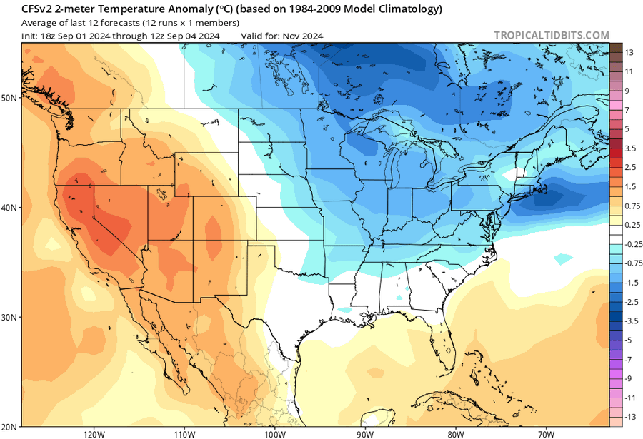
CFS showing a cool November for the midwest and most of the East (this bodes well for a good winter):
-
1
-
-
On 9/3/2024 at 10:18 AM, LVblizzard said:
I ref NCAA tennis and next Saturday is my first match of the season, I bet it rains just because that’s how it usually goes. Dry for weeks and suddenly rain when I need to be outside.
Is this men's tennis or women's tennis?
-
56 minutes ago, GaWx said:
Looking more closely, this new CANSIPS is forecasting Aug of 2025’s Nino 3.4 to be ~+1.0C unadjusted or ~.+0.5C adjusted downward for surrounding warmth. It has Nino 3.4 warmest and Nino 4 2nd warmest (only modestly cooler). So, it literally has a Modoki Nino forming by late summer. Of course fwiw due to very low probability of being accurate that far out. I can see it now. @George001titles next year’s main ENSO forecast thread “2025-6 Modoki El Nino”.


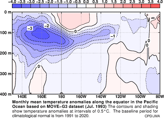
An el nino of +1.0C is almost certainly not going to happen in 2025-26. I think the only time we got an el nino of that strength with a cold subsurface the previous summer was 1994-95, when the subsurface in summer of 1993 looked like this:
-
 1
1
-
-
33 minutes ago, bluewave said:
The current cooler pattern in the East is due to the stronger MJO 5-6 region forcing than we have usually had in recent early Septembers. It’s one of the few times of the year when it’s actually a cool signal for us. Could also be combining with other factors previously discussed in this thread keeping the Atlantic unusually quiet. Since there continues to be sinking air and the AEW wave train is pushed further north than usual into the Sahara.


I remember September 2020 being on the cool end. Did we also have stronger MJO 5-6 region forcing that year?
-
10 minutes ago, GaWx said:
Fwiw, this CANSIPS map for Aug of 2025 implies a developing Modoki El Niño in time for ‘25-26. Opinions? @PhiEaglesfan712

I highly doubt an el nino is going to form in summer 2025, especially considering the subsurface was cold this summer. Plus, we are still in a deep cyclical -PDO pattern. An el nino is very unlikely to form under those conditions. Maybe if next summer the subsurface is warm and we have an ENSO neutral or dissipating la nina conditions in late winter/early spring 2026, I might entertain the thought of an el nino forming for 2026-27.
El ninos just do not pop up overnight. Their conditions are built under the surface over time. Sometimes, the conditions stay there for several years before they unleash their fury (just look at the years leading up to 1957-58 or the 3 years before 2015-16). You'll know when an el nino is coming, and sometimes years in advance. The conditions for an el nino aren't close to being there.
-
1
-
-
22 minutes ago, 40/70 Benchmark said:
Watch, NYC will get 10" this December and a trace the rest of the season.
It would probably have to be an east-based la nina like 2021-22, but the mismatch happening in December, rather than January. ACY would hit a snow jackpot in December in this case, but nothing for the rest of the season.
-
20 minutes ago, 40/70 Benchmark said:
My point being that I will take what is posted above over this knowing how useless the NAO has been in the face of an uttelry hostile Pacific.

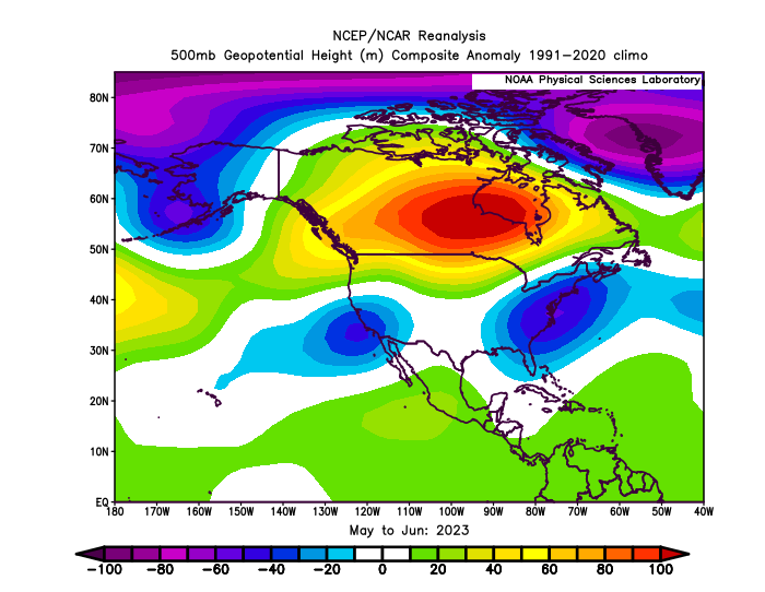
Can my winter look like this instead:
-
10 hours ago, JTA66 said:
110% agree. Same seems true for spring/summer. Get an official heatwave in April, we tend to have a relatively benign summer.
73F/DP 53F
The sample size of official heat waves in April is really small: 1976, 2002, and 2009. This certainly rings true for 1976 and 2009, but not 2002 (which was a very hot summer). Although each of those followed up with a very cold and snowy winter. Coincidentally enough, each of these years were a developing el nino.
-
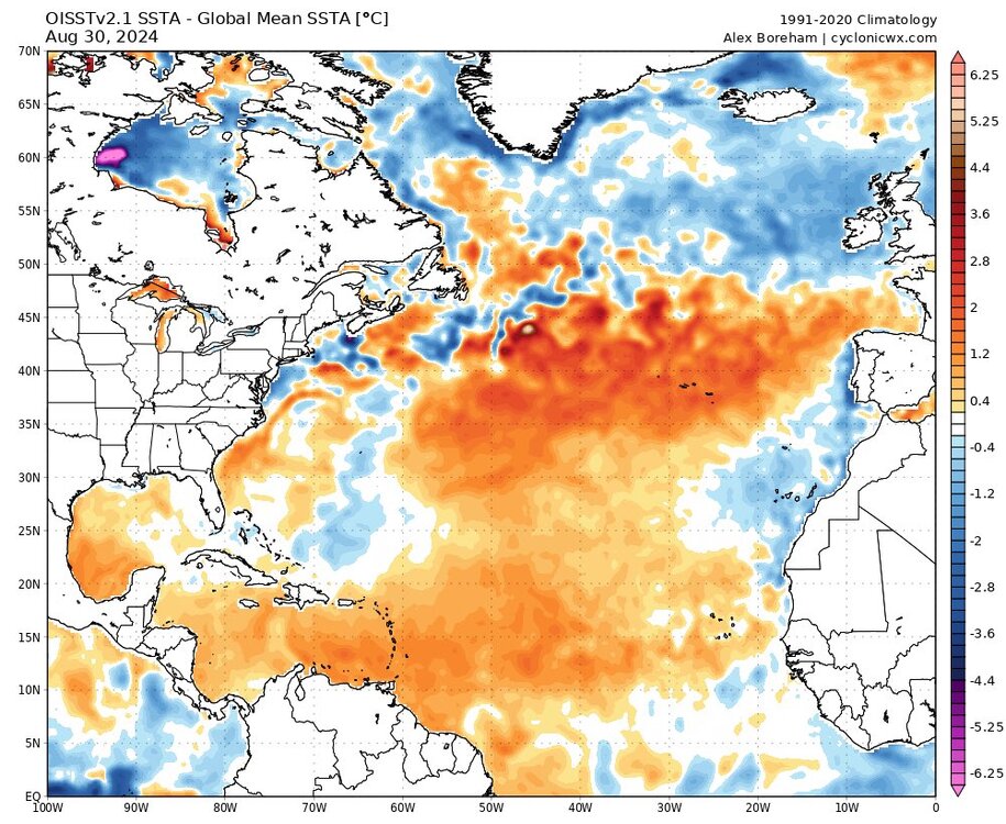
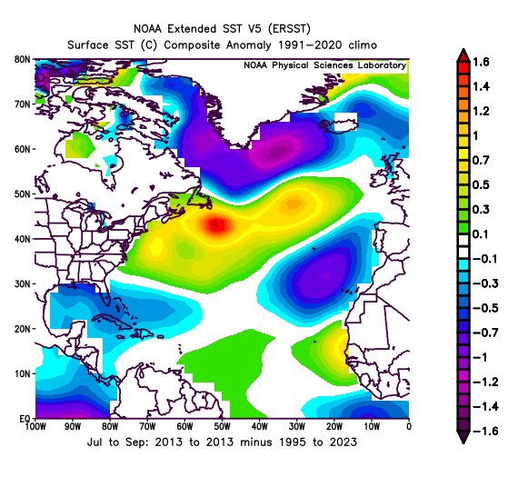
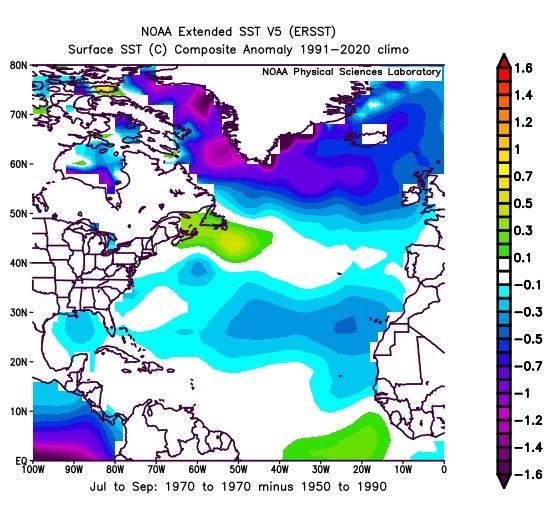
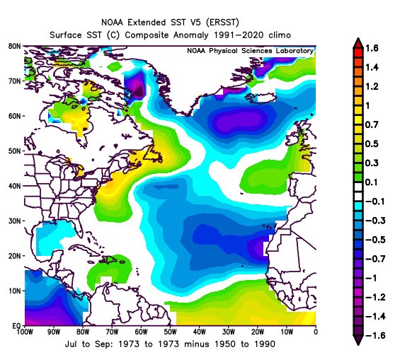
Another reason for the low number of named storms this year is the SSTa configuration. It mirrors quiet non-el Nino years like 1970, 1973, and 2013:
-
On 8/31/2024 at 10:39 AM, ChescoWx said:
As today is the last day of the final full summer month it appears like we will fail to see any of the Chester County stations touch the 100 degree mark for the for the 5th straight summer. Our last 100 degree day temperature was at Phoenixville (big surprise) on July 21, 2019. The next highest temperature that day was the 95.6 at West Bradford Twp. This is the longest stretch between a century reading since the 5 years between 1996 through 2000. The longest non-100 degree stretch was the 9 straight summers between 1902 through 1910.
I was thinking you were going to say a weird date outside of the season like October 2, 2019.
-
1
-
-
At this point, I bet we don't even reach the 140 ACE of 2016.
-
1 hour ago, bluewave said:
It’s the first time in known history that a El Niño summer ahead of a winter ONI of +2.0 or greater had 7 named storms and 2 category 4 hurricanes develop between August 20th and 31st to be followed by a developing La Niña the next summer with no new storms during this period.
2023
New developments between 8-20 and 8-31
TS Gert
TS Emily
Cat 4 Franklin
TS Harold
Cat 4 Idalia
TS Jose
TS Katina
2024
No new developments
I'm still salty about Idalia not getting retired. Lesser storms in the past have gotten retired. I guess the WMO changed the criteria and made it harder for storms to be retired. If Idalia didn't get retired, I highly doubt Debbie or Ernesto will. I think only really big storms, like Beryl, will be retired going forward.
-
3 hours ago, snowman19 said:
I also wonder how much of a factor the warm tropical tropopause in the Atlantic (AGW related) is playing in this…
-
1
-


E PA/NJ/DE Fall 2024 Obs/Discussion
in Philadelphia Region
Posted
Yeah, most of this fall is going to be dry, just as in my analog years of 1998 and 2007:
We just have to hope for a mudstorm in late October like 2007. Otherwise, we'll have our first drought in a really long time.