PhiEaglesfan712
-
Posts
1,718 -
Joined
-
Last visited
Content Type
Profiles
Blogs
Forums
American Weather
Media Demo
Store
Gallery
Everything posted by PhiEaglesfan712
-
E PA/NJ/DE Spring 2026 Obs/Discussion
PhiEaglesfan712 replied to PhiEaglesfan712's topic in Philadelphia Region
Nope, nothing alike. The high temperature for the entire month of March 1958 was 54. We're at 72 on the 2 pm EDT observation. There isn't going to be a historic snowstorm around the vernal equinox. -
A wild ride here in temperatures. Still very warm: 08 07:56 Vrbl 7 10.00 Mostly Cloudy FEW015 SCT042 BKN080 53.1 48.9 54 43 86% 29.64 1003.4 08 06:56 SW 8 G 17 10.00 Overcast SCT015 BKN023 OVC060 54 51.1 90% 29.63 1003.2 08 05:56 Vrbl 3 10.00 Overcast OVC015 53.1 51.1 93% 29.63 1002.9 08 04:56 Vrbl 7 G 21 10.00 Overcast OVC017 53.1 50 89% 29.63 1002.9
-
E PA/NJ/DE Spring 2026 Obs/Discussion
PhiEaglesfan712 replied to PhiEaglesfan712's topic in Philadelphia Region
Vermont is more influenced by the mountains. But there has a been a wild temperature swing the last 12-18 hours. From 58 to 40 and now back up to 54 at 7 am. Still well above average for this time of year at that latitude, and quite a contrast from negative temperatures following the late January snowstorm. -
If you're still holding out hope for a snow event, it's time to let go. The only people in the Eastern US that may see a wintry precipitation event going forward is in Northern New England, I'm not even sure they will get one.
-
Mid-50s in Vermont: 07 15:56 N 3 10.00 Fair CLR 54 43 67% 29.8 1009.1 07 14:56 Calm 10.00 Partly Cloudy SCT046 SCT095 55.9 44.1 65% 29.84 1010.2 07 13:56 N 3 10.00 Mostly Cloudy FEW055 BKN110 54 42.1 64% 29.88 1011.7 I'm here until Monday morning.
-
E PA/NJ/DE Spring 2026 Obs/Discussion
PhiEaglesfan712 replied to PhiEaglesfan712's topic in Philadelphia Region
If that's true, then it's warmer where I am in Vermont. I'm seeing mid-50s: 07 15:56 N 3 10.00 Fair CLR 54 43 67% 29.8 1009.1 07 14:56 Calm 10.00 Partly Cloudy SCT046 SCT095 55.9 44.1 65% 29.84 1010.2 07 13:56 N 3 10.00 Mostly Cloudy FEW055 BKN110 54 42.1 64% 29.88 1011.7 -
2025-2026 ENSO
PhiEaglesfan712 replied to 40/70 Benchmark's topic in Weather Forecasting and Discussion
-
11 years ago:
-
2025-2026 ENSO
PhiEaglesfan712 replied to 40/70 Benchmark's topic in Weather Forecasting and Discussion
February 2026 PDO is -1.01 This is the 74th straight month with a -PDO value. -
Not really, recently all of our cold/snowy winters seem to be consecutive: 2002-03, 2003-04, 2004-05; 2008-09, 2009-10, 2010-11; and 2013-14, 2014-15.
-
E PA/NJ/DE Spring 2026 Obs/Discussion
PhiEaglesfan712 replied to PhiEaglesfan712's topic in Philadelphia Region
Yeah, you need a lot of cold air in place. In the years when we had big snowstorms post-March 15 (1956, 1958, 2018, etc.) there were many days with below average temperatures (mostly in the 40s and even 30s, as well as at least one snow event) leading up to it: 1956-03-06 47 38 42.5 2.1 22 0 0.06 0.0 0 1956-03-07 51 38 44.5 3.8 20 0 0.13 0.0 0 1956-03-08 45 31 38.0 -3.0 27 0 0.50 T 0 1956-03-09 49 30 39.5 -1.8 25 0 0.00 0.0 0 1956-03-10 56 34 45.0 3.4 20 0 0.00 0.0 0 1956-03-11 59 40 49.5 7.6 15 0 0.06 0.0 0 1956-03-12 48 33 40.5 -1.7 24 0 0.09 T 0 1956-03-13 38 32 35.0 -7.5 30 0 0.09 0.7 T 1956-03-14 48 37 42.5 -0.3 22 0 1.56 0.0 0 1956-03-15 42 34 38.0 -5.1 27 0 0.00 0.0 0 1956-03-16 36 26 31.0 -12.4 34 0 0.73 1.3 T 1956-03-17 33 23 28.0 -15.7 37 0 T T 1 1956-03-18 30 25 27.5 -16.5 37 0 0.56 5.4 0 1956-03-19 30 23 26.5 -17.8 38 0 0.35 3.3 7 1958-03-01 46 39 42.5 3.4 22 0 0.00 0.0 0 1958-03-02 53 34 43.5 4.1 21 0 0.00 0.0 0 1958-03-03 49 38 43.5 3.9 21 0 0.17 0.0 0 1958-03-04 46 34 40.0 0.1 25 0 0.00 0.0 0 1958-03-05 47 34 40.5 0.3 24 0 0.00 0.0 0 1958-03-06 50 30 40.0 -0.4 25 0 0.00 0.0 0 1958-03-07 49 35 42.0 1.3 23 0 0.00 0.0 0 1958-03-08 46 31 38.5 -2.5 26 0 0.00 0.0 0 1958-03-09 40 28 34.0 -7.3 31 0 0.00 0.0 0 1958-03-10 53 34 43.5 1.9 21 0 T T 0 1958-03-11 54 31 42.5 0.6 22 0 0.00 0.0 0 1958-03-12 45 35 40.0 -2.2 25 0 0.00 0.0 0 1958-03-13 42 29 35.5 -7.0 29 0 0.39 1.4 1 1958-03-14 39 32 35.5 -7.3 29 0 0.66 0.6 2 1958-03-15 44 36 40.0 -3.1 25 0 0.00 0.0 T 1958-03-16 42 33 37.5 -5.9 27 0 0.00 0.0 0 1958-03-17 44 31 37.5 -6.2 27 0 0.00 0.0 0 1958-03-18 48 31 39.5 -4.5 25 0 T 0.0 0 1958-03-19 38 33 35.5 -8.8 29 0 0.81 1.4 0 1958-03-20 35 32 33.5 -11.2 31 0 1.76 9.6 4 2018-03-02 45 32 38.5 -0.9 26 0 0.86 1.5 0 2018-03-03 46 35 40.5 0.9 24 0 T T 1 2018-03-04 48 31 39.5 -0.4 25 0 0.00 0.0 0 2018-03-05 47 30 38.5 -1.7 26 0 0.00 0.0 0 2018-03-06 48 29 38.5 -1.9 26 0 0.23 0.1 0 2018-03-07 36 32 34.0 -6.7 31 0 1.28 6.0 T 2018-03-08 40 31 35.5 -5.5 29 0 0.00 0.0 4 2018-03-09 42 30 36.0 -5.3 29 0 0.00 0.0 3 2018-03-10 44 29 36.5 -5.1 28 0 0.00 0.0 2 2018-03-11 46 28 37.0 -4.9 28 0 0.00 0.0 1 2018-03-12 43 29 36.0 -6.2 29 0 0.06 T 0 2018-03-13 42 32 37.0 -5.5 28 0 0.03 T T 2018-03-14 41 29 35.0 -7.8 30 0 0.00 0.0 0 2018-03-15 46 32 39.0 -4.1 26 0 T 0.0 0 2018-03-16 42 31 36.5 -6.9 28 0 T T 0 2018-03-17 48 28 38.0 -5.7 27 0 0.00 0.0 0 2018-03-18 50 31 40.5 -3.5 24 0 0.00 0.0 0 2018-03-19 52 33 42.5 -1.8 22 0 0.00 0.0 0 2018-03-20 35 29 32.0 -12.7 33 0 0.40 0.9 0 2018-03-21 36 31 33.5 -11.5 31 0 1.06 6.7 1 We just don't have that coming up this year. We have temps forecasted in the 60s and 70s. I have a feeling anyone holding out hope for more snow is going to end up disappointed. -
E PA/NJ/DE Spring 2026 Obs/Discussion
PhiEaglesfan712 replied to PhiEaglesfan712's topic in Philadelphia Region
No, but anyone with common sense knows that there won't be 2 snow events post-March 10. That's only happened once ever (in 2018), and temperatures had cooled long before that. We won't get 2 snow events after this warmup. Besides, I haven't been wrong on everything this winter. I did say December would be below average temperaturewise, and I called this March warmup at least a month in advance. -
2025-2026 ENSO
PhiEaglesfan712 replied to 40/70 Benchmark's topic in Weather Forecasting and Discussion
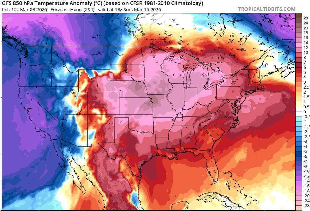
With the upcoming warmup, March is almost certainly going to end up above average in the Eastern 1/3 of the US. The only way we get a below average temperature departure is if we have something like this: 2011-03-23 40 32 36.0 -8.8 29 0 0.87 T 0 2011-03-24 44 30 37.0 -8.2 28 0 0.09 1.0 1 2011-03-25 42 28 35.0 -10.5 30 0 0.00 0.0 0 2011-03-26 40 26 33.0 -12.9 32 0 0.00 0.0 0 2011-03-27 45 28 36.5 -9.7 28 0 0.00 0.0 0 2011-03-28 45 26 35.5 -11.1 29 0 0.00 0.0 0 2011-03-29 49 31 40.0 -6.9 25 0 0.00 0.0 0 2011-03-30 53 36 44.5 -2.8 20 0 0.01 0.0 0 2011-03-31 43 37 40.0 -7.7 25 0 0.13 T 0 -
E PA/NJ/DE Spring 2026 Obs/Discussion
PhiEaglesfan712 replied to PhiEaglesfan712's topic in Philadelphia Region
We all know that isn't going to happen. The sun angle is too high and the ground/temps are too warm. Any precip that falls from now until October will be rain. -
2025-2026 ENSO
PhiEaglesfan712 replied to 40/70 Benchmark's topic in Weather Forecasting and Discussion
Cold is not returning any time soon: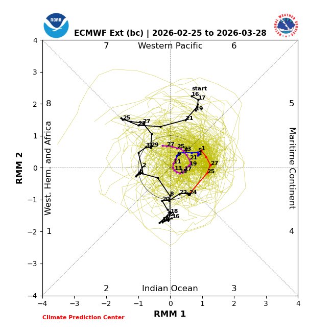
-
The difference is that in 2018, as well as in 2017, we had record warm Februarys. It shouldn't be surprising that things corrected, and we got snowy Marches those years. That's nothing like what we have this year. We had a cold and snowy February (and winter overall), like 2010. Things corrected in the opposite direction, and we got a warm March and the below average temperatures never came back (until the following winter). I feel like we closer to this scenario than 2017 and 2018.
-
Late February/Early March 2026 Mid-Long Range
PhiEaglesfan712 replied to WxUSAF's topic in Mid Atlantic
It was 2013 and 2014. -
I'm thinking more like 2010. 2012 came off a wall-to-wall warm and snowless winter. 2010 came off a more cold and snowy winter, but flipped warm once the calendar flipped to March, and never really looked back.
-
The colder global temperature sweet spot ended with the 1997-98 el nino. Temperatures jumped with that super el nino, and have never went back to the pre-1997 baseline. Pinatubo was most likely the reason for the colder global temperature sweet spot.
-
2025-2026 ENSO
PhiEaglesfan712 replied to 40/70 Benchmark's topic in Weather Forecasting and Discussion
Yeah, we should pin the 2026-27 el nino thread, and unpin the 2023-24 el nino. -
Outta gas and Outta Time: Early March Winter Storm finale
PhiEaglesfan712 replied to Ji's topic in Mid Atlantic
This really won't happen. The sun angle is too high and temps are a bit too warm for snow. If anything happens, it will probably be rain. -
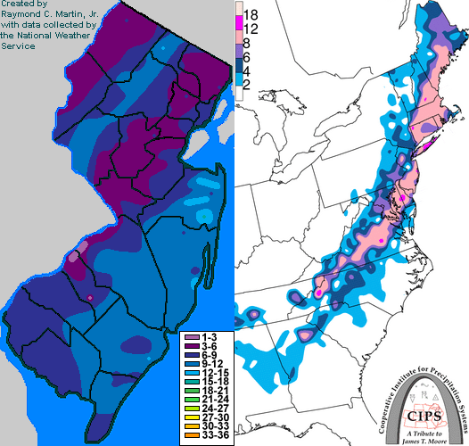
17 years ago, the Nor'easter that kicked off the great 7-9 year stretch of storms:
-
For this year, it's finished. The sun angle is going to prevent us from getting arctic cold. As for the next east coast snowstorm pattern, your guess is as good as mine. I can guarantee you, though, that there probably won't be one until at least November.
-
If true, that lawn is a deciduous forest by now. 1998 was 28 years ago.
-
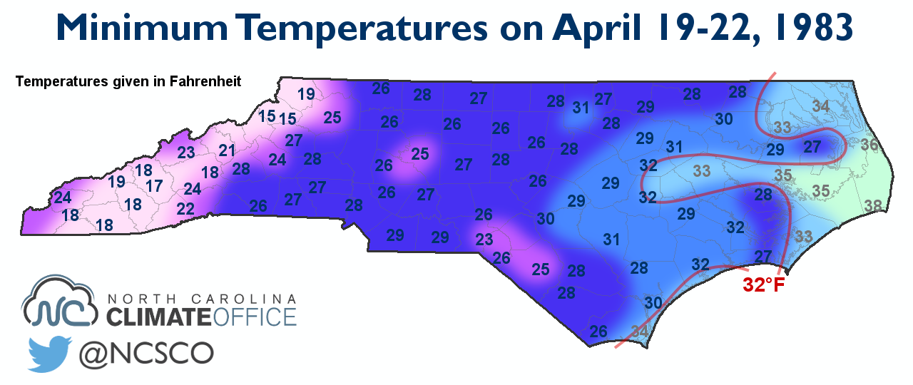
April 1983 takes the cake when it comes to hard freezes: It snowed in places like Philly and NYC during the 19th and 20th.