

smokeybandit
-
Posts
4,016 -
Joined
-
Last visited
About smokeybandit

Recent Profile Visitors
5,330 profile views


-
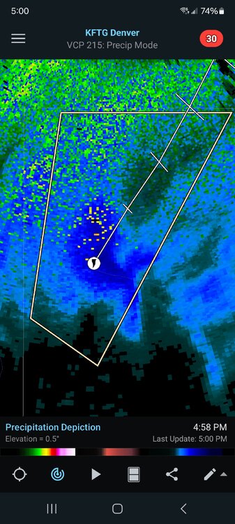
Pretty nice hail storm today, mostly pea sized, a few in the half inch range. Radar indicated tornado right down the road, but I don't think anything came of it from what my mostly untrained eyes saw
-
75" for the season, but if it wasn't for that November storm, it'd be a well below average year.
-
Got maybe 1" out of the 4-8" forecast. OK onto spring for real now
-
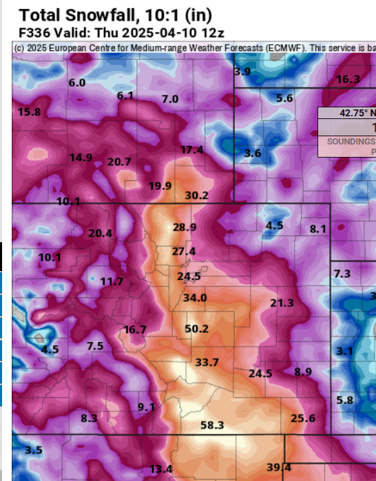
0z models are drastically cutting totals. Looks like yet another NWS bust.
-
Hopefully this last winter blast over performs after the last one whimpered away.
-
Yes, that cell that threaded the Elizabeth/Kiowa needle. That's by far the most thunder I've ever heard with snow. I ended up with nearly 2" from the afternoon stuff.
-
This is one you don't see every day
-
Only a trace accumulation today, but, just had some thundersnow which is always fun.
-
Just goes to show how far away the models are from anything out more than a couple days. That big snowstorm, still showing big numbers even last weekend, looks like just some nuisance snow showers.
-
I had the temps for snow, just ran out of moisture. Only a coating once it changed over. This coming weekend is still looking interesting.
-
I'm all for a massive storm to end the season. Got an inch of rain so far today, much needed. Might get some accumulating snow overnight.
-
18z GFS showing it, too. Probably a 1% chance to nail a blizzard 10 days out, but still interesting.
-
Well the Euro is drinking heavily today
-
If it ends now, I got over 70" again. But nearly half of that from that November storm.
-
Sure looks to be a disappointing end of winter for NE Colorado.

