

09-10 analogy
-
Posts
1,209 -
Joined
Content Type
Profiles
Blogs
Forums
American Weather
Media Demo
Store
Gallery
Everything posted by 09-10 analogy
-
For all the dismay about the O's rather mediocre last month, according to Statcast, the 2024 O's rank number 8 in team offense *of all time*, according to the adjusted OPS+ metric. https://stathead.com/tiny/ssGZd Right there with the Big Red Machine from the 70s. Anthony is a big part of that.
-

Tropical Storm Debby: Mid-Atlantic Impacts
09-10 analogy replied to WxWatcher007's topic in Mid Atlantic
Lots of small branches and leaf debris littering the streets around here. I guess those winds touching 40 mph earlier this morning made their mark. -
Tropical Storm Debby: Mid-Atlantic Impacts
09-10 analogy replied to WxWatcher007's topic in Mid Atlantic
Whiteout rain in up nw. Winds were gustier earlier this morning, though, around sunrise, when there was little rain to speak of. -
Tropical Storm Debby: Mid-Atlantic Impacts
09-10 analogy replied to WxWatcher007's topic in Mid Atlantic
Getting pretty ominous looking in up nw. I'd go out and try to find something, but a rainy rush hour in the midst of a major metro area isn't real condusive to chasing. And I don't want to get drenched going over to Fort Reno Park. Did that for Isaias and was decidedly underwhelmed. -
Tropical Storm Debby: Mid-Atlantic Impacts
09-10 analogy replied to WxWatcher007's topic in Mid Atlantic
BULLETIN - EAS ACTIVATION REQUESTED Tornado Warning National Weather Service Baltimore MD/Washington DC 748 AM EDT Fri Aug 9 2024 The National Weather Service in Sterling Virginia has issued a * Tornado Warning for... Southwestern Prince Georges County in central Maryland... North central Charles County in southern Maryland... Southeastern Fairfax County in northern Virginia... * Until 815 AM EDT. * At 748 AM EDT, a severe thunderstorm capable of producing a tornado was located 7 miles northwest of La Plata, moving north at 40 mph. HAZARD...Tornado. SOURCE...Radar indicated rotation. IMPACT...For those in the direct path of a tornado touchdown, flying debris will be dangerous to those caught without shelter. Damage to roofs, siding, and windows may occur. Mobile homes may be damaged or destroyed. Tree damage is likely. * This dangerous storm will be near... Fort Washington, Fort Hunt, Groveton, Fort Belvoir, and Hybla Valley around 755 AM EDT. Other locations impacted by this tornadic thunderstorm include Bryans Road, Mount Vernon, Hayfield, Potomac Heights, and Accokeek. -
Tropical Storm Debby: Mid-Atlantic Impacts
09-10 analogy replied to WxWatcher007's topic in Mid Atlantic
Nice ... where do you get that? -
Tropical Storm Debby: Mid-Atlantic Impacts
09-10 analogy replied to WxWatcher007's topic in Mid Atlantic
Still a good bit of SRH out there: patch of 300 0-3km right over DC, according to SPC hourly meso. https://www.spc.noaa.gov/exper/mesoanalysis/new/viewsector.php?sector=17# -
Tropical Storm Debby: Mid-Atlantic Impacts
09-10 analogy replied to WxWatcher007's topic in Mid Atlantic
DCA gusted to 40 in the past hour and it's been similar here. Debby's remnants are windier than I thought they'd be. -
Tropical Storm Debby: Mid-Atlantic Impacts
09-10 analogy replied to WxWatcher007's topic in Mid Atlantic
Tornado-warned banding moving up 95 toward DC. (Well, warnings were around Richmond.) Severe Weather Statement National Weather Service Wakefield VA 449 AM EDT Fri Aug 9 2024 VAC033-090900- /O.CON.KAKQ.TO.W.0030.000000T0000Z-240809T0900Z/ Caroline VA- 449 AM EDT Fri Aug 9 2024 ...A TORNADO WARNING REMAINS IN EFFECT UNTIL 500 AM EDT FOR NORTH CENTRAL CAROLINE COUNTY... At 449 AM EDT, a severe thunderstorm capable of producing a tornado was located near Port Royal, or near King George, moving north at 40 mph. HAZARD...Tornado. SOURCE...Radar indicated rotation. IMPACT...Flying debris will be dangerous to those caught without shelter. Mobile homes will be damaged or destroyed. Damage to roofs, windows, and vehicles will occur. Tree damage is likely. This tornadic thunderstorm will remain over mainly rural areas of north central Caroline County. LAT...LON 3812 7722 3813 7730 3824 7730 3824 7729 3823 7729 3822 7728 3825 7728 3825 7725 3824 7723 3823 7725 3821 7724 3819 7725 3819 7723 3820 7722 TIME...MOT...LOC 0849Z 185DEG 36KT 3819 7724 TORNADO...RADAR INDICATED MAX HAIL SIZE...0.00 IN $$ Miller Tornado Warning VAC033-057-085-087-097-101-090915- /O.NEW.KAKQ.TO.W.0031.240809T0847Z-240809T0915Z/ BULLETIN - EAS ACTIVATION REQUESTED Tornado Warning National Weather Service Wakefield VA 447 AM EDT Fri Aug 9 2024 The National Weather Service in Wakefield has issued a * Tornado Warning for... Northwestern King and Queen County in east central Virginia... Southeastern Caroline County in north central Virginia... East central Henrico County in central Virginia... Northwestern King William County in east central Virginia... Southeastern Hanover County in central Virginia... West central Essex County in east central Virginia... * Until 515 AM EDT. * At 447 AM EDT, a severe thunderstorm capable of producing a tornado was located over Highland Springs, moving north at 60 mph. HAZARD...Tornado. SOURCE...Radar indicated rotation. IMPACT...Flying debris will be dangerous to those caught without shelter. Mobile homes will be damaged or destroyed. Damage to roofs, windows, and vehicles will occur. Tree damage is likely. * This dangerous storm will be near... Mechanicsville, Highland Springs, and East Highland Park around 450 AM EDT. Studley around 455 AM EDT. Mangohick around 500 AM EDT. Other locations impacted by this tornadic thunderstorm include Enfield, Central Garage, Owenton, Upshaw, Etna Mills, Penola, Sandston, Epworth, Richmond International, and Fair Oaks.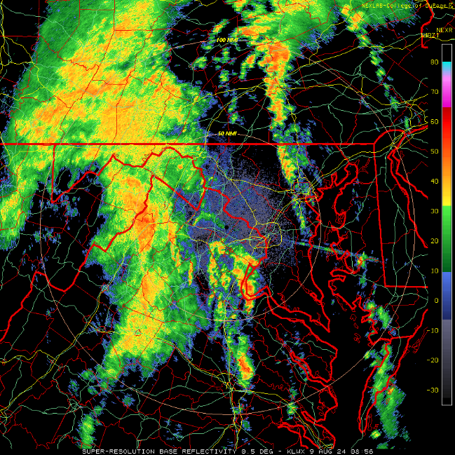
-
Just had the first real light-tower action in up nw. Some gusty winds as an overture, but the T&L didn't start kicking in until 15 minutes or so after the heavy rain commenced.
-
Random sampling of WU stations in my lil' corner of hell, all above 110 HIs, some over 115. Houston currently at 105 HI at the airport
-
It got more impressive as it did its thing. Some legit timpani-like thunder to round things off at the end.
-
Modest thunderstorm in up nw. I know it's severe warned, but nothing like that imby. Lot more T&L than yesterday, though.
-
Another breezy cloudburst with no thunder or lightning (so far; I thought I might have heard some distant thunder a few minutes ago). I mean, pouring, white rain, but only for a few minutes (again, so far). Must have been the fourth or fifth type of event like this in the past few weeks. And as soon as I wrap up posting, it's letting up.
-
Couple decent strikes in up nw. One of those storms that seems to rejuvenate itself. We had cloudbursitis about 15 minutes ago, and now another episode, with brightening skies to the west and north. I just love this kind of stuff. Must be frustrating to those who haven't cashed in on these unpretentious downpours recently. Now some slow-motion thunder. You can sense this storm is trying to make the major leagues, but it just doesn't have the tools to stick.
-
Got my copy of Grazulis' Significant Tornadoes 1974-2022 today! Subject of some mirth from other householders, but nerds gotta nerd.
-
Heavy rain shower in up nw. Again, like the past several, no T&L. (At least so far.)
-
I almost forgot what long-duration steady (to now downright heavy) rain was like. I can nearly see the tiny mouths on individual blades of grass opening as wide as they can. Downpour now with a little breeze. Almost like tropical remnants.
-
Yeah, me too. Any theories? Dews at DCA were in the mid-upper 60s this afternoon, SBCAPE from the IAD sounding @George BM posted may have been rather anemic ... This https://www.weather.gov/source/zhu/ZHU_Training_Page/lightning_stuff/lightning/lightning_strikes.html#:~:text=The glaciation process produces a,upper portions of the storm. defines one of the markers of "highly active" lightning is 3000 j/kg CAPE and we were nowhere near that, I think? I know it's not, "take a teaspoon of 65 dews and mix with bulk shear >30 kt" but why were these storms so ... ill-illuminating?
-
Severe fizzle warning for nw dc. The thunder sounds like the storm is rolling over and trying to get back to sleep, despite the severe weenies' entreaties to get up and get rowdy. If thunder can mutter, that's what I'm hearing
-
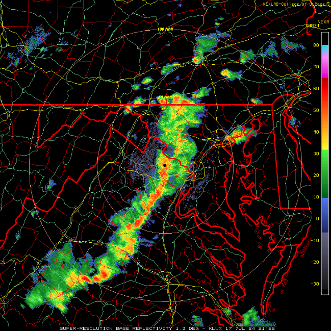
Meanwhile, in Rorschach-test related news, this snapshot of the incoming line could, in a different context, look like a highlighted topographical map of the California Sierras. Just flip the image and get rid of the all the irritating county and state lines, and overlay it onto a pristine map of eastern CA.
-
That's why I like at least two rounds -- one before and one after dark -- to solve the insuperable dilemma between wanting to see dramatic cloud structures, and a great light show.
- 1,696 replies
-
- 3
-

-
- severe
- thunderstorms
- (and 5 more)
-
Heh, because of the derecho, the low temp on 6.29.12 was just one degree warmer than normal.
-
Was this watch preceded by a MD? I took a spin around the SPC site and didn't see an mesoscale discussion for the mid Atlantic. Not that it's a precondition but I always like to read their reasoning.
- 1,696 replies
-
- 3
-
-
- severe
- thunderstorms
- (and 5 more)
-
I think my location may have gusted over 50 there. I'm not too far from Friendship Village and the warning specified 60 gust potential. Anyhoo, it's more or less over. Quintessential quick hitter.
- 1,696 replies
-
- 1
-
-
- severe
- thunderstorms
- (and 5 more)


