AccuChris
-
Posts
502 -
Joined
-
Last visited
Content Type
Profiles
Blogs
Forums
American Weather
Media Demo
Store
Gallery
Everything posted by AccuChris
-
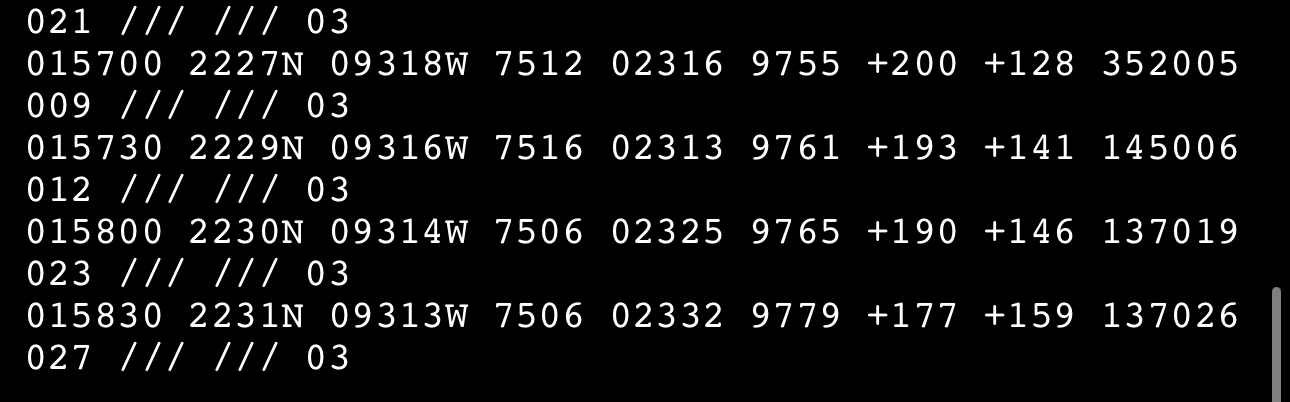
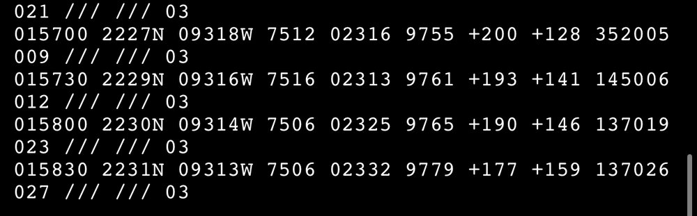
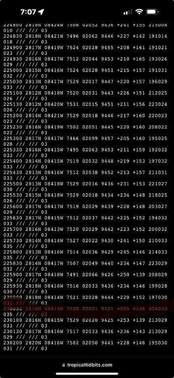
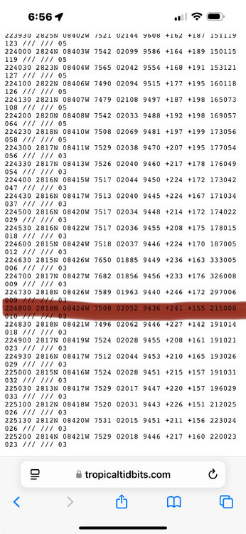
Latest recon pass found lowest pressure around 941mb .
-
New recon going through now just reported 975mb .
-
Latest recon 20 mins ago found 977mb .
-
2024 Atlantic Hurricane Season
AccuChris replied to Stormchaserchuck1's topic in Tropical Headquarters
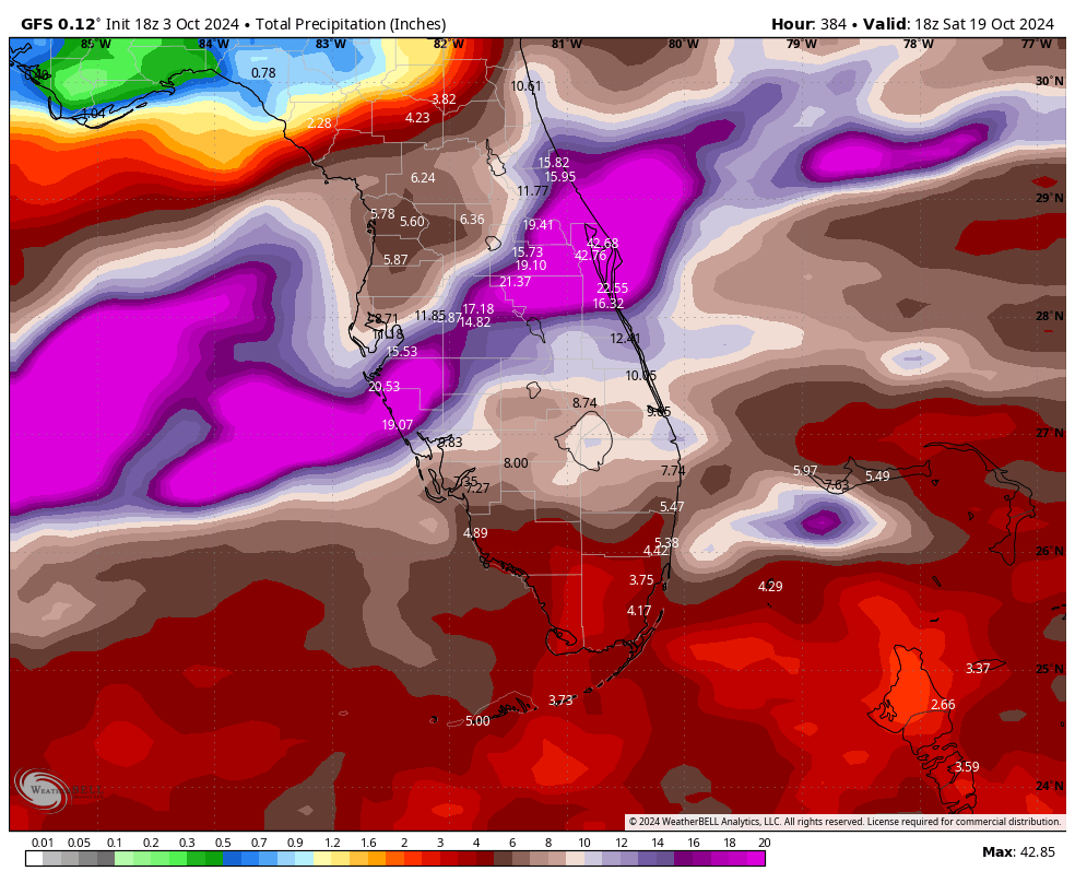
Obscene amount of rainfall being shown by the 18z GFS for Florida .
-
I think he said they were losing the roof of the structure they were broadcasting from and then they cut to break .
-
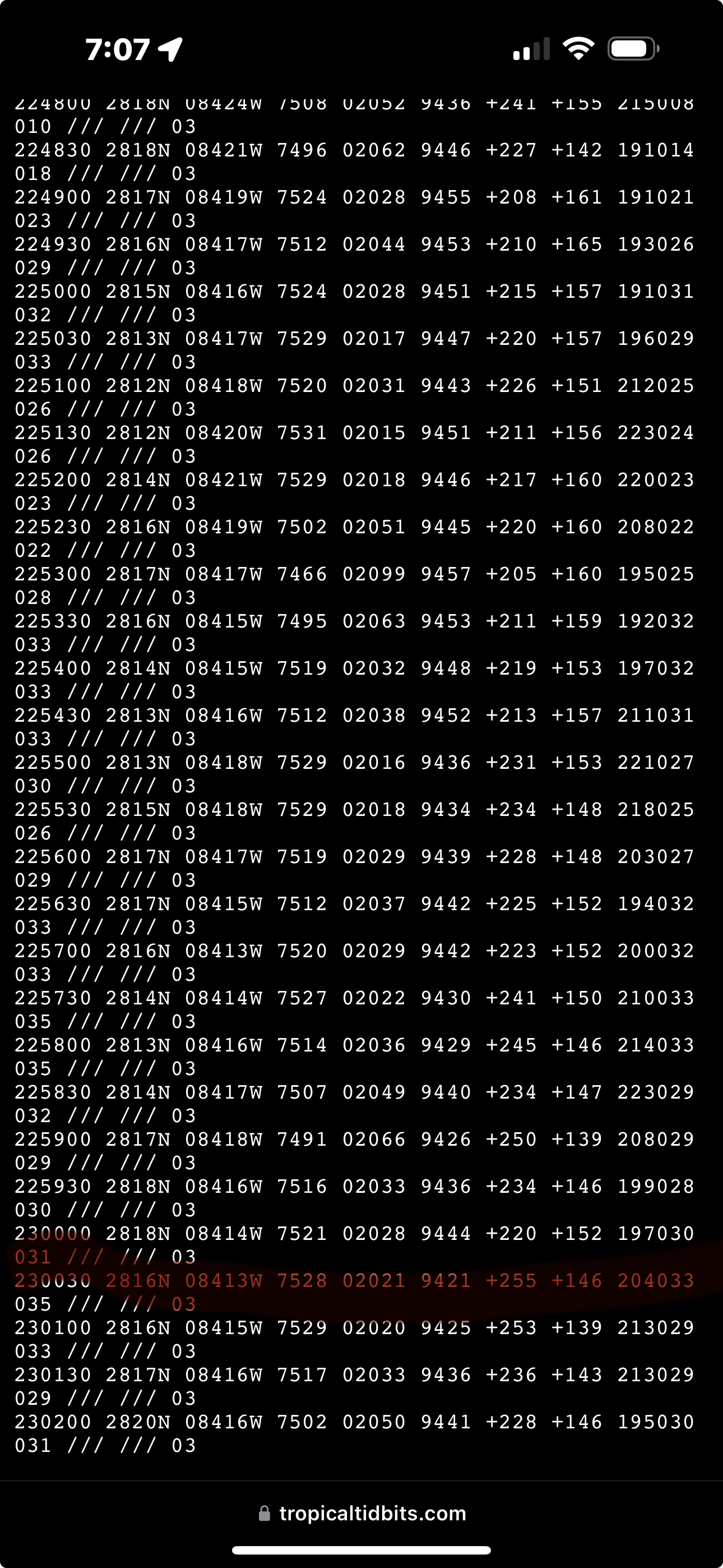
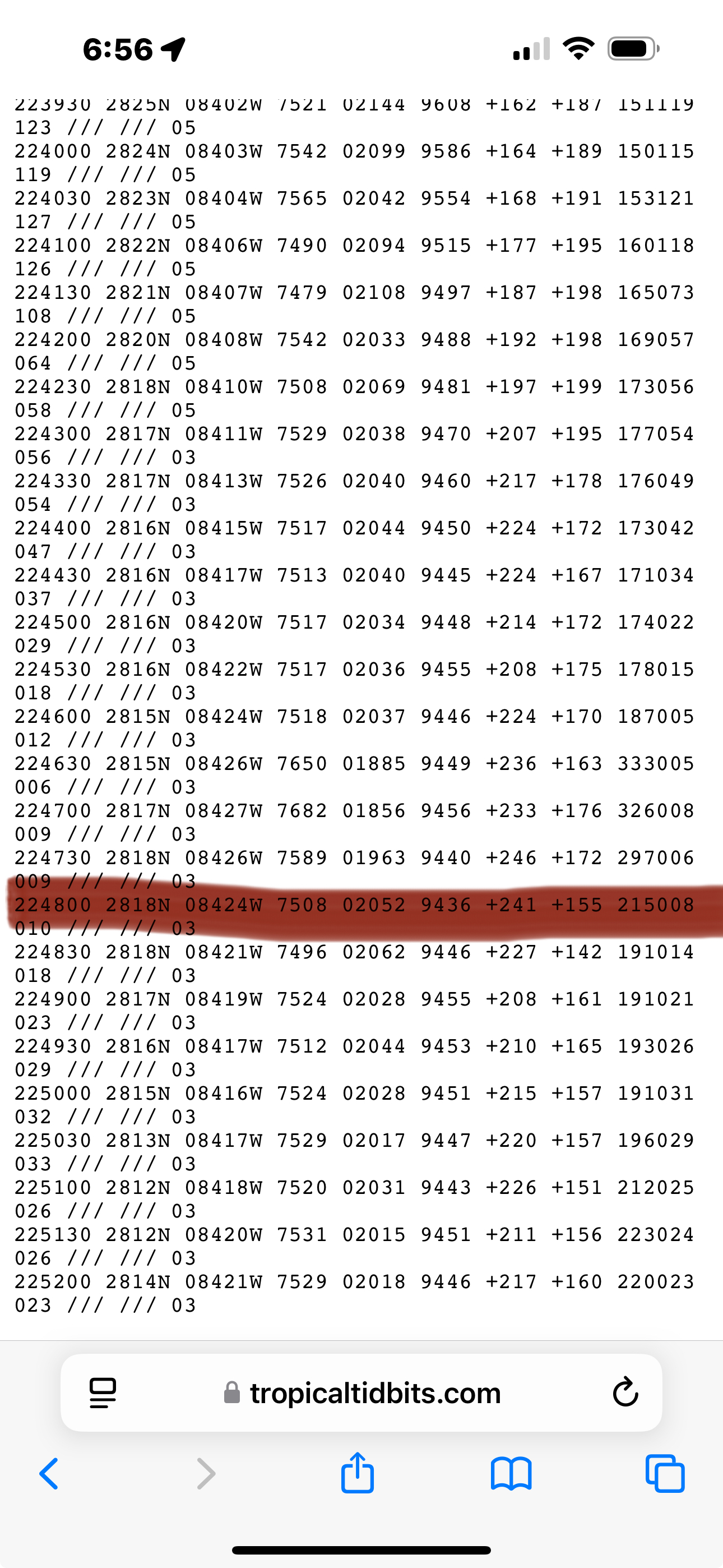
New pass shows pressure down to 942mb just after 7PM .
-
943mb just recorded about 10 mins ago on recons last pass through the eye .
-
Pressure down but they lowered winds at 6PM update? Interesting 000 WTNT64 KNHC 262200 TCUAT4 Hurricane Helene Tropical Cyclone Update NWS National Hurricane Center Miami FL AL092024 600 PM EDT Thu Sep 26 2024 ...HELENE CONTINUES HEADING FOR THE FLORIDA BIG BEND... ...TROPICAL STORM CONDITIONS SPREADING NORTHWARD ALONG THE WEST COAST OF FLORIDA... A slightly elevated Weatherflow station at the Skyway Fishing Pier near the entrance to Tampa Bay recently measured a sustained wind of 50 mph (80 km/h) and a gust to 69 mph (111 km/h). SUMMARY OF 600 PM EDT...2200 UTC...INFORMATION ---------------------------------------------- LOCATION...28.0N 84.5W ABOUT 115 MI...185 KM W OF TAMPA FLORIDA ABOUT 210 MI...335 KM SW OF TALLAHASSEE FLORIDA MAXIMUM SUSTAINED WINDS...120 MPH...195 KM/H PRESENT MOVEMENT...NNE OR 25 DEGREES AT 21 MPH...33 KM/H MINIMUM CENTRAL PRESSURE...950 MB...28.05 INCHES $$ Forecaster Bucci .
-
These zoomed in visible images are incredible to watch https://rammb-slider.cira.colostate.edu/?sat=goes-16&sec=mesoscale_01&x=685&y=1315&z=2&angle=0&im=60&ts=1&st=0&et=0&speed=130&motion=loop&maps%5Bborders%5D=white&maps%5Blat%5D=white&p%5B0%5D=band_02&opacity%5B0%5D=1&pause=20240925133125&slider=-1&hide_controls=1&mouse_draw=0&follow_feature=0&follow_hide=0&s=rammb-slider&draw_color=FFD700&draw_width=6 .
-
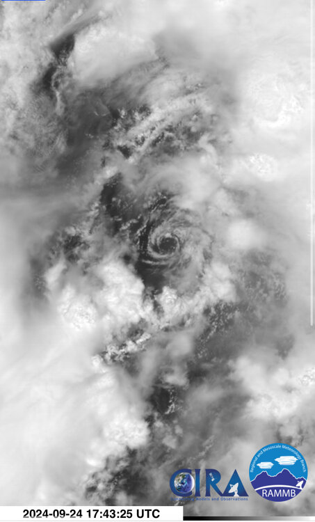
It looks like perhaps a warming eye may be starting right on the far eastern edge of the Yucatan .
-
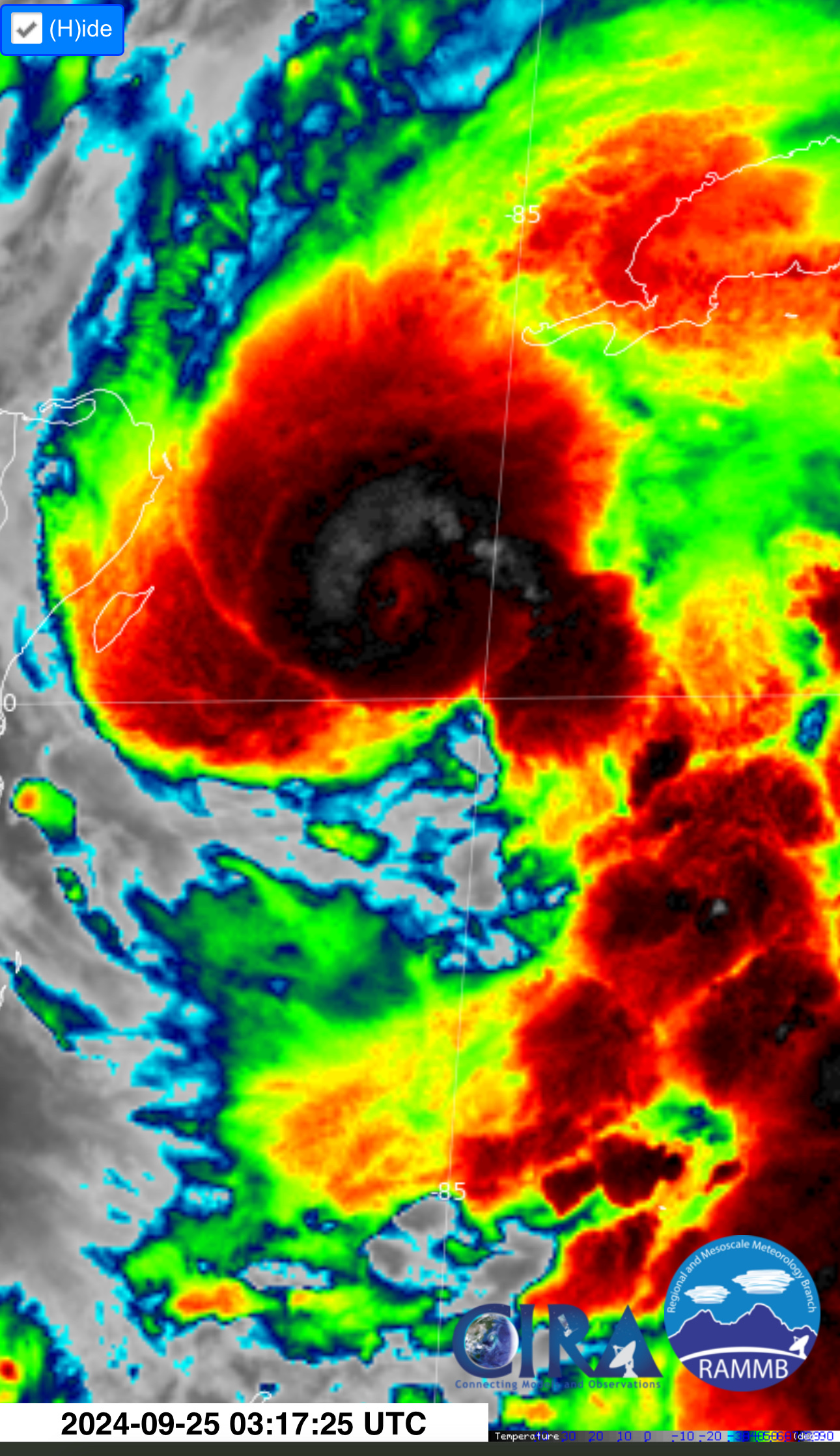
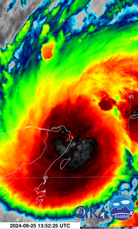
It certainly continues to look more and more impressive on IR .

-
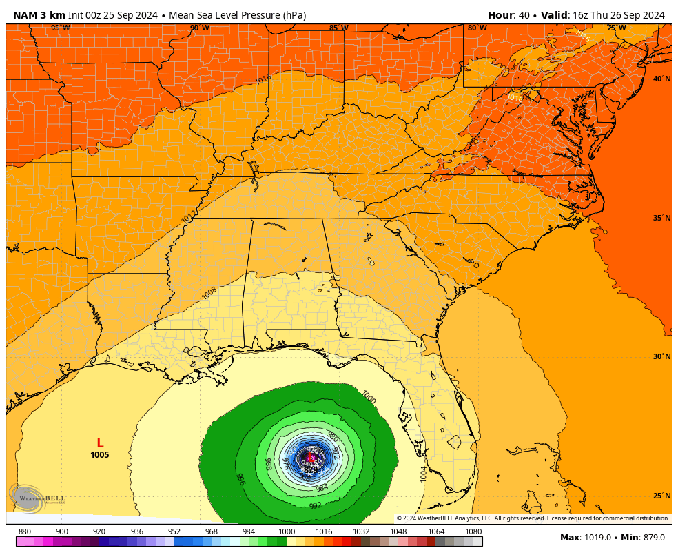
To your point it puts it at 879mb at its lowest point .

-
This is mesmerizing to watch in hi-def visible imagery .
-
Looks like perhaps a CDO is developing overtop the low level center. See how this evolves and persists overnight but this may be the beginning stages of this thing for real .
-
Looks like a hot tower is trying to fire near the low level center area. See how this all evolves over the next 12 hours or so https://www.star.nesdis.noaa.gov/GOES/meso_band.php?sat=G16&sat=G16&lat=17N&lon=81W&band=13&length=30 .
-
Potential Tropical Cyclone Eight—50mph/1006mb
AccuChris replied to WxWatcher007's topic in Tropical Headquarters
The 12z long range HRRR is running now, so lets see if it is consistent with itself from its 0z bullish run last night . -
Potential Tropical Cyclone Eight—50mph/1006mb
AccuChris replied to WxWatcher007's topic in Tropical Headquarters
Long range 0z HRRR indicating a Cat 1 hurricane Sunday . -
Officially a hurricane now. Pressure starting to tumble now 000 WTNT31 KNHC 102330 TCPAT1 BULLETIN Hurricane Francine Intermediate Advisory Number 9A NWS National Hurricane Center Miami FL AL062024 700 PM CDT Tue Sep 10 2024 ...FRANCINE BECOMES A HURRICANE... ...LIFE-THREATENING STORM SURGE AND HURRICANE-FORCE WINDS EXPECTED TO BEGIN IN LOUISIANA ON WEDNESDAY... SUMMARY OF 700 PM CDT...0000 UTC...INFORMATION ---------------------------------------------- LOCATION...25.8N 94.8W ABOUT 150 MI...240 KM E OF MOUTH OF THE RIO GRANDE ABOUT 350 MI...560 KM SW OF MORGAN CITY LOUISIANA MAXIMUM SUSTAINED WINDS...75 MPH...120 KM/H PRESENT MOVEMENT...NE OR 35 DEGREES AT 10 MPH...17 KM/H MINIMUM CENTRAL PRESSURE...982 MB...29.00 INCHES
-
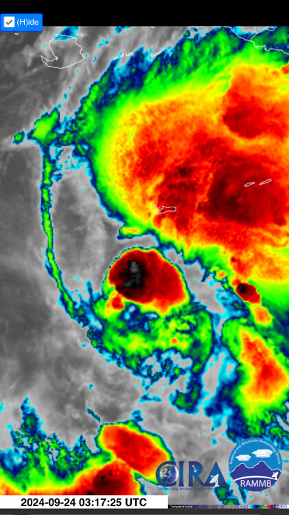
Pretty obvious on visible imagery an eye is trying to clear out
-
Only picked up 1.07” here in Lebanon since midnight. We definitely dodged the worst here compared to points to our north and west
-
1.73” in Lebanon so far and still a light rain here
-
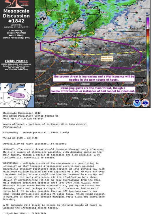
Sitting at a sultry 91/77 here in Lebanon after that cluster missed to our south. The main show is looking very feisty in central PA and will be curious how it evolves over the next few hours
-
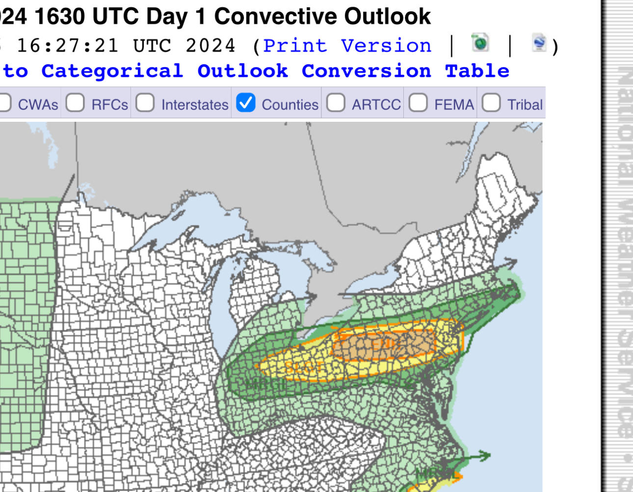
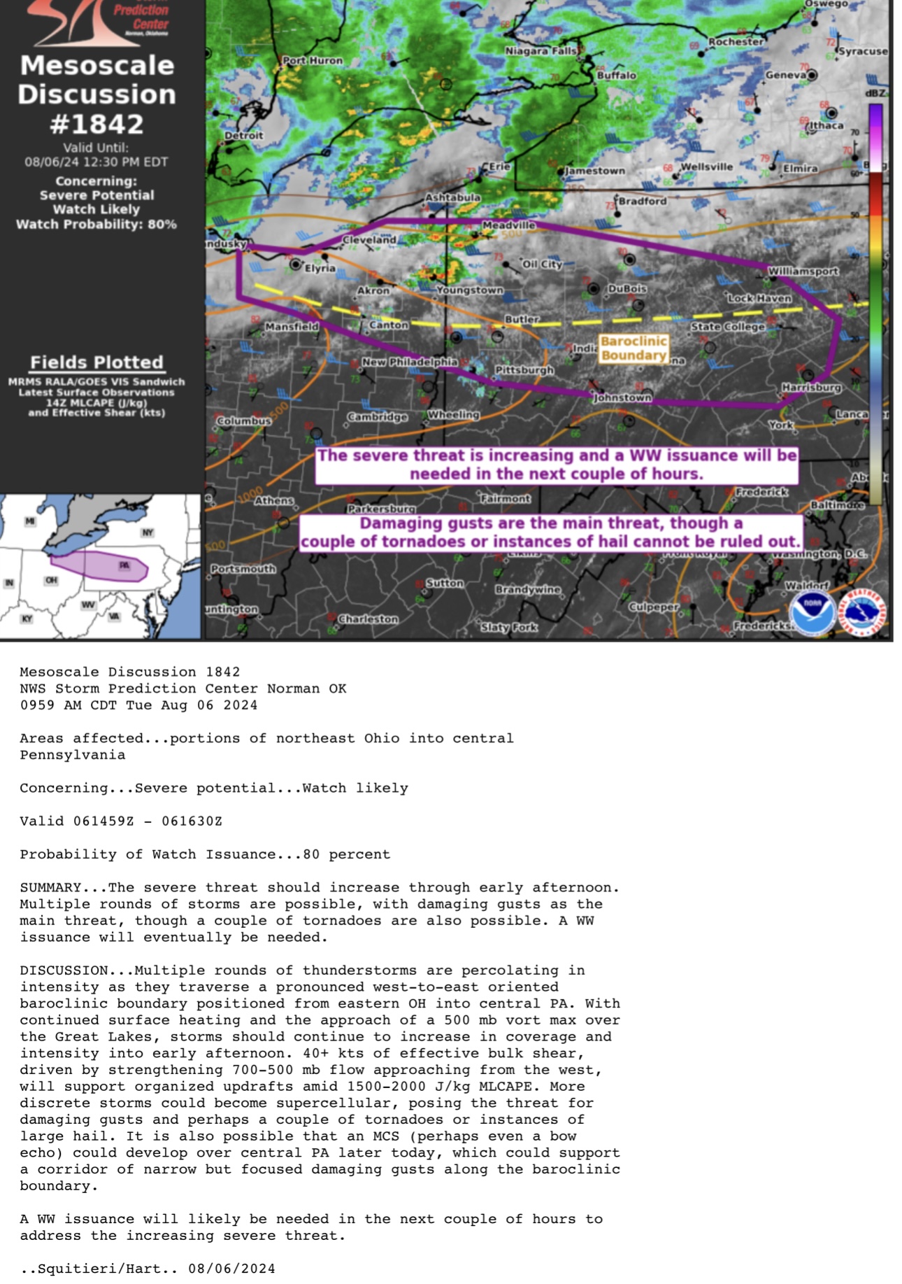
SPC has increased to an Enhanced Risk for today for much of the central zone of PA for damaging winds

-
Severe Thunderstorm Watch likely coming in the near future
-
As noted, an inner core is becoming more evident on recent radar loop. The question will be lingering dry air but if it can close up and develop deep convection it should steadily strengthen