BuffaloWeather
-
Posts
25,664 -
Joined
-
Last visited
Content Type
Profiles
Blogs
Forums
American Weather
Media Demo
Store
Gallery
Everything posted by BuffaloWeather
-

Major Lake Effect Snowstorm: Nov 29-Dec 4th
BuffaloWeather replied to BuffaloWeather's topic in Upstate New York/Pennsylvania
Day 2 recap with a ton of thundersnow! -
Yep, I’d take a weakened PV over a SSW anyday.
-
What a start to winter, up to 43” on the year already.
-
Major Lake Effect Snowstorm: Nov 29-Dec 4th
BuffaloWeather replied to BuffaloWeather's topic in Upstate New York/Pennsylvania
Another massive thundersnow! Clip (December 5 2024 at 257 AM).mp4 -
Major Lake Effect Snowstorm: Nov 29-Dec 4th
BuffaloWeather replied to BuffaloWeather's topic in Upstate New York/Pennsylvania
..4-DAY SNOWFALL REPORTS... Location Amount Time/Date Provider ...New York... ...Allegany County... 2 WSW Centerville 8.0 in 0915 AM 12/02 Trained Spotter West Almond 3.6 SW 6.1 in 0800 AM 12/02 COCORAHS Rushford 6.0 in 0545 AM 12/02 COOP Wellsville 2.4 ENE 5.0 in 0700 AM 12/02 COCORAHS Alfred 3.3 in 0700 AM 12/02 COOP ...Cattaraugus County... 1 N Perrysburg 53.7 in 1100 AM 12/02 CO-OP Observer Cattaraugus 3W 40.9 in 0700 AM 12/02 COOP Randolph 1.1 ENE 15.0 in 0830 AM 12/02 COCORAHS Franklinville 0.5 NNE 13.3 in 0815 AM 12/02 COCORAHS Ischua 0.4 SSE 11.9 in 0700 AM 12/02 COCORAHS Allegany State Park 5.3 in 0800 AM 12/02 COOP ...Cayuga County... Duck Lake 2.0 in 0800 AM 12/02 COCORAHS ...Chautauqua County... Cassadaga 54.2 in 0100 PM 12/02 Trained Spotter Dewittville 1.0 SSE 42.5 in 0600 AM 12/02 COCORAHS Fredonia 0.8 WNW 35.9 in 0500 AM 12/02 COCORAHS Dunkirk 1S 32.0 in 0700 AM 12/02 COOP Silver Creek 0.7 E 25.1 in 0800 AM 12/02 COCORAHS Kennedy 0.3 NE 11.5 in 0600 AM 12/02 COCORAHS Kennedy 2.6 SE 10.8 in 0800 AM 12/02 COCORAHS Falconer 0.3 WSW 9.2 in 0700 AM 12/02 COCORAHS Bemus Point 2.6 WSW 7.0 in 0700 AM 12/02 COCORAHS ...Erie County... 4 NE Angola 36.2 in 0600 AM 12/02 Trained Spotter Springville 5NE 34.6 in 0800 AM 12/02 COOP Wales 33.1 in 0700 AM 12/02 COOP 3 NE Holland 32.5 in 0600 AM 12/02 Trained Spotter 1 WNW Springville 29.4 in 0800 AM 12/02 COCORAHS Glenwood 1.0 SE 28.3 in 0700 AM 12/02 COCORAHS Orchard Park 27.6 in 1055 AM 12/02 Trained Spotter Boston 2.5 NE 26.7 in 0700 AM 12/02 COCORAHS Elma Center 1.8 SE 26.5 in 0700 AM 12/02 COCORAHS Glenwood 1.5 SE 26.5 in 0800 AM 12/02 COCORAHS 2 WNW East Aurora 24.8 in 0100 AM 12/02 Trained Spotter West Seneca 2.5 E 24.0 in 0800 AM 12/02 COCORAHS Hamburg 2.0 N 23.2 in 0754 AM 12/02 COCORAHS West Seneca 2.8 ENE 23.0 in 0700 AM 12/02 COCORAHS Lake View 1NE 22.1 in 0800 AM 12/02 COOP East Aurora 2.7 SSE 21.4 in 0700 AM 12/02 COCORAHS Eden 1.4 SSE 21.0 in 0700 AM 12/02 COCORAHS East Aurora 0.1 ENE 20.6 in 0700 AM 12/02 COCORAHS 2 NW West Falls 20.5 in 0821 AM 12/02 Trained Spotter Hamburg 0.4 WSW 19.3 in 0700 AM 12/02 COCORAHS Lackawanna 18.0 in 1015 PM 12/01 Trained Spotter 1 NW Alden 17.6 in 0700 AM 12/02 Trained Spotter Buffalo 3.7 SE 12.8 in 0700 AM 12/02 COCORAHS Angola 1.5 in 1101 AM 12/02 COCORAHS 1 SE Williamsville 1.2 in 0700 AM 12/02 Official NWS Obs Clarence Center 0.2 ESE 0.2 in 0700 AM 12/02 COCORAHS Clarence Center 0.9 N 0.1 in 0700 AM 12/02 COCORAHS Tonawanda 3.1 NE T in 0530 AM 12/02 COCORAHS Kenmore 0.3 ESE T in 0640 AM 12/02 COCORAHS Snyder 0.6 SW T in 0700 AM 12/02 COCORAHS Cheektowaga 2.4 NW T in 0700 AM 12/02 COCORAHS East Amherst 1.3 WSW T in 0759 AM 12/02 COCORAHS East Amherst 1.2 WNW T in 0845 AM 12/02 COCORAHS ...Genesee County... Alden 2.5 SE 23.2 in 0800 AM 12/02 COCORAHS 2 NNE Cowlesville 21.3 in 0800 AM 12/02 Trained Spotter Alexander 4.4 ESE 10.0 in 0800 AM 12/02 COCORAHS Pembroke 6.2 in 0532 AM 12/02 Trained Spotter Alexander 2.7 WNW 5.6 in 0700 AM 12/02 COCORAHS Batavia 3.4 WSW 4.0 in 0800 AM 12/02 COCORAHS Stafford 1.8 NE 1.1 in 0700 AM 12/02 COCORAHS Le Roy 1E 0.9 in 0730 AM 12/02 COOP Le Roy 0.7 ESE T in 0700 AM 12/02 COCORAHS ...Jefferson County... 4 SW Barnes Corners 65.5 in 0700 AM 12/02 Public Fort Drum 63.0 in 1100 AM 12/02 Public 5 SE Black River 52.8 in 0700 AM 12/02 Trained Spotter West Carthage 0.3 ENE 47.2 in 0700 AM 12/02 COCORAHS Adams 45.0 in 0820 AM 12/02 Broadcast Media Watertown 37.5 in 0800 AM 12/02 COOP Natural Bridge 30.0 in 1130 AM 12/02 Public Watertown 0.9 SSW 28.4 in 0645 AM 12/02 COCORAHS 3 W Calcium 26.0 in 1100 AM 12/02 Public Depauville 24.0 in 1125 AM 12/02 Public Theresa 21.0 in 1145 AM 12/02 Public Chaumont 10.5 in 1100 AM 12/02 Public ...Lewis County... 3 SW Copenhagen 65.9 in 1100 AM 12/02 Public 1 S Copenhagen 61.0 in 1100 AM 12/02 Public 1 NE New Bremen 46.0 in 0800 AM 12/02 Trained Spotter Lowville 40.0 in 1100 AM 12/02 Public Harrisville 40.0 in 1130 AM 12/02 Public 2 WSW Croghan 37.0 in 1130 AM 12/02 Public Lowville 35.0 in 0700 AM 12/02 COOP Chases Lake 17.8 in 0600 AM 12/02 COOP Glenfield 4.1 NNE 17.4 in 1000 AM 12/02 COCORAHS Highmarket 2W 14.0 in 0600 AM 12/02 COOP Constableville 1.2 NW 6.5 in 0500 AM 12/02 COCORAHS Brantingham 6.0 in 1130 AM 12/02 Public ...Livingston County... Dansville 3.6 WSW 1.1 in 0600 AM 12/02 COCORAHS ...Monroe County... 2 WNW Hilton 1.7 in 0700 AM 12/02 Trained Spotter Webster 3.0 W 0.5 in 0900 AM 12/02 COCORAHS Rochester 5.0 WNW 0.3 in 0700 AM 12/02 COCORAHS 3 SE Gates-North Gates 0.2 in 0700 AM 12/02 Official NWS Obs Rochester 5.7 W 0.1 in 0900 AM 12/02 COCORAHS Brockport 0.1 in 0900 AM 12/02 COOP Fairport 0.9 W T in 0640 AM 12/02 COCORAHS Pittsford 4.0 SSE T in 0700 AM 12/02 COCORAHS Scottsville 0.4 NW T in 0800 AM 12/02 COCORAHS ...Niagara County... Gasport 1.7 WSW 0.3 in 0700 AM 12/02 COCORAHS Sanborn 4NE T in 0700 AM 12/02 COOP Lockport 0.8 NE T in 0700 AM 12/02 COCORAHS Lockport T in 0700 AM 12/02 COOP Lockport 2.8 WNW T in 0805 AM 12/02 COCORAHS ...Ontario County... Bristol Harbour 0.6 in 0700 AM 12/02 COOP West Bloomfield 1S 0.5 in 0900 AM 12/02 COOP ...Orleans County... Medina 0.4 WNW T in 0800 AM 12/02 COCORAHS Medina T in 0800 AM 12/02 COOP ...Oswego County... Lacona 3.6 SSE 4.0 in 0700 AM 12/02 COCORAHS Palermo 2SSE 2.6 in 0600 AM 12/02 COOP Phoenix 7.0 NNE 2.6 in 0600 AM 12/02 COCORAHS Minetto 0.1 SE 2.0 in 0800 AM 12/02 COCORAHS Mexico 2SW 1.0 in 0600 AM 12/02 COOP West Monroe 1.6 NNE 1.0 in 0730 AM 12/02 COCORAHS ...Wayne County... Sodus 6.0 in 1100 AM 12/02 Public Wolcott 6.4 NW 4.7 in 0700 AM 12/02 COCORAHS Clyde 0.3 WNW T in 0600 AM 12/02 COCORAHS Macedon 2.6 ESE T in 0710 AM 12/02 COCORAHS Palmyra 1.6 NW T in 0750 AM 12/02 COCORAHS ...Wyoming County... Attica 7SW 24.6 in 0600 AM 12/02 COOP Silver Springs 3N 16.9 in 0700 AM 12/02 COOP Warsaw 4W 11.7 in 0700 AM 12/02 COOP Wyoming 3W 10.9 in 0700 AM 12/02 COOP Attica 4.3 in 0123 PM 12/02 Public && -
Major Lake Effect Snowstorm: Nov 29-Dec 4th
BuffaloWeather replied to BuffaloWeather's topic in Upstate New York/Pennsylvania
Totals so far https://kamala.cod.edu/ny/latest.nous41.KBUF.html ...STORM TOTAL SNOWFALL REPORTS... Location Amount Time/Date Provider ...New York... ...Allegany County... 3 WSW Centerville 8.0 in 0915 AM 11/30 Trained Spotter ...Cattaraugus County... Cattaraugus 34.5 in 0800 AM 12/01 CO-OP Observer ...Chautauqua County... Cassadaga 37.7 in 0600 AM 12/01 Trained Spotter Fredonia 27.0 in 0700 AM 12/01 Cocorahs Dunkirk 26.5 in 0800 AM 12/01 CO-OP Observer ...Erie County... 4 NE Angola 32.0 in 0739 AM 12/01 Trained Spotter Springville 29.1 in 0800 AM 12/01 CO-OP Observer 1 SE Glenwood 21.5 in 0800 AM 12/01 Public 2 N Hamburg 20.7 in 0800 AM 12/01 Cocorahs 2 WNW East Aurora 18.8 in 0847 AM 12/01 Trained Spotter 2 NW Colden 18.1 in 0745 AM 12/01 Cocorahs Lackawanna 18.0 in 0830 AM 12/01 Trained Spotter Orchard Park 18.0 in 0700 AM 12/01 Trained Spotter East Aurora 16.1 in 0800 AM 12/01 Cocorahs 2 N Marilla 16.0 in 1120 PM 11/30 NWS Employee 1 WNW Alden 15.8 in 0846 AM 12/01 Trained Spotter 1 NNW Hamburg 15.8 in 0430 AM 12/01 Public 2 NW West Falls 12.5 in 0819 AM 12/01 Trained Spotter 3 NNE Lackawanna 12.4 in 0800 AM 12/01 Cocorahs 2 SSE Williamsville 1.2 in 0700 AM 12/01 ASOS ...Genesee County... 3 WNW Alexander 4.0 in 0800 AM 12/01 Cocorahs Batavia 3.5 in 0800 AM 12/01 Cocorahs 2 E Stafford 0.2 in 0814 AM 12/01 Trained Spotter ...Jefferson County... 4 NW Copenhagen 46.0 in 0804 AM 12/01 Trained Spotter 4 SW Barnes Corners 46.0 in 0600 AM 12/01 Public 4 WSW West Carthage 41.0 in 0700 AM 12/01 Trained Spotter Watertown 25.1 in 0742 AM 12/01 Trained Spotter 1 S Calcium 24.3 in 0600 AM 12/01 Trained Spotter 1 SSW Deferiet 22.5 in 0737 AM 12/01 Trained Spotter ...Lewis County... Lowville 24.0 in 0800 AM 12/01 CO-OP Observer ...Wyoming County... 4 W Warsaw 19.8 in 0700 AM 12/01 CO-OP Observer Silver Springs 12.9 in 0800 AM 12/01 CO-OP Observer -
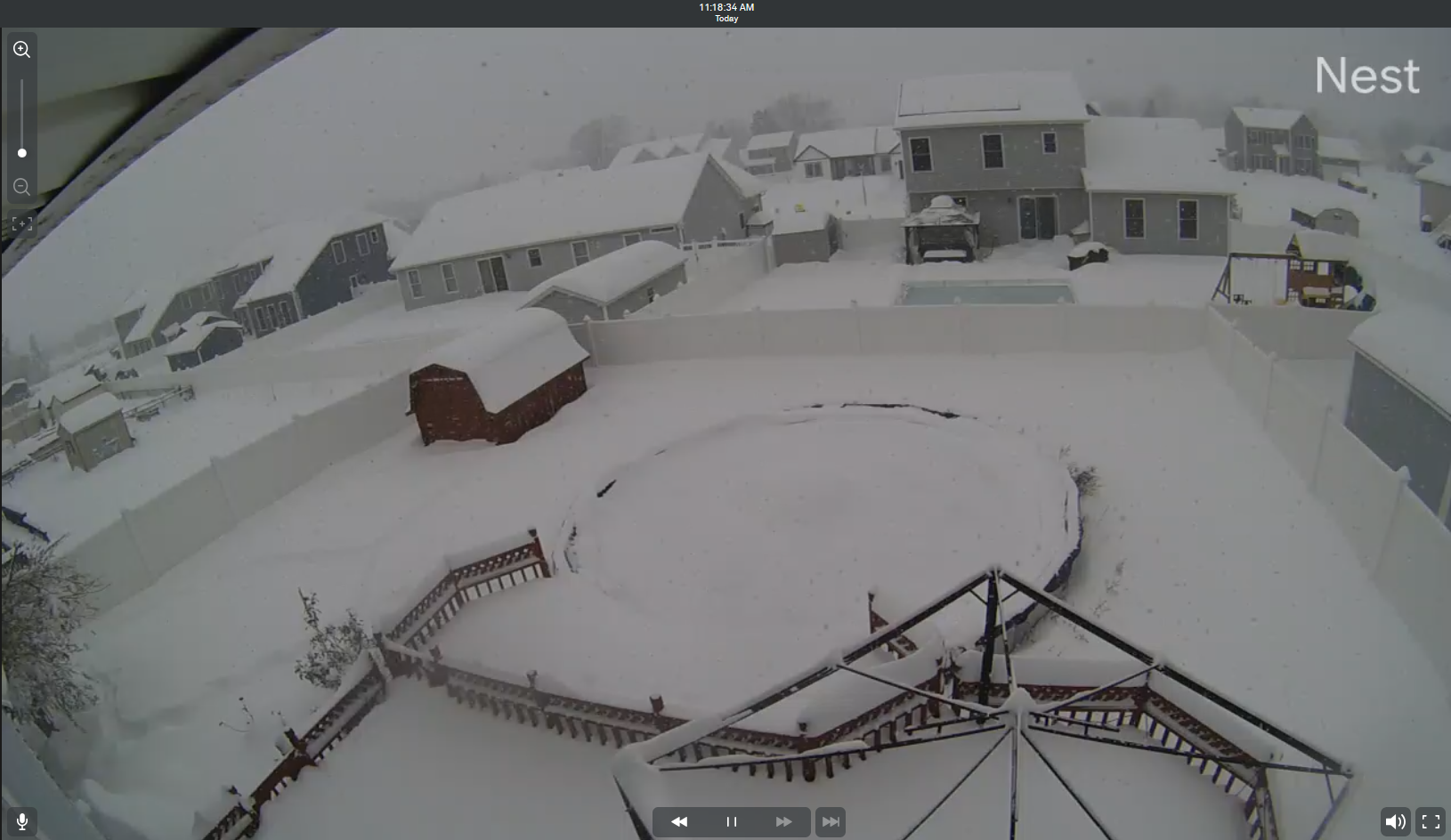
We got slammed Jeb! 31" in a day. Got this thundersnow on cam! thundersnow.mp4
-
Blowvember - and not named for wind potential
BuffaloWeather replied to Go Kart Mozart's topic in New England
That was me as a Kid growing up in the city and then near the airport. I always told myself when I get old enough to move out I'm going south! We got slammed, 31" in a day here. I got this video of thundersnow from my cam. thundersnow.mp4 -
Fall/Winter '24 Banter and Complaints Go Here
BuffaloWeather replied to IWXwx's topic in Lakes/Ohio Valley
We got smoked here, over 31" in a day, still snowing. Got this clip of thundersnow on my nest cam thundersnow.mp4 -
Major Lake Effect Snowstorm: Nov 29-Dec 4th
BuffaloWeather replied to BuffaloWeather's topic in Upstate New York/Pennsylvania
The old google nest cams, the new ones I'm not a fan of due to the software. I really like the old app/interface -
Major Lake Effect Snowstorm: Nov 29-Dec 4th
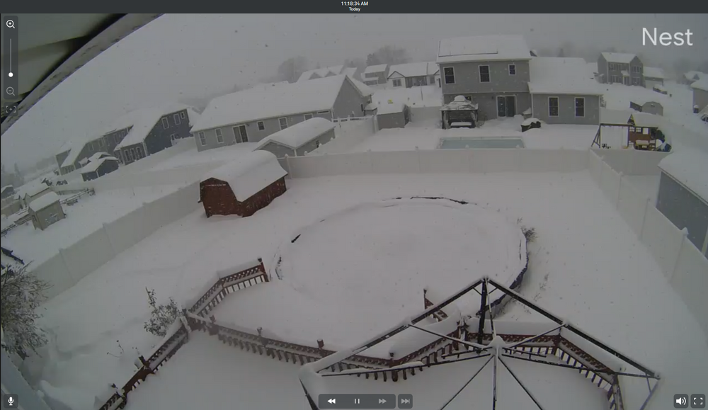
BuffaloWeather replied to BuffaloWeather's topic in Upstate New York/Pennsylvania
-
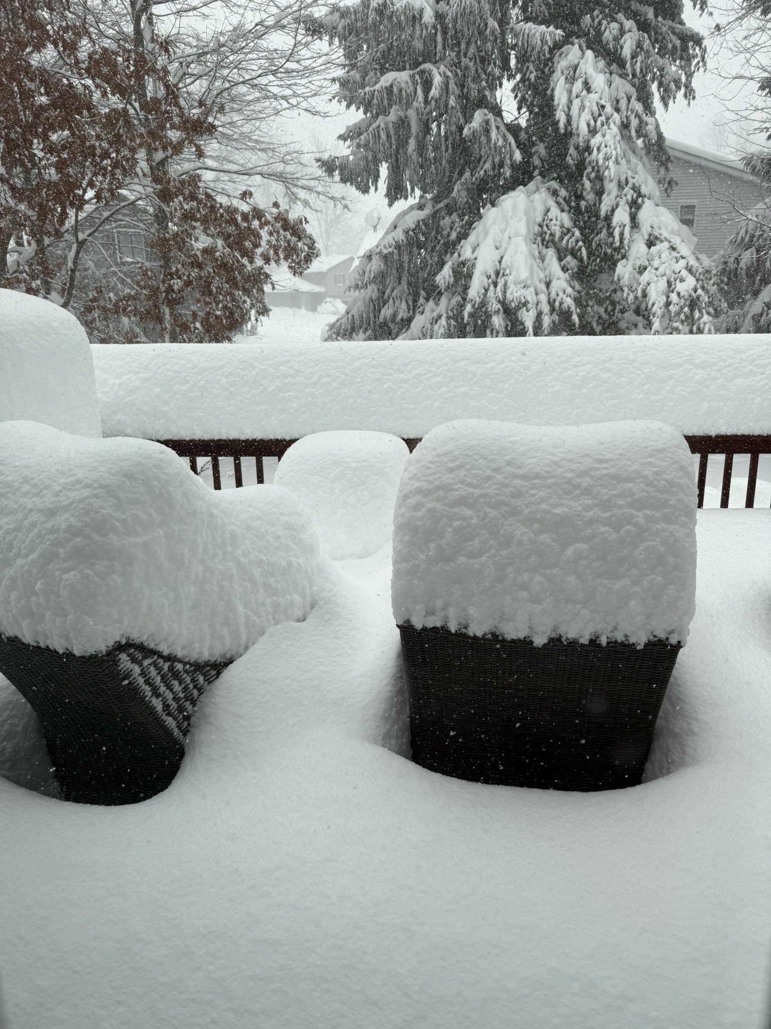
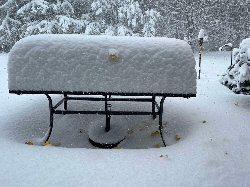
Got about 3 feet today, great start to winter
-
Major Lake Effect Snowstorm: Nov 29-Dec 4th
BuffaloWeather replied to BuffaloWeather's topic in Upstate New York/Pennsylvania
Getting destroyed 3" per, thundersnow! thundersnow.mp4- 61 replies
-
- 12
-

-
Major Lake Effect Snowstorm: Nov 29-Dec 4th
BuffaloWeather replied to BuffaloWeather's topic in Upstate New York/Pennsylvania
Around 20" on the ground and this is my point and click Tonight Snow. The snow could be heavy at times. Some thunder is also possible. Low around 23. Southwest wind 13 to 15 mph, with gusts as high as 26 mph. Chance of precipitation is 100%. Total nighttime snow accumulation of 18 to 24 inches possible. Sunday Snow before 1pm, then snow showers likely after 1pm. The snow could be heavy at times. High near 31. Southwest wind 13 to 15 mph. Chance of precipitation is 90%. New snow accumulation of 4 to 8 inches possible. Sunday Night Snow likely before 2am, then a chance of snow showers after 2am. Mostly cloudy, with a low around 25. West wind 6 to 13 mph. Chance of precipitation is 70%. New snow accumulation of 2 to 4 inches possible -
Major Lake Effect Snowstorm: Nov 29-Dec 4th
BuffaloWeather replied to BuffaloWeather's topic in Upstate New York/Pennsylvania
Getting slammed -
Major Lake Effect Snowstorm: Nov 29-Dec 4th
BuffaloWeather replied to BuffaloWeather's topic in Upstate New York/Pennsylvania
https://x.com/weather_buffalo -
Major Lake Effect Snowstorm: Nov 29-Dec 4th
BuffaloWeather replied to BuffaloWeather's topic in Upstate New York/Pennsylvania
January of this year had 81" in 4 days just north of me. I measured 77" -
Major Lake Effect Snowstorm: Nov 29-Dec 4th
BuffaloWeather replied to BuffaloWeather's topic in Upstate New York/Pennsylvania
Erie PA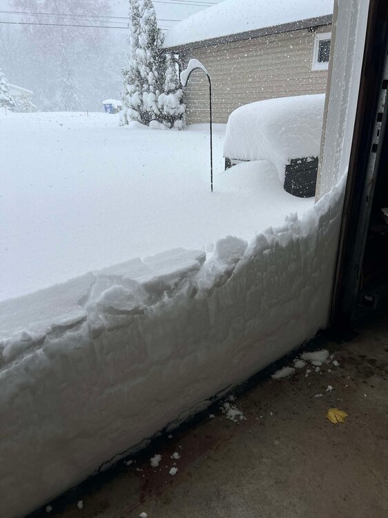

- 61 replies
-
- 12
-
-

-
Major Lake Effect Snowstorm: Nov 29-Dec 4th
BuffaloWeather replied to BuffaloWeather's topic in Upstate New York/Pennsylvania
The high end potential is insane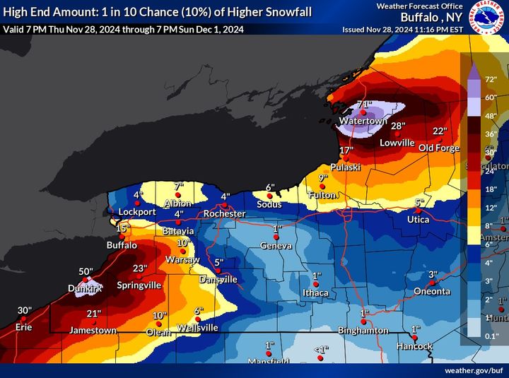
-
Major Lake Effect Snowstorm: Nov 29-Dec 4th
BuffaloWeather replied to BuffaloWeather's topic in Upstate New York/Pennsylvania
Youll be fine if you go around the band. You'll likely be fine if you drive up the I90 thruway as they usually plow that first but conditions will be rough. Good call to go around the band. I'll be at the game too! -
This is the storm to chase if any of you guys can make it to Watertown, decent sized city connected to I81.


-
New England Winter 2024-25 Bantering, Whining, and Sobbing Thread
BuffaloWeather replied to klw's topic in New England
This is the Lake Effect storm of the year if you can make it up to Lake Ontario near Watertown to chase. Pretty accessible area around the town with highways connecting the city to I81. @WxWatcher007has chased many times up there and can give you some details.
-
Major Lake Effect Snowstorm: Nov 29-Dec 4th
BuffaloWeather replied to BuffaloWeather's topic in Upstate New York/Pennsylvania
New map. 60-72" contour for Ontario
-
Major Lake Effect Snowstorm: Nov 29-Dec 4th
BuffaloWeather replied to BuffaloWeather's topic in Upstate New York/Pennsylvania
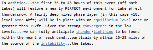
The entire thing is drool worthy, especially off Ontario .NEAR TERM /THROUGH FRIDAY NIGHT/... While there will be a lull in the weather early this evening... deepening cold air (H85 temps arnd -10c) in the wake of the exited storm system will combine with a fresh lobe of deep synoptic moisture to set the stage for the start of the much advertised lake effect snow event. A westerly flow of the cold air will encourage disorganized lake effect rain and snow to start over Chautauqua county during the evening hours. This lake induced convection will try to become better organized during the wee hours of Friday morning when there could even be a little thunder and lightning with the consolidating band. As is typically the case...the same will take place east of Lake Ontario some 3-6 hours later. Fresh snowfall amounts by daybreak will generally range from 1 to 3 inches across southern Chautauqua county and also over the Tug Hill plateau. As we push through Friday and Friday night...a highly amplified longwave pattern over North America will deliver the coldest airmass of the season so far...and this will support the start of what should turn out to be a classic and highly impactful lake effect snow event. Lake temperatures are near record warm after the warm fall season and will support extreme instability over the lakes through the event with lake induced equilibrium levels in the 15-20K foot range. The strong instability will very likely support thundersnow in the stronger bands. Expect peak snowfall rates of 2-3" per hour at times when the bands are at their strongest. West to WSW winds will gust to 25-35 mph at times. This will produce some typical blowing and drifting in open areas. Off Lake Erie... Lake effect snow will already be in place across Chautauqua county early Friday morning on westerly flow with bands of moderate to heavy snow that will become better organized as it will lift north during the course of the day. For the midday and afternoon...a resulting plume of moderate to heavy snow will extend from northern Chautauqua and southern Erie counties across Wyoming county. Daytime snow accumulations will range from 5 to 10 inches within this lake effect plume with the higher amounts being found on the Chautauqua ridge. The band will continue to become better organized Friday night while remaining in place from the Chautauqua county lakeshore across southern Erie county to Wyoming county. Snowfall rates of 1 to 3 inches an hour will be likely within the heart of this band with overnight snowfall forecast to range form a few inches across western Wyoming county to 8 to 14 inches from near Silver Creek across southern Erie county. Off Lake Ontario... Lake effect snow will be in the process of organizing and intensifying east of the lake early Friday morning. Westerly flow early will back to the WSW during the day, carrying a band of snow from the central and northern Tug Hill northward towards Watertown during the afternoon. The plume of increasingly focused lake snow should be fairly stationary between Watertown and the northern slopes of the Tug and the Watertown metro area Friday night. The quality of boundary layer moisture and instability strongly suggest this band will become quite intense at times with 3+ inch/hour snowfall rates possible. In addition...the first 36 to 48 hours of this event (off both lakes) will feature a nearly PERFECT environment for lake effect thundersnow. A fairly deep mixed phase layer (in this case -10c level arnd 4kft) will be in place with an equilibrium level near or greater than 15kft. Given the strong convergence in the low levels... we can fully anticipate thunder/lightning to be found within the heart of each band...particularly within 20-25 miles of the source of the instability...the lakes. && .SHORT TERM /SATURDAY THROUGH SUNDAY NIGHT/... ...LONG DURATION, HIGH IMPACT LAKE EFFECT SNOW TO CONTINUE THROUGH THE WEEKEND... The longwave pattern across North America will amplify over the weekend, with a ridge building along the US/Canadian Pacific Coast, forcing a longwave trough to deepen over central and eastern North America. This will deliver the coldest airmass of the season so far, with the synoptic setting prime for a long duration, significant lake effect snow event downwind of Lake Erie and Lake Ontario. Lake temperatures are near record warm levels after the warm fall season, and will support extreme instability over the lakes with lake induced equilibrium levels generally in the 15-20K foot range much of the time...and even a bit higher than that at times east of Lake Ontario. Coupled with a fairly deep mixed phase layer (in this case -10c level around 4kft) and strong low level convergence...this degree of instability may also support some thundersnow in the stronger bands...particularly east of Lake Ontario where the most intense lake snows are expected. A mid level closed low will continue to wobble about near James Bay through the first part of Saturday, in the classic position for a significant west to west-southwest flow event...with local pattern and CIPS analogs both suggesting a major, high impact lake effect snow event east of the lakes. After that time...the mid level closed low will elongate and break into two parts...with the larger and more dominant eastern portion breaking off towards Labrador...and the western portion and its embedded shortwave pivoting southeast across the central/eastern Great Lakes Saturday night and Sunday. This will induce changes in the low/mid level flow pattern such that winds will turn more northwesterly by Sunday night and Monday... thereby directing the lake snows to areas southeast of the lakes. When the bands are at their strongest...peak snowfall rates may reach 1-3" per hour at times east of Lake Erie...and to as high as 4+" per hour east of Lake Ontario. Westerly to west-southwesterly winds will also gust to 25-30 mph at times (most likely on Saturday)...leading to the typical blowing and drifting in open areas. With all that said...let`s dig a little deeper into the forecast details. Off Lake Erie... On Saturday, flow adjustments out ahead of the slowly approaching synoptic-scale trough axis and the effects of lake aggregate troughing will likely allow boundary layer flow to back to the west- southwest...carrying the band of lake effect snow northward through Erie County into the more immediate Buffalo Southtowns. There still remains some uncertainty with how far north the band will get, with the Canadian GEM still the farthest north amongst the guidance. Early season lake effect snow events with strong instability often end up farther north than much of the guidance, and with this in mind have nudged the band position yet a little further northward... with the latest forecast lying north of the ensemble mean and closest to the Canadian GEM position. Expect the band to reach its northernmost position sometime between Saturday afternoon and Saturday evening. There will be a very sharp cutoff to accumulating snow on the northern edge, as is often the case in this type of setup. Expect further adjustments to band position and intensity in the coming days as the details become more clear. On Sunday, boundary layer flow may still be west-southwesterly for the first half of the day, with a band possibly still over or near the Buffalo Southtowns. The aforementioned shortwave and attendant surface trough will then cross the eastern Great Lakes during the afternoon and early evening hours. Model soundings suggest that shear may increase over Lake Erie ahead of the shortwave/surface trough, which may allow for some weakening and broadening of the band. Later Sunday afternoon and Sunday night, boundary layer flow will rapidly veer to the northwest behind the trough, carrying the lake effect snow quickly southward into the western Southern Tier...where it will then remain through the rest of the period. Taking expected snowfall totals in the near term period also into account...expect storm totals through the end of the Short Term period to reach multiple feet in the most persistent bands. More precise storm totals will ultimately depend on how long the band can remain over one particular area, with more clarity in the coming days as the fine details of the forecast become more certain. This being said...at this point expect the highest totals across western Chautauqua, far northwest Cattaraugus, and southern/central Erie County. Off Lake Ontario... Saturday through Sunday expect the band to oscillate between Watertown and the northern Tug Hill region numerous times owing to subtle changes in the boundary layer flow direction. The quality of boundary layer moisture and instability suggest this band will likely become quite intense at times, with 4+ inch/hour snowfall rates and thundersnow possible at times. The band will remain in the same general area of the northern Tug Hill or near Watertown through most of Sunday. The mid-level shortwave will then cross the eastern end of Lake Ontario Sunday evening, with its associated surface trough crossing the lake and merging with the lake effect band...resulting in the latter getting carried quickly southward across the Tug Hill and into the Wayne- Northern Cayuga-Oswego County corridor overnight. Taking expected snowfall totals in the near term period also into account...expect storm totals east of Lake Ontario to also reach multiple feet in the most persistent bands...and to be higher than those east of Lake Erie. More precise storm totals will ultimately depend on how long the band can remain over one particular area, with more clarity in the coming days as the fine details of the forecast become more certain. This being said...as of now expect the highest totals across the northern Tug Hill region to near, or just southeast of Watertown. -
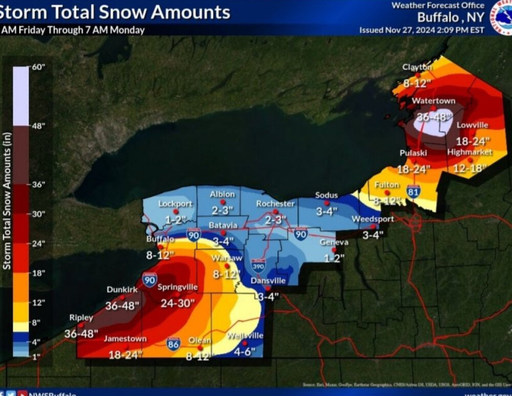
Major Lake Effect Snowstorm: Nov 29-Dec 4th
BuffaloWeather replied to BuffaloWeather's topic in Upstate New York/Pennsylvania
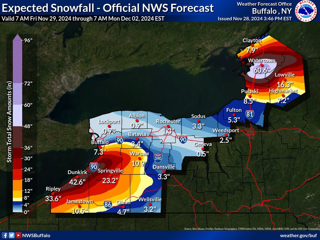
Forecasted totals through Monday morning