The Waterboy
-
Posts
989 -
Joined
-
Last visited
Content Type
Profiles
Blogs
Forums
American Weather
Media Demo
Store
Gallery
Everything posted by The Waterboy
-
MO/KS/AR/OK 2021-2022 Winter Discussion
The Waterboy replied to JoMo's topic in Central/Western States
Still sleet here. It’s been snowing 10 miles north and 10 miles west of me for the last hour. This is a game of inches. -
MO/KS/AR/OK 2021-2022 Winter Discussion
The Waterboy replied to JoMo's topic in Central/Western States
Same in Bentonville. Radar shows heavy snow just south and west of Tulsa. -
MO/KS/AR/OK 2021-2022 Winter Discussion
The Waterboy replied to JoMo's topic in Central/Western States
I didn’t see it on the radar either which was very odd. It was just enough to make some of the corners of rooftops white. -
MO/KS/AR/OK 2021-2022 Winter Discussion
The Waterboy replied to JoMo's topic in Central/Western States
MoWeatherGuy, similar to what StormDragon said above we just had short “burst” of snow showers within the last half hour. Hopefully that’s a positive sign that 850 temps are cold enough for all snow. We shall see… -
MO/KS/AR/OK 2021-2022 Winter Discussion
The Waterboy replied to JoMo's topic in Central/Western States
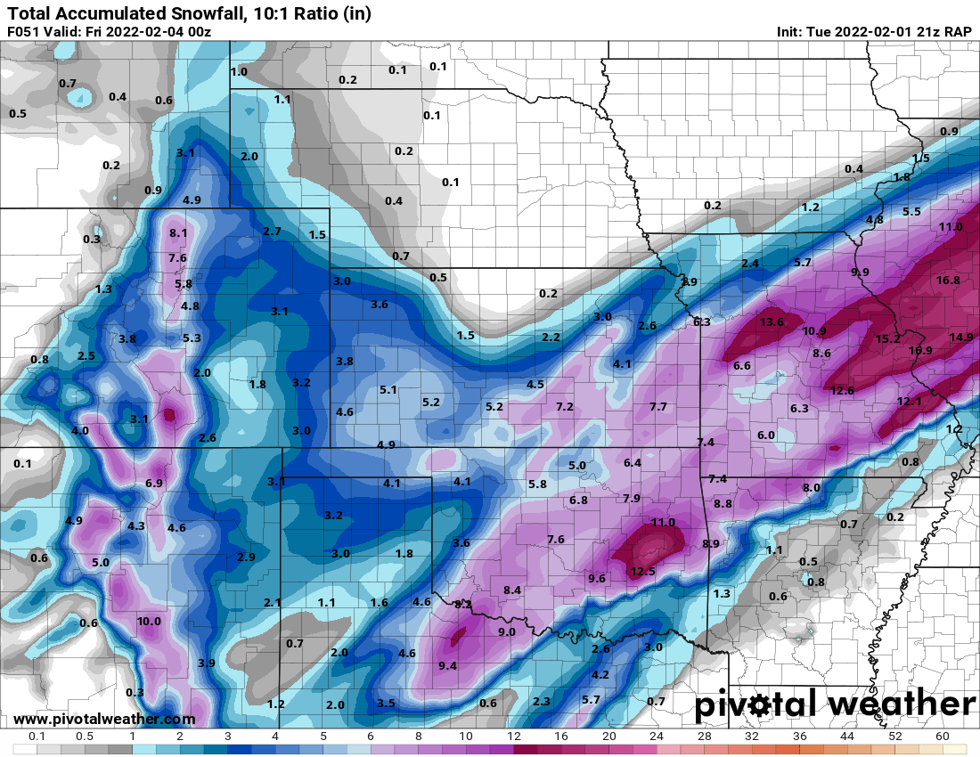
I’ll take the 03z RAP. -
MO/KS/AR/OK 2021-2022 Winter Discussion
The Waterboy replied to JoMo's topic in Central/Western States
Still significant differences between the NAM, HRRR, and RAP for Eastern/SE OK and Western AR.

-
MO/KS/AR/OK 2021-2022 Winter Discussion
The Waterboy replied to JoMo's topic in Central/Western States
18z GFS looks good too. Amounts slightly less than 12z. 18z NAM is the outlier for now. -
MO/KS/AR/OK 2021-2022 Winter Discussion
The Waterboy replied to JoMo's topic in Central/Western States
18z RGEM
-
MO/KS/AR/OK 2021-2022 Winter Discussion
The Waterboy replied to JoMo's topic in Central/Western States
Unfortunately this seems plausible considering the terrain issues. There’s going to be a sharp cutoff somewhere in our area. And then a dry slot on top of that. -
MO/KS/AR/OK 2021-2022 Winter Discussion
The Waterboy replied to JoMo's topic in Central/Western States
18z NAM shifted NW just a bit at hr42 -
MO/KS/AR/OK 2021-2022 Winter Discussion
The Waterboy replied to JoMo's topic in Central/Western States
12z GFS pretty much the same as the last two runs. Big event overall. -
MO/KS/AR/OK 2021-2022 Winter Discussion
The Waterboy replied to JoMo's topic in Central/Western States
12z NAM just went bonkers.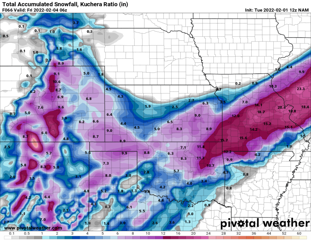
-
MO/KS/AR/OK 2021-2022 Winter Discussion
The Waterboy replied to JoMo's topic in Central/Western States
The NAM does seem to lose the 2nd wave of snow for Thursday like the 12z GFS did. -
MO/KS/AR/OK 2021-2022 Winter Discussion
The Waterboy replied to JoMo's topic in Central/Western States
00z NAM shifted SE again out to hr57. -
MO/KS/AR/OK 2021-2022 Winter Discussion
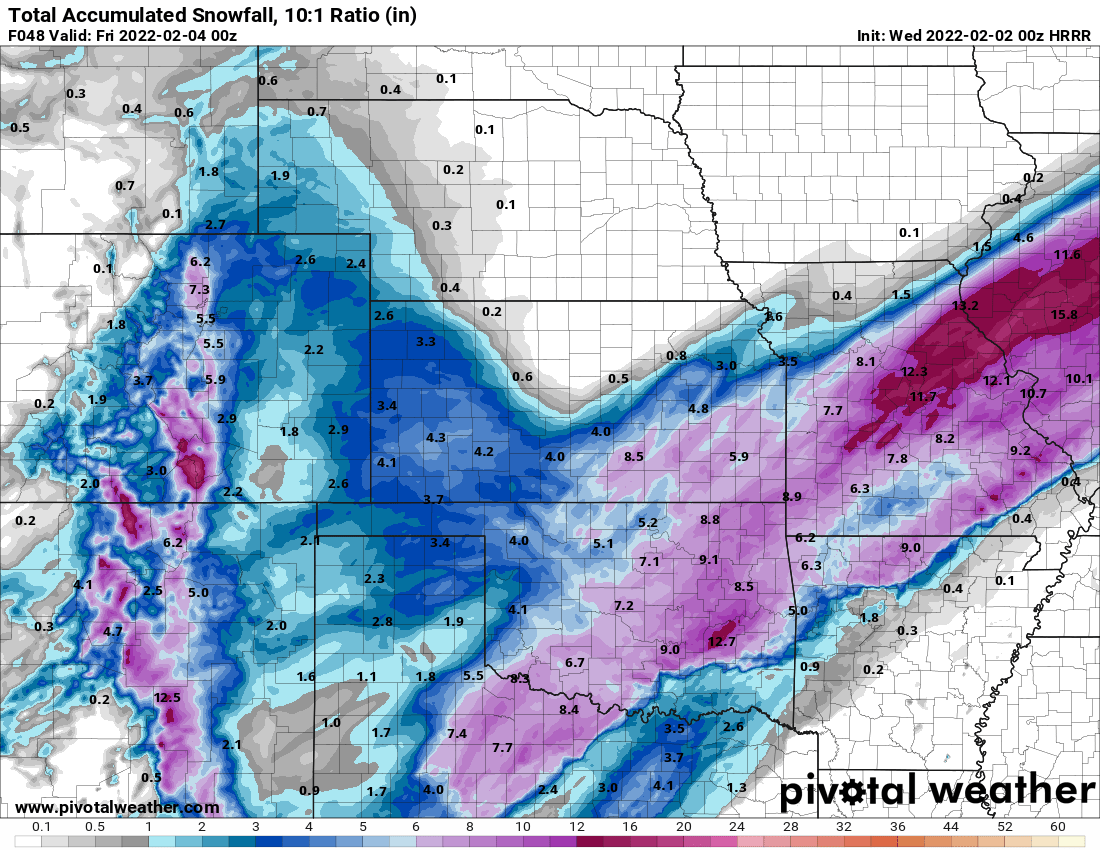
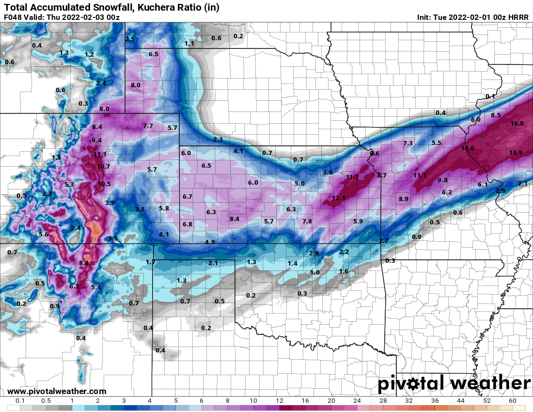
The Waterboy replied to JoMo's topic in Central/Western States
00z HRRR Kuchera snowfall at hr48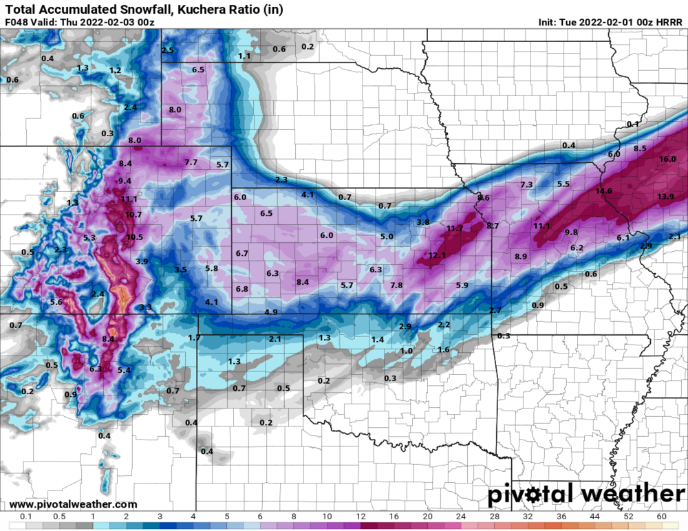
-
MO/KS/AR/OK 2021-2022 Winter Discussion
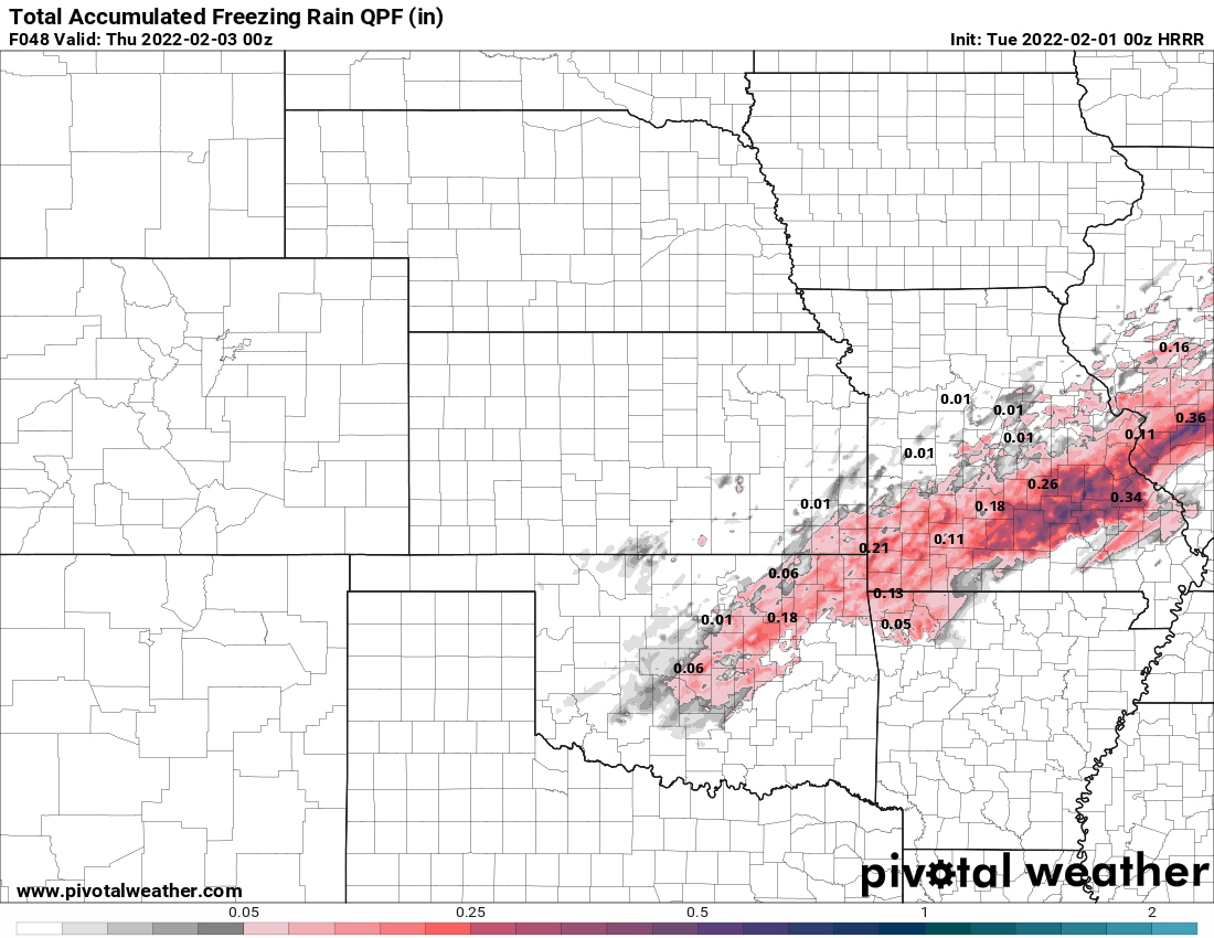
The Waterboy replied to JoMo's topic in Central/Western States
00z HRRR freezing rain at Hr48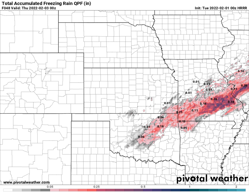
-
MO/KS/AR/OK 2021-2022 Winter Discussion
The Waterboy replied to JoMo's topic in Central/Western States
12z Euro further SE out to 60. Should be a good run for us. -
MO/KS/AR/OK 2021-2022 Winter Discussion
The Waterboy replied to JoMo's topic in Central/Western States
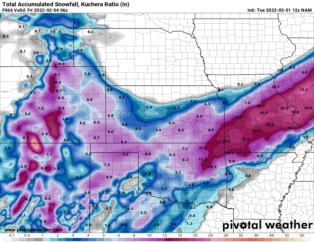
Fairly significant shift SE on GFS from 00z to 12z. Pivotal Kuchera maps shows: TULSA 00z - 3.6” 06z - 13.4” 12z - 15.2” JOPLIN 00z - 9.0 06z - 10.1 12z - 12.7 BENTONVILLE 00z - 2.5 06z - 4.6 12z - 9.8 FAYETTEVILLE 00z - 1.8 06z - 4.7 12z - 5.6 I think Chazer just posted the Weather Bell map so the totals might be off a bit but we all get the gist of the SE shift. EDIT: Nice shift SE on the GEFS ensemble too. -
MO/KS/AR/OK 2021-2022 Winter Discussion
The Waterboy replied to JoMo's topic in Central/Western States
12z NAM looks a tick or two SE out to 51. Much more snow in Kansas. -
MO/KS/AR/OK 2021-2022 Winter Discussion
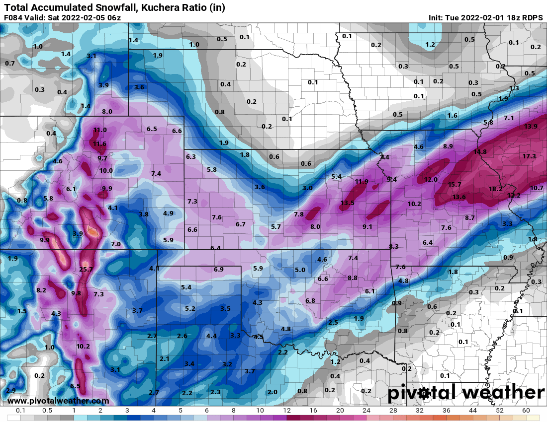
The Waterboy replied to JoMo's topic in Central/Western States
06z RDPS also nudged eeeeveeeer so slightly SE. 12z NAM out to 12 now. Today is the day we really want to start seeing things change back to our favor. -
MO/KS/AR/OK 2021-2022 Winter Discussion
The Waterboy replied to JoMo's topic in Central/Western States
Thanks StormChazer for the maps. Currently I would say the NWS Tulsa map above is the most likely scenario for those of us in NW AR based on current model runs. As most of us have heard before cold, shallow air typically has a very difficult time oozing through the Ozark and Boston Mountains. This begins pretty much at the Benton/Washington County line in Arkansas and struggles to push south of there. The models seem to depict that pretty well with the surface temp projections. I recall previous ice/sleet storms where portions of far NW Benton Co (Gravette) are snow while a few miles SE is sleet. Not sure if any of that is helpful. Unfortunately I’m not super knowledgeable on the 850mb piece of things that JoMo has mentioned a few times so I can’t speak to that part too much. The 18z maps above are marginally better than the GFS was. Looks like there will be a very sharp cutoff for some of us. Those of you in SW MO and Tulsa/north are probably in the sweet spot for more snow accumulations. Let’s hold out hope the 00z runs shift back SE a bit. -
MO/KS/AR/OK 2021-2022 Winter Discussion
The Waterboy replied to JoMo's topic in Central/Western States
Any good news from the 18z Euro? I’m almost afraid to ask. -
MO/KS/AR/OK 2021-2022 Winter Discussion
The Waterboy replied to JoMo's topic in Central/Western States
Definitely not trending in our favor to stay out of an ice storm. -
MO/KS/AR/OK 2021-2022 Winter Discussion
The Waterboy replied to JoMo's topic in Central/Western States
Good to hear the 06z was better. The 00 Euro was definitely the outlier so far. The trend still continues for a major event in our area. -
MO/KS/AR/OK 2021-2022 Winter Discussion
The Waterboy replied to JoMo's topic in Central/Western States
The 00z Canadian is absolutely bonkers for pretty much all of us! The Kuchera snow maps are nuts.