

The Waterboy
-
Posts
989 -
Joined
-
Last visited
Content Type
Profiles
Blogs
Forums
American Weather
Media Demo
Store
Gallery
Everything posted by The Waterboy
-
MO/KS/AR/OK 2019-2020 Winter Wonderland Discussion
The Waterboy replied to JoMo's topic in Central/Western States
Where are you located? -
MO/KS/AR/OK 2019-2020 Winter Wonderland Discussion
The Waterboy replied to JoMo's topic in Central/Western States
NWS Tulsa updated the graphic. Looks more realistic now. Fayetteville is 1.2 inches. -
MO/KS/AR/OK 2019-2020 Winter Wonderland Discussion
The Waterboy replied to JoMo's topic in Central/Western States
Will also be interesting to see how much wet bulbing occurs once precip starts. -
MO/KS/AR/OK 2019-2020 Winter Wonderland Discussion
The Waterboy replied to JoMo's topic in Central/Western States
Tulsa AFD not biting on the 18z NAM. Would love for them to be wrong. A brief window of wintry precip remains likely late Friday night through early Saturday along the western periphery of the precip shield. Sfc temps will not be overly cold behind this initial frontal passage and precip intensity will be diminishing with time. Also precip type will likely be highly variable with the expectation that sleet or light snow will dominate the longest. Both icing and sleet / snow accumulations are forecast to remain light and any impacts likely confined to elevated road surfaces. The 18z NAM may receive some attention for those hoping for more snow however it remains a large outlier and related SREF trends are not optimistic for such a large forecast adjustment. -
MO/KS/AR/OK 2019-2020 Winter Wonderland Discussion
The Waterboy replied to JoMo's topic in Central/Western States
Are we throwing in the towel for seeing anything substantial tomorrow night/Saturday morning? Canadian seems to be the only model still giving us any hope. -
MO/KS/AR/OK 2019-2020 Winter Wonderland Discussion
The Waterboy replied to JoMo's topic in Central/Western States
00z NAM came in a bit colder for what it's worth...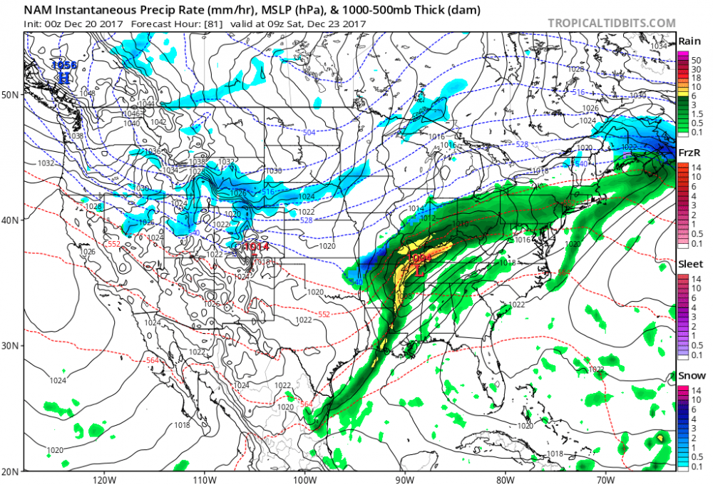
-
MO/KS/AR/OK 2019-2020 Winter Wonderland Discussion
The Waterboy replied to JoMo's topic in Central/Western States
The 12z Canadian also looks very similar. Very positive trend. Models typically don't handle Arctic air masses all that well either. -
MO/KS/AR/OK 2019-2020 Winter Wonderland Discussion
The Waterboy replied to JoMo's topic in Central/Western States
Loving the name change to GSwizzle! Welcome back. You're either our good luck or kiss of death! We shall see. Either way I'm giving you the credit/blame. -
MO/KS/AR/OK 2019-2020 Winter Wonderland Discussion
The Waterboy replied to JoMo's topic in Central/Western States
I prefer the GFS being a little bit south of us this far out. If history repeats itself we will no doubt have the NW shift a few hundred miles. Normally when I'm in the bullseye this far out it shifts to an I-44 storm. Temps on the Canadian look meh but a better track. Lets see what the Euro shows shortly. Hopefully it's better then the 00z run. Still plenty of options on the table. -
MO/KS/AR/OK 2019-2020 Winter Wonderland Discussion
The Waterboy replied to JoMo's topic in Central/Western States
12z GEM looks great @ 240. Snow breaking out from Wichita Falls, TX up through OK into very NW AR and SW MO. -
MO/KS/AR/OK 2019-2020 Winter Wonderland Discussion
The Waterboy replied to JoMo's topic in Central/Western States
06 GFS was back. Nasty storm for Christmas Eve/Christmas Day. Wow!!! -
MO/KS/AR/OK 2019-2020 Winter Wonderland Discussion
The Waterboy replied to JoMo's topic in Central/Western States
Definitely more interesting and fun to have something to watch. I think we all can agree that an ice storm isn't what we want especially right at Christmas. Hard to say this far out if the cold air is shallow and stalls out around the Ozark Mountains. The GFS has hinted at that recently with the strong SER We shall see And if I remember correctly, JoMo has stated previously that a -EPO is our most crucial teleconnection for wintry weather. Even with a +NAO. -
MO/KS/AR/OK 2019-2020 Winter Wonderland Discussion
The Waterboy replied to JoMo's topic in Central/Western States
Joe Bastardi stated in his daily video he believes Dec 23-28 is going to be "very cold" in the Plains and Southern Plaines. GFS doesn't show this as of now. Will be interesting to see if he's correct. Hopefully the retrogression of the trough back to the west comes to fruition. Would be nice to have a cold Christmas this year. -
MO/KS/AR/OK 2019-2020 Winter Wonderland Discussion
The Waterboy replied to JoMo's topic in Central/Western States
JoMo's been awfully silent as well which probably isn't a good sign. He may still mourning over the collapse of the KC Chiefs. May they rest in peace... -
MO/KS/AR/OK 2019-2020 Winter Wonderland Discussion
The Waterboy replied to JoMo's topic in Central/Western States
12z GFS = Brrrrrrrrrrrrrrrrrr... -
MO/KS/AR/OK 2019-2020 Winter Wonderland Discussion
The Waterboy replied to JoMo's topic in Central/Western States
That will be fun to look at for a few more hours until the 18z run. Awesome stuff right there!!!! -
Central/Western Medium-Long Range Discussion
The Waterboy replied to andyhb's topic in Central/Western States
Steve, I am a novice at best so I read mainly and post very little. No need to clutter up the threads with pointless chatter. But I do have a question if you have time to educate those of us who aren't experts. What exactly are the Day 11+ Analogs? What data are they pulled from? And do you have a feel for how reliable the data is? Thanks in advance for the lesson. I always enjoy your posts. They are informative with the facts and appear to be unbiased. Thanks.

