suzook
-
Posts
675 -
Joined
-
Last visited
About suzook

-
Kept hearing about how the humidity was gonna be lower today....88 degrees, with a DewPoint of 82...WTF. Terrible out today.
-
Wet, humid summer. Making up for the 8 month drought. When does the next drought start? Seems like its all or nothing the last few years.
-
95 degrees 15 mins ago, pouring rain in a storm, down to 83!!! Picked up a quick quarter inch so far. Florida like weather here in the ATL area the last month. Strange.
-
My buddy in central NJ hit 106
-
Been in the upper 90's the last 3 days, with high dews. Reel feels 115-120. This is the most humid month i have seen the last 3 years I have lived here. Its usually not prolonged like this in my area. More of the same the next couple weeks.
-
90, real feel of 109 this afternoon. Just had a quarter inch of rain drop with some storms. Much cooler now.
-
I like 100. Yes, I'm weird.
-
Wow!! Finally cashing in. That's great!
-
Another cloudy dreary day. I can't believe how stuck in this cloudy wet pattern we have been in here. About a month so far. Depressing.
-
Picked up a quarter inch after midnight, with more storms incoming. I mean, could someone turn off the rain machine in my area please?? Send it east where it's still needed.
-
Thankfully the storm wasn't bad at all here. Picked up an inch and a half of rain. We did have a 50mph gust in a Tstorm, but other than that it was barely windy. I see many areas to my east got much more rain and wind. There were reports of a tornado touchdown though in that Tstorm. Hoping areas that REALLY needed some rain have cashed in.
-
Just picked up a half inch of rain in 10 min storm. 50 mph gust just blew shit across my yard. Shit is gonna be bad. Edit, rotation noted half mile from me during that storm.
-
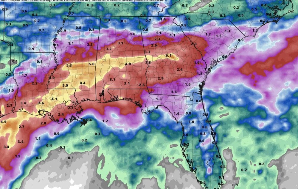
Currently breezy and 75 with humid conditions. I sure hope the places that need some rain can cash in with this tropical system. We don't need anymore at this point, take some please. Expecting 4 to 5 inches this afternoon through tomorrow morning. Hopefully the wind isn't too bad. Really soaked soil, with some wind could take some trees down this evening.
-
Hit a high on 69 today!!!! Half inch of rain so far. Miserable day. More of the same until the weekend.
-
Raining again today in ATL area. Apperantly it's rains every day now here. All or nothing.