NVAwx
-
Posts
23 -
Joined
-
Last visited
Content Type
Profiles
Blogs
Forums
American Weather
Media Demo
Store
Gallery
Everything posted by NVAwx
-
Since Friday?
-
Lynchburg, Martinsville, Appomattox, Keysville, Eden, Yanceyville, Danbury, Amherst, South Boston, and Danville
-
Winter Commuting Hazard coming for the immediate metro area?
-
Yeaaah this ain't good for the DMV. But enjoy RVA and 757!
-
Can’t lose what you never had. Bless his heart.
-
Precipitation is forecast to exit the region on Monday , but river flooding could linger through Monday evening as water slowly drains through the river system. Below normal temperatures and mostly dry conditions are favored through the middle parts of next week. The next chance for precipitation will be Wednesday into Thursday when a coastal low may bring coastal low to the region with wintry precipitation possible. - LWX discussion (2/13/25 @ 2:41 pm) FUJIWHARA!?!
-
https://www.wpc.ncep.noaa.gov/Prob_Precip/?zoom=LWX
-
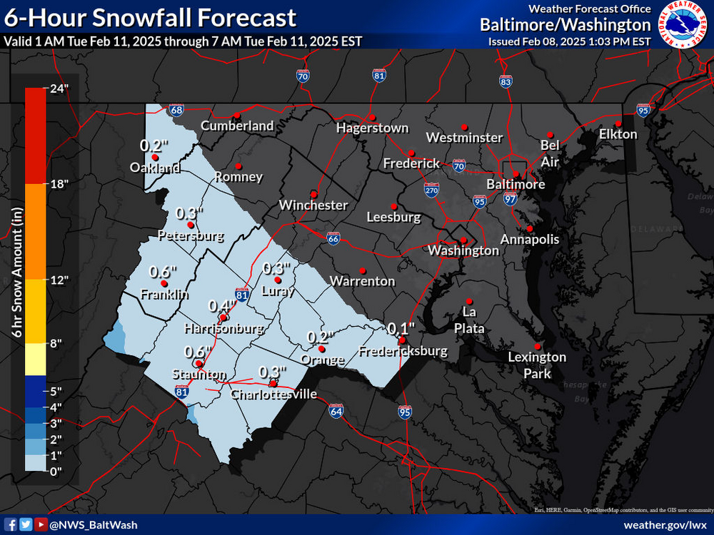
Precip starting to move into the 6-hour forecasts. This is by 7am Tuesday (furthest it goes for now).
-
Afternoon AFD doesn’t even nibble at QPF or watches. 2:33 PM AFD: LONG TERM /TUESDAY THROUGH SATURDAY/... The upcoming week will feature a very active stretch of weather locally, with multiple opportunities for wintry precipitation. Models are in good agreement that on the synoptic scale, there will be upper level ridging in place in the East Pacific/over Alaska, and then also over the North Atlantic/Greenland, with a broad upper low in place over much of Canada. A strong north-south temperature gradient will reside to the south of the upper low over the United States, with a corresponding strong upper jet extending across the CONUS. Multiple disturbances will both undercut the Alaskan ridge, and ride over the ridge within split flow, then rapidly move eastward across the CONUS. The trend over the past few model cycles has been for more confluence over New England resulting in a slightly suppressed storm track Tue. The energy associated with this feature has also trended more strung out as compared to consolidated. This feature will not be fully sampled over the CONUS for another day or so, so the so called wind shield wiper effect of south/north shifts in model output is expected. The first system will exit by 12Z Wed with only a short break in precip before the next precip event arrives midnight Wed night. The primary low pressure system is fcst to track across the upper OH River Valley with guidance indicating a prominent warm nose a mix to rain or all rain more likely. Areas west of the Blue Ridge could see another icing event with this system. A third and more complex system may impact the region next weekend with all types of wintry precip possible. Temps look to stay below normal for daytime highs and near normal for nighttime lows into late Feb aside from residing in the warm sector of any cyclones.
-
Lock it in. Start a thread.
-
Recent January DCA Temperatures Appear Inconsistent with 1981-2010 Normals
NVAwx replied to RodneyS's topic in Mid Atlantic
Is there a website I can easily figure out how many hours we have been above freezing and below freezing since January 1? For instance: How many hours above freezing vs. below freezing at DCA and IAD Number of hours below freezing in a row Etc. -
January Medium/Long Range: Chasing more snow to close out the month
NVAwx replied to mappy's topic in Mid Atlantic
Is there a website I can easily figure out how many hours we have been above freezing and below freezing since January 1? For instance: How many hours above freezing vs. below freezing at DCA and IAD Number of hours below freezing in a row -
Is the severe weather side of the storm progressing as modeled? I recall one storm in the early 2000s where the severe outbreak robbed all the moisture/energy from the snow side.
-
Subtract 5 hours in the winter for EST!
-
but consistent with the LWX forecast I think.

-
Have any of the models shown any ptype issues north and west of DC? With these kuchera totals, it seems all snow?
-
Channeling LWX all day.
-
Feb 2007 and the concrete that ensued?
-
January: Medium/ Long Range: May the Force be with Us....
NVAwx replied to Weather Will's topic in Mid Atlantic
The 95 disaster day. More south. Warm the day before and heavy rates. Lots of tree damage and power outages. -
We needed that reality check. Yall were getting too comfortable.