

Powerball
-
Posts
14,269 -
Joined
-
Last visited
Content Type
Profiles
Blogs
Forums
American Weather
Media Demo
Store
Gallery
Posts posted by Powerball
-
-
DFW is currently at +1.0°F for June. The departure will likely increase further as we head into the final week of the month. If so, while not be record-breaking, that will mean another solidly above average month temp-wise despite the wet soils and all of the rainfall.
There may be a bit of a fly in the ointment though, as there are hints we could at least be grazed by ROF convection out of OK/KS/AR midweek with a transient breakdown of the eastern ridge.
-
59 minutes ago, Powerball said:
DTW did in fact snag an intra-hour 90*F.
Convection is blowing up all around the vicinity now, so in all likelihood, that will be the max for today.
Guess I was wrong. Convection to the SW of the airport fell apart and didn't produce much debris.
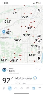
Up to 92*F now as of the 2pm observation.
-
1 hour ago, Powerball said:
Might be a photo finish for 90*F today. Currently 89*F at DTW now, but some Altostratus has filled in per satellite and Convection is starting to initiate just to the SW.
DTW did in fact snag an intra-hour 90*F.
Convection is blowing up all around the vicinity now, so in all likelihood, that will be the max for today.
-
1 hour ago, SolidIcewx said:
Sun is definitely out a lot more than it was last two days. I agree should possibly make a run. Also will see how this afternoons convection is supposed to be. Mind as well keep the streak going.
Might be a photo finish for 90*F today. Currently 89*F at DTW now, but some Altostratus has filled in per satellite and Convection is starting to initiate just to the SW.
-
Looks like potentially several consecutive days of 100*F+ temps are looming for DFW next week, starting as early as this upcoming. Sunday.
For perspective, the first 100*F+ day last year wasn't observed until 6/26 (which ended up with 55 days total).
-
 1
1
-
-
DTW eventually did achieve a late day high of 91*F yesterday, as it seems the cloud debris finally thinned some.
-
21 minutes ago, SolidIcewx said:
Already 89/71/95 here where I’m working. Says 90 today but I think it’s underdone by 2
You guys seem to have a fair amount of cloud debris today. I'm a little surprised temps are still rising at a respectable clip.
But that mid-June sun angle can do wonders...
-
While not record-breaking, 6/17 is the first time DTW reached 95*F or greater since 8/3/2022.
-
 2
2
-
-
15 minutes ago, TheClimateChanger said:
Unfortunately, the de-urban cold island effect is keeping temperatures in check at DTW.
The Detroit area was under the influence of the outflow bubble from this morning's MCS / MCV,
The bubble has finally (mostly) eroded with temps topping out in the low/mid 90s, but the limited daytime mixing through midday put a cap on the max temp potential.
-
1
-
-
OP's thread tag is starting to age like milk...
-
1
-
-
3 hours ago, Stevo6899 said:
6 days in a row in the mid 90's north of detroit. Don't recall the last time we've had this long of a stretch, albeit my memory is terrible.
2011 and 2012...
-
1
-
 1
1
-
-
The GFS really is a terrible model.
-
1
-
-
4 hours ago, Torchageddon said:

One of the best things I've seen modeled in 2024, epic heat on the way for the NE!
And I love that for y'all...

-
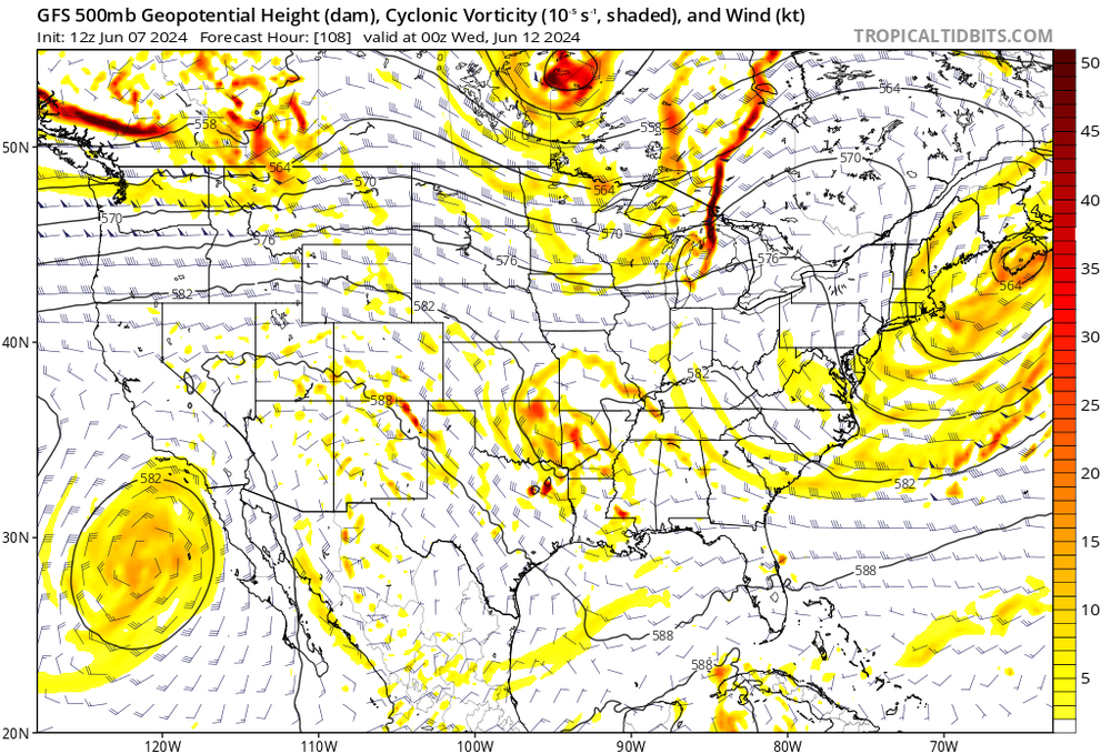
What an awful model the GFS is.
One run, it shows a 600dm ridge over the GL / NE next week, the next run it shows a dirty 582dm ridge with the remnants of a tropical disturbance.
-
3 hours ago, buckeye said:
in fairness I did read a lot of hype about an early, hot dry start to summer. LC was constantly beating the Morch drum all winter. It seems like we haven't been able to keep a true heat wave locked in for quite awhile. Instead it's 2-4 days of above and then a break to equally anomalous lower temps. Kinda wouldn't mind a good ole fashioned shirt soaking lemonade drinking hankerchief wiping heat wave.
Larry Cosgrove wasn't wrong with his prediction of a very warm Spring (although yes, he was wrong about it being dry). 2024 was the 6th warmest Spring on record for the US.
Not even Morch was a wall-to-wall torch the entire month. And even if it were, statistically-speaking, it's unrealistic to hold that or 2012 in general as the standard for a warm temperature pattern.
And yes, Cosgrove was a few weeks too bullish with the transition to eastern ridging / western troughing for Met. Summer. But while delayed, it's definitely still happening.
-
3 hours ago, Ed, snow and hurricane fan said:
Heat ridge still stubbornly refusing to lock in. Another NW flow event next week on all the ensembles. Tuesday afternoon & evening looks like another round of severe weather for NTX if GFS is any guide..
Next week's been shot for a while.
It's the 3rd week of June when it should really lock in.
-
1
-
-
On 6/6/2024 at 8:57 AM, Powerball said:
As mentioned in the other thread, enjoy the next 2 weeks while they last.
Indications are that eastern realignment of the heat ridge should be underway starting the 3rd week of June, which should be the dominant pattern (aside from the occasional transient breakdown with NW flow shortwaves or tropical activity) for the remainder of the Summer.
There won't be any smoke levels of consequence to help obscure solar insolation this time either.

-
4
-
1
-
-
The blame game aside, this is just a reminder that people should not take severe t'storm predictions lightly, as the environment will be conducive to rapidly evolving conditions at a mesoscale level that even Meteorologists may not always be able to proactively warn the public about.
-
1
-
-
As mentioned in the other thread, enjoy the next 2 weeks while they last.
Indications are that eastern realignment of the heat ridge should be underway starting the 3rd week of June, which should be the dominant pattern (aside from the occasional transient breakdown with NW flow shortwaves or tropical activity) for the remainder of the Summer.
There won't be any smoke levels of consequence to help obscure solar insolation this time either.
-
35 minutes ago, SolidIcewx said:
Well that was fun. Just got to experience a wet micro burst. Couldn’t see a damn thing trees going crazy. Somehow have power. I’d definitely say it was a solid 30 seconds of 60-65mph gusts
Y'all are definitely getting the goods.
Seems the city's getting slammed right now too, maybe even with some small hail.
-
2 hours ago, Powerball said:
The MCS is outflow dominant, which is a good thing.
But it has reached here and those winds mean businesss. Easily getting 50 MPH gusts.
Spoke too sonn.
Severe Thunderstorm Warning for the NE half of the Metroplex with 65 MPH winds.
We're getting hit pretty good here now.
Vivid lightning, but oddly enough, not much thunder.
-
The MCS is outflow dominant, which is a good thing.
But it has reached here and those winds mean businesss. Easily getting 50 MPH gusts.
-
10 hours ago, cstrunk said:
Another MCS moving through NE Texas.
Another one likely later tonight/tomorrow morning.
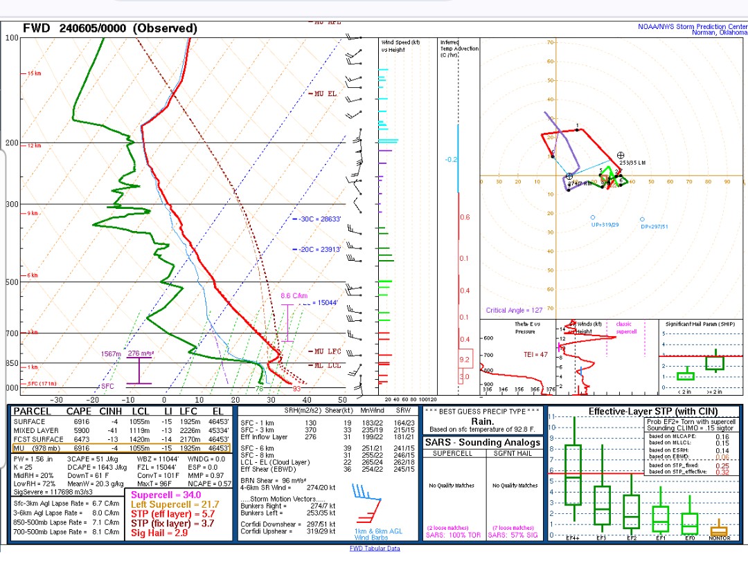
As mentioned, deep layer shear is relatively underwhelming, but otherwise the setup is looking remarkably similar to last Tuesday morning (just a bit further NE).
If the looming MCS can establish a cold pool, it could get hairy.
-
1
-
-


Texas 2024 Discussion/Observations
in Central/Western States
Posted
BTW, 2024 is also the 5th warmest year to-date on record for DFW (warmer than both 2022 and 2023 to-date), even with a January that was well below average.