Powerball
-
Posts
14,135 -
Joined
-
Last visited
Content Type
Profiles
Blogs
Forums
American Weather
Media Demo
Store
Gallery
Everything posted by Powerball
-
https://x.com/JudgeClayJ/status/1795482050860114273?t=HkK7k4QCxR2HHUHOia40gQ&s=19
-
Getting widespread post-storm gusts of 40-50 MPH (wind advisory criteria).
-
Also starting to see some reintensification / redevelopment of storms down around Austin / College Station as the enhanced low level convergence erodes what little capping was in place. Will have to watch and see if it intensifies into a severe QLCS for Houston.
-
Outflow boundary's made it all the way down to Austin and will be pushing westward through San Angelo shortly. In fact, it has prompted a Hgh Wind Warning for the San Angelo area.
-
Just doing a cursory comparison... What's impressive about today's event vs June 2019 is the latter happened during peak heating after a day with plentiful morning sunshine (when the temp/dewpoint spread was much wider, thus in theory would have enhanced the downdraft strength), whereas today's event happened at diurnal minimum. Also, I'm pretty certain the coverage of severe wind in June 2019 was more widespread throghout the Metroplex in June 2019, even if the peak rainfall/wind intensity was somewhat less impressive. Today's event was mostly concentrated in the NE half of DFW (granted, still a ton of people impacted).
-
Per the SPC storm report page, there's major structural damage at North Forney (TX) High School
-
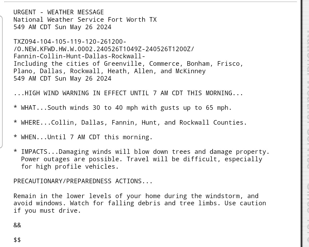
Even the Outflow Boundary itself is packing a punch. This is back out to the west in Abilene... Special Weather Statement National Weather Service San Angelo TX 847 AM CDT Tue May 28 2024 TXZ054-066-113-127-128-139-281445- Runnels TX-Callahan TX-Nolan TX-Coleman TX-Jones TX-Taylor TX- 847 AM CDT Tue May 28 2024 ...STRONG WINDS WILL IMPACT SOUTHERN CALLAHAN...SOUTHWESTERN JONES...NORTHERN COLEMAN...NORTHEASTERN NOLAN...TAYLOR AND NORTHEASTERN RUNNELS COUNTIES THROUGH 945 AM CDT... At 846 AM CDT, Doppler radar was tracking an outflow boundary with strong winds up to 50 mph near Potosi. HAZARD...Wind gusts up to 50 mph. SOURCE...Radar indicated. IMPACT...Gusty winds could knock down tree limbs and blow around unsecured objects. This strong thunderstorm will be near... Potosi around 850 AM CDT. Tuscola around 915 AM CDT. Abilene around 905 AM CDT. Other locations impacted by this storm include Impact, Lake Abilene, Camp Tonkawa, Echo, Lake Sweetwater, Lake Coleman, Ovalo, Hodges, Goldsboro, Buffalo Gap and Camp Butman. This includes Interstate 20 between Mile Markers 256 and 293. PRECAUTIONARY/PREPAREDNESS ACTIONS... If outdoors, consider seeking shelter inside a building. && LAT...LON 3167 9920 3239 10041 3264 9994 3217 9920 TIME...MOT...LOC 1346Z 055DEG 14KT 3233 9962 MAX HAIL SIZE...0.00 IN MAX WIND GUST...50 MPH $$ SK
-
https://x.com/wfaa/status/1795441415318577606?t=DqGQO0gJ8YORVgbih3opxQ&s=19
-
Fortunately, the storms moving through the SW half of the Metroplex right now are outflow dominant. But yes, will definitely have to watch for that outflow to trigger more storms across Central Texas this afternoon, where the atmosphere hasn't been turned over.
-
https://x.com/JMichaelsNews/status/1795407855161610642?t=76AabT3zfSlx6AoyLKDHlw&s=19
-
https://x.com/DFWscanner/status/1795442377903284347?t=UHIxepkf6Lyzvr7K8_VCMQ&s=19
-
Thought about that earlier. Conditions are favorable for this thing to keep going.
-
https://x.com/DallasTexasTV/status/1795446514044572051?t=gvYf0M9PvO5VKSfCHQzgIw&s=19
-
Over 600K without power per Oncor
-
https://x.com/DallasTexasTV/status/1795258528569102576?t=4ZSoTfpKB11Y3sgLi149Tg&s=19
-
Getting wake winds again with the storm having passed. Nothing nearly as intense as the storm itself or even what we saw Sunday morning, but solid 30-40 MPH post-storm gusts EDIT: Wake winds are really picking up now.
-
If there's an upside, at least this happened before rush hour picked up. Another 1-2 hours would have been an even worse mess.
-
This has to be the worst (widespread) hit for the Metroplex since June 2019...
-
Torando Warning now on the cell that just blew here (still going) for Dallas County.
-
And there's the hail, lol...
-
Oh boy, this was a hell of a one. Got a notification for 80 MPH destructive winds right before getting gobsmacked. We lost power almost immediately. It was like a hurricane out there.
-

Texas 2024 Discussion/Observations
Powerball replied to Stx_Thunder's topic in Central/Western States
Looking at the list of top 10 warmest Springs for DFW, once 2024 officially closes out this week, 7 of the top 10 warmest Springs will have occured within the last 20 years. And yes, there's a chance this Spring could end up warmer than 2022 (the last few days of May will challenge that though). -
I mean, only 5 people do. That's virtually no one...
-
Of course, the most "severe weather" action DFW proper has seen this season would be from wake winds of all things. As I said before, what a season!
-