
Maggie Valley Steve
-
Posts
449 -
Joined
-
Last visited
Content Type
Profiles
Blogs
Forums
American Weather
Media Demo
Store
Gallery
Everything posted by Maggie Valley Steve
-

2024-2025 Fall/Winter Mountain Thread
Maggie Valley Steve replied to Buckethead's topic in Southeastern States
We have a snow shower moving into Maggie now. -
2024-2025 Fall/Winter Mountain Thread
Maggie Valley Steve replied to Buckethead's topic in Southeastern States
Yes sir. Looking like a little surprise for the overnight hours even down here in Maggie! Keeping an eye on Sunday evening as well. Absolute prefect conditions for snow making! Ski areas should be rocking over the next 5 to 7 days! -
2024-2025 Fall/Winter Mountain Thread
Maggie Valley Steve replied to Buckethead's topic in Southeastern States
Temperature has dropped from 52 this morning to 44. Stiff wind blowing. Just passed Tube World and they are actually open! Kids were having a blast sliding down the hill! -
2024-2025 Fall/Winter Mountain Thread
Maggie Valley Steve replied to Buckethead's topic in Southeastern States
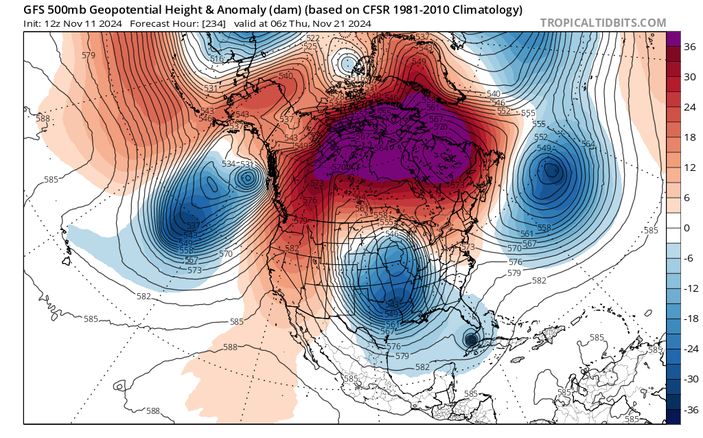
Very chilly air ahead for this weekend with the possibility of some NWFS. A stronger shot of Continental Polar air arriving Sunday afternoon bringing very gusty NW winds that likely will bring Windchill Advisories over the Mountain Counties with a slightly better chance of snow showers, but the models suggest only light accumulations. Perfect chance for snow making over several days! I continue to be intrigued in the late next week timeframe for a more significant winter weather event across our Region. What I find note worthy is the almost complete 180° turn around of those Winter seasonal forecasts. I suspect that we will continue to see the snow pack to our N and W increase and the Sub Tropical jet to become more favorable as December begins. Happy Thanksgiving Mountain Folks! -
2024-2025 Fall/Winter Mountain Thread
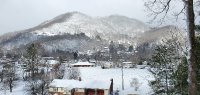
Maggie Valley Steve replied to Buckethead's topic in Southeastern States
Sun is out revealing our snow covered mountains!
-
2024-2025 Fall/Winter Mountain Thread
Maggie Valley Steve replied to Buckethead's topic in Southeastern States
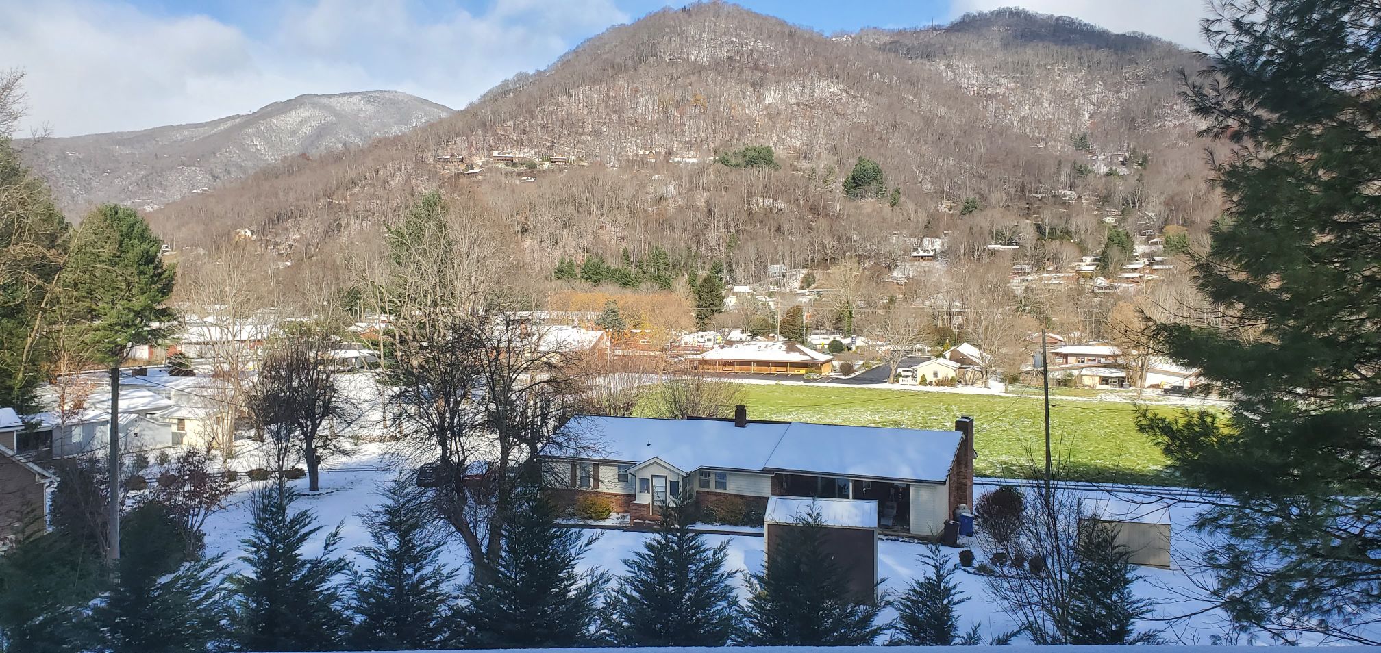
Pouring snow now. Driveway has caved. This storm has certainly over performed my expectations! Keeping an eye on Thanksgiving day into next weekend. Going to be very close to something special. Regardless, the cold looks to settle in for a couple of weeks in early December. -
2024-2025 Fall/Winter Mountain Thread
Maggie Valley Steve replied to Buckethead's topic in Southeastern States
Looking like an inch or two on the ground to the Valley floor. Very light snow continues. Cataloochee made an amazing base at the way to the Top of the Mountain! Opening day? Certainly possible! Their website says opening tomorrow, November 23rd at 8:30 AM! -
2024-2025 Fall/Winter Mountain Thread
Maggie Valley Steve replied to Buckethead's topic in Southeastern States
Light snow with a dusting so far. Decks have a coating as well. -
2024-2025 Fall/Winter Mountain Thread
Maggie Valley Steve replied to Buckethead's topic in Southeastern States
Flurries in Maggie Valley now. -
2024-2025 Fall/Winter Mountain Thread
Maggie Valley Steve replied to Buckethead's topic in Southeastern States
Flurries at Cataloochee. -
2024-2025 Fall/Winter Mountain Thread
Maggie Valley Steve replied to Buckethead's topic in Southeastern States
The lights are on and snow making going full throttle to the Top of the Mountain at Cataloochee Ski Area overnight and this morning! Looking like an opening coming quickly and possibly by Friday or Saturday? The weather certainly will cooperate! I am seeing the potential of another strong cold front around Thanksgiving bringing the possibility of more snow. The extended range sure looks active as well. 33 for my low so far. -
2024-2025 Fall/Winter Mountain Thread
Maggie Valley Steve replied to Buckethead's topic in Southeastern States
Winter Weather Advisories hoisted for the border Counties to Swain County. GSP has me in the 2 to 4 inch range. Carefully watching a more Northerly flow early Friday before a NWFS sets in. -
2024-2025 Fall/Winter Mountain Thread
Maggie Valley Steve replied to Buckethead's topic in Southeastern States
A bit of am uptick via the GFS and ECMWF this afternoon. Both models suggested a bit more vigorous upper air disturbance/lobe dropping more SSE into the Southern Apps. Both suggested a couple inches of accumulation here in the Valley. -
2024-2025 Fall/Winter Mountain Thread
Maggie Valley Steve replied to Buckethead's topic in Southeastern States
Second morning with 32 and heavy frost to the Valley floor. The "warm up" was not so warm here on the N facing mountain. Hoping to see a flurry or two Thursday night! -
2024-2025 Fall/Winter Mountain Thread
Maggie Valley Steve replied to Buckethead's topic in Southeastern States
Yeah we needed the rain. Started out at 41 this morning and currently sitting at 45 with light rain. -
2024-2025 Fall/Winter Mountain Thread
Maggie Valley Steve replied to Buckethead's topic in Southeastern States
This pattern keeps popping up. Makes me think it may have legs
-
2024-2025 Fall/Winter Mountain Thread
Maggie Valley Steve replied to Buckethead's topic in Southeastern States
I am finally seeing signs of a pattern change suggesting at least we get back to seasonal norms regarding temperatures. Looking like the first shot of stronger colder air arrives mid next week followed by several more shots of colder air leading up to Thanksgiving. -
2024-2025 Fall/Winter Mountain Thread
Maggie Valley Steve replied to Buckethead's topic in Southeastern States
No snow at 3200 ft. Just a mix of rain and sleet pellets. Looks like the snow line here was around 4500 ft. Sheep Back Mountain looked nice with snow cover this morning. -
2024-2025 Fall/Winter Mountain Thread
Maggie Valley Steve replied to Buckethead's topic in Southeastern States
Nice to see snow on the ground at Cataloochee this morning. Looks like we may get another chance toward the end of the month. November is coming quickly and hopefully the ski areas open up ahead of schedule! -
2024-2025 Fall/Winter Mountain Thread
Maggie Valley Steve replied to Buckethead's topic in Southeastern States
Just walked the dogs. Light rain and sleet mix. Webcam at Cataloochee shows some light accumulation starting. -
2024-2025 Fall/Winter Mountain Thread
Maggie Valley Steve replied to Buckethead's topic in Southeastern States
Flurries now at Cataloochee Ski Area. -
2024-2025 Fall/Winter Mountain Thread
Maggie Valley Steve replied to Buckethead's topic in Southeastern States
34 with heavy frost to the ground this morning. My point and click forecast from GSP indicates a 50% chance of snow overnight tonight. -
2024-2025 Fall/Winter Mountain Thread
Maggie Valley Steve replied to Buckethead's topic in Southeastern States
The 12Z 3km NAM suggests some accumulation above 5K Tuesday evening into Wednesday. Definitely feeling like a Fall day with a current temperature of 55F..thumb.png.e2ab9e9ebe9f1552b082ba15efc85786.png)
-
2024-2025 Fall/Winter Mountain Thread
Maggie Valley Steve replied to Buckethead's topic in Southeastern States
36 and frost in Maggie. -
2024-2025 Fall/Winter Mountain Thread
Maggie Valley Steve replied to Buckethead's topic in Southeastern States
43 this morning. I'm noticing the longer range guidance suggest much cooler air possibly arriving early to mid next week. I'm praying that the folks still needing to be reached with supplies get what they need soon! The Army arrived in Maggie Sunday afternoon. They've been working with our Town Maintenance crews since arriving!

.png.0086ce86d559667d14b8ce9de5985cd0.png)