Maggie Valley Steve
-
Posts
449 -
Joined
-
Last visited
Content Type
Profiles
Blogs
Forums
American Weather
Media Demo
Store
Gallery
Everything posted by Maggie Valley Steve
-

2024-2025 Fall/Winter Mountain Thread
Maggie Valley Steve replied to Buckethead's topic in Southeastern States
Winter Weather Advisory coming overnight into tomorrow morning for portions of the Mountains with a Hazardous Weather mention for Haywood County as well as other Mountain locations.
-
2024-2025 Fall/Winter Mountain Thread
Maggie Valley Steve replied to Buckethead's topic in Southeastern States
Looking like a sneaky event with a decent CAD in place for Sunday morning particularly for the Northern Mountains. A wintry mix potential is increasing suggesting a Winter Weather Advisory may be needed. -
2024-2025 Fall/Winter Mountain Thread
Maggie Valley Steve replied to Buckethead's topic in Southeastern States
24° here this morning. No snow on my decks this time. I can hear the snow blowers at Tube World still going. It's going to be a great weekend for Winter Weather fun here in the Valley! -
2024-2025 Fall/Winter Mountain Thread
Maggie Valley Steve replied to Buckethead's topic in Southeastern States
Radar out of Nashville and Morristown suggest another disturbance is heading our way for tonight. Temperature has dropped to 30° with occasional flurries and very gusty winds. -
2024-2025 Fall/Winter Mountain Thread
Maggie Valley Steve replied to Buckethead's topic in Southeastern States
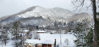
Rain mixed with snow here in Maggie. Cataloochee has snow. -
2024-2025 Fall/Winter Mountain Thread
Maggie Valley Steve replied to Buckethead's topic in Southeastern States
Dropped from 56 to 46 the past hour. Wind just picked up as well. Cataloochee webcams show very low visibility and 44 currently. -
2024-2025 Fall/Winter Mountain Thread
Maggie Valley Steve replied to Buckethead's topic in Southeastern States
Models appear to be struggling with the waves of low pressure riding along the front within a negative tilted trough. Some of the guidance suggests an upper air disturbance following the cold front from the W to NW as well. The wind is going to be howling and very cold air should move in late Wednesday afternoon into Thursday morning. The 3km NAM is depicting a dusting to an inch of snow here in Maggie. If that happens, it will be the third accumulating snow so far this Winter. Still waiting on a bigger storm and perhaps there is something on the horizon just before Christmas. We will see. -
2024-2025 Fall/Winter Mountain Thread
Maggie Valley Steve replied to Buckethead's topic in Southeastern States
This certainly is not a "torch" look for this Thursday.
-
2024-2025 Fall/Winter Mountain Thread
Maggie Valley Steve replied to Buckethead's topic in Southeastern States
Low this morning was 20°. Looking like a brief 'warmup' with rain chances increasing Sunday night into Monday morning. Another shot of cold Canadian air for Wednesday with NWFS. Looking ahead, I continue to be intrigued by the longer range guidance flipping from a late December and January so called "torch" to that of a very anomalous trough and cold air entrenched. The storm track looks active as well. Enjoy the 'thaw' the next several days and the week before Christmas! -
2024-2025 Fall/Winter Mountain Thread
Maggie Valley Steve replied to Buckethead's topic in Southeastern States
Coldest morning of the Season so far. 9° for my low this morning. Looks like Waynesville area was colder with a reliable report of 3°. -
2024-2025 Fall/Winter Mountain Thread
Maggie Valley Steve replied to Buckethead's topic in Southeastern States
I had a low of 20° this morning. I read on X from localyokal that he had a low 13 in Waynesville. One morning shot of Artic air before the 'warmup'. -
2024-2025 Fall/Winter Mountain Thread
Maggie Valley Steve replied to Buckethead's topic in Southeastern States
Another strong shot of Arctic air arrives early Thursday morning across the Mountains with another round of flow snow. The winds will be howling with gusts even down in the valleys near 50 mph. We may see Windchill Advisories with the strong front. -
2024-2025 Fall/Winter Mountain Thread
Maggie Valley Steve replied to Buckethead's topic in Southeastern States
Looks like about an inch fell here. Everything is covered including my driveway and the secondary road to my house. -
2024-2025 Fall/Winter Mountain Thread
Maggie Valley Steve replied to Buckethead's topic in Southeastern States
Snow flurries in Maggie Valley now. -
2024-2025 Fall/Winter Mountain Thread
Maggie Valley Steve replied to Buckethead's topic in Southeastern States
Ceiling has lowered and now light snow up at Cataloochee. -
2024-2025 Fall/Winter Mountain Thread
Maggie Valley Steve replied to Buckethead's topic in Southeastern States
Clouds are spreading over the Mountains quickly now. My temperature has dropped from 38 to 34 the past half. Whatever falls will be very fluffy. -
2024-2025 Fall/Winter Mountain Thread
Maggie Valley Steve replied to Buckethead's topic in Southeastern States
Sure looking like this is the week for clippers. GSP mentioned after tonight another round Wednesday and another chance Thursday in their afternoon disco. -
2024-2025 Fall/Winter Mountain Thread
Maggie Valley Steve replied to Buckethead's topic in Southeastern States
No snow in the Valley, but my low this morning was 27. Good luck tonight! -
2024-2025 Fall/Winter Mountain Thread
Maggie Valley Steve replied to Buckethead's topic in Southeastern States
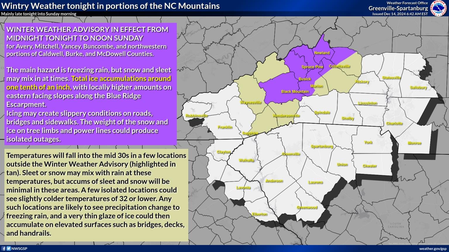
GSP has just updated for tomorrow afternoon into Tuesday. I suspect we'll see Winter Weather Advisories hoisted in the morning for some as a precaution.
-
2024-2025 Fall/Winter Mountain Thread
Maggie Valley Steve replied to Buckethead's topic in Southeastern States
Clouds have rolled in and Cataloochee has snow flurries on their webcams. -
2024-2025 Fall/Winter Mountain Thread
Maggie Valley Steve replied to Buckethead's topic in Southeastern States
It does. The 12Z 3km showed a nice wide swath of snow across Central and Eastern Tennessee with upslope enhancement over the Mountains and lighter amounts into the Piedmont. That NAM suggested possible 2 to 3 inches here in the Valley. We'll see how that pans out. -
2024-2025 Fall/Winter Mountain Thread
Maggie Valley Steve replied to Buckethead's topic in Southeastern States
GSP update for tomorrow afternoon!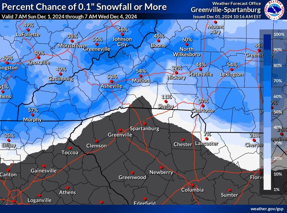
-
2024-2025 Fall/Winter Mountain Thread
Maggie Valley Steve replied to Buckethead's topic in Southeastern States
Low here was 27. Cirrus currently filtering the early morning sun. -
2024-2025 Fall/Winter Mountain Thread
Maggie Valley Steve replied to Buckethead's topic in Southeastern States
Looking like the clipper overnight could produce for the Northern Mountains and the next clipper on Monday night could catch all of us! -
2024-2025 Fall/Winter Mountain Thread
Maggie Valley Steve replied to Buckethead's topic in Southeastern States
Low temperature this morning is 19. Brrrr...