Maggie Valley Steve
-
Posts
449 -
Joined
-
Last visited
Content Type
Profiles
Blogs
Forums
American Weather
Media Demo
Store
Gallery
Everything posted by Maggie Valley Steve
-

2024-2025 Fall/Winter Mountain Thread
Maggie Valley Steve replied to Buckethead's topic in Southeastern States
22° here for the low. Snow is in my point and click forecast for tomorrow morning. I noticed the shortwave currently over Iowa is producing 1 inch per hour snowfall rates. It will be interesting to watch that wave progression today and see if it remains energetic and not moisture starved. The winds tomorrow into Saturday are going to be howling. -
2024-2025 Fall/Winter Mountain Thread
Maggie Valley Steve replied to Buckethead's topic in Southeastern States
This has my attention...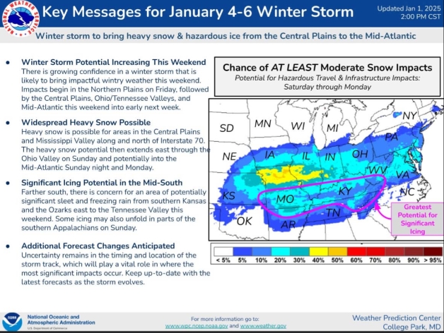
-
2024-2025 Fall/Winter Mountain Thread
Maggie Valley Steve replied to Buckethead's topic in Southeastern States
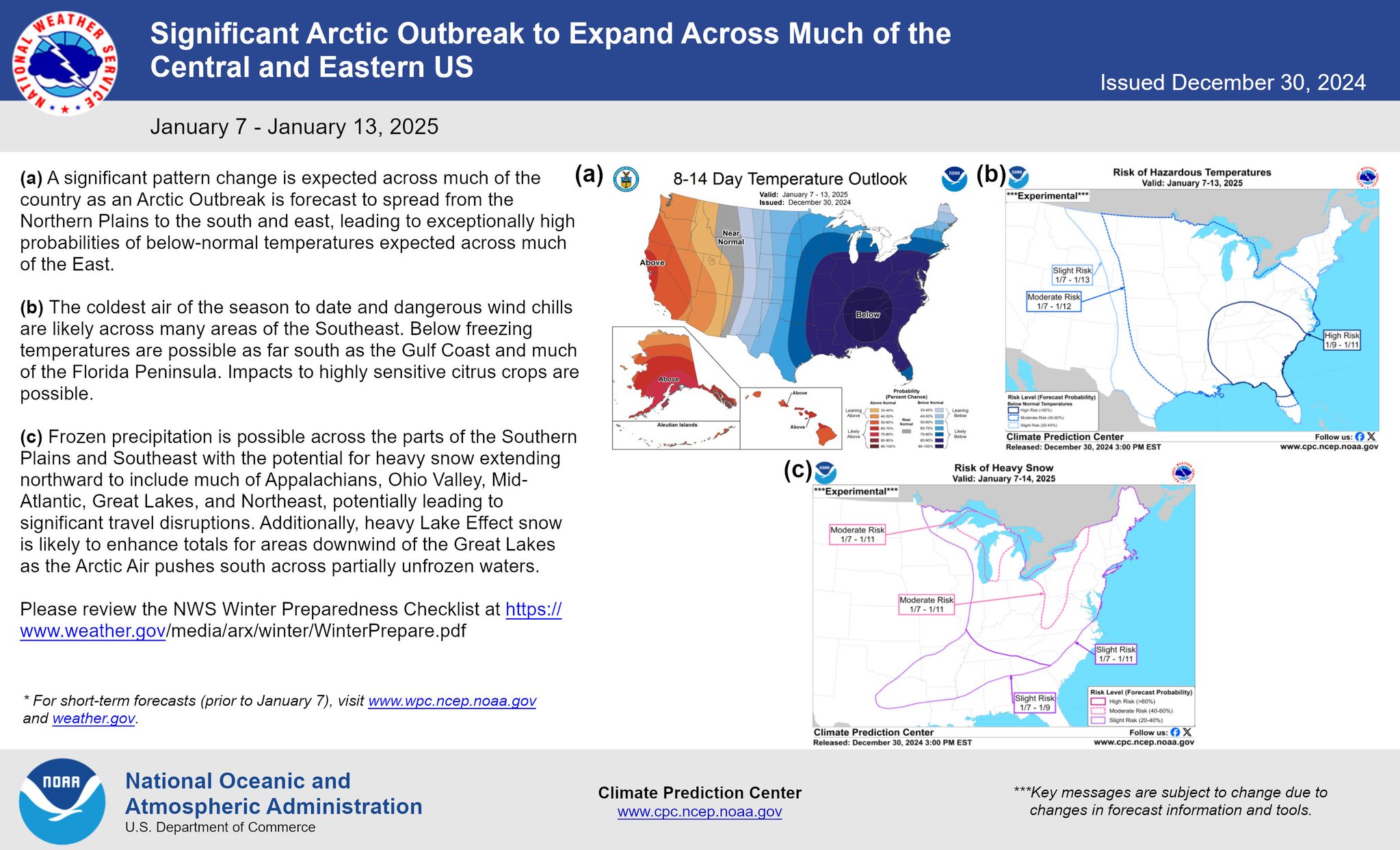
Hazardous Weather Outlook National Weather Service Greenville-Spartanburg SC 243 PM EST Wed Jan 1 2025 NCZ033-048>052-058-021945- Avery-Madison-Yancey-Mitchell-Swain-Haywood-Graham- 243 PM EST Wed Jan 1 2025 This Hazardous Weather Outlook is for western North Carolina. .DAY ONE...This afternoon and tonight. Hazardous weather is not expected at this time. .DAYS TWO THROUGH SEVEN...Thursday through Tuesday. Light snow showers are possible on Friday. Most locations will likely see only a dusting, however some higher elevations along the Tennessee border may receive 1 to 3 inches of accumulation. Strong wind gusts will become increasingly likely as Friday wears on and wind chill values Friday night may fall below zero. .SPOTTER INFORMATION STATEMENT... None. -
2024-2025 Fall/Winter Mountain Thread
Maggie Valley Steve replied to Buckethead's topic in Southeastern States
Upper air pattern continues to waffle with no reliability in any one solution. Models have always struggled with these very cold patterns and the depth of the very cold air. Personally, I believe the 6th is not lost for our area and likely we will see Winter Storm Watches hoisted Saturday evening. I also believe we will see multiple disturbances rotating across the Mountains beyond the 6th offering additional opportunities for snow showers. -
2024-2025 Fall/Winter Mountain Thread
Maggie Valley Steve replied to Buckethead's topic in Southeastern States
Just came over Soco Gap and it was snowing moderately. Sleet/snow mix at the house now. -
2024-2025 Fall/Winter Mountain Thread
Maggie Valley Steve replied to Buckethead's topic in Southeastern States
Happy New Year Mountain Folk. Here's to a much better 2025 for Everyone! -
2024-2025 Fall/Winter Mountain Thread
Maggie Valley Steve replied to Buckethead's topic in Southeastern States
And another lobe in Canada heading down as well . -
2024-2025 Fall/Winter Mountain Thread
Maggie Valley Steve replied to Buckethead's topic in Southeastern States
Brutal...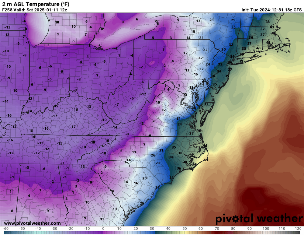
-
2024-2025 Fall/Winter Mountain Thread
Maggie Valley Steve replied to Buckethead's topic in Southeastern States
The Weather Prediction Center starting to ramp up ahead of the events...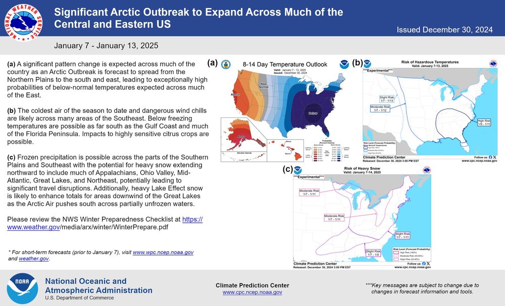
-
2024-2025 Fall/Winter Mountain Thread
Maggie Valley Steve replied to Buckethead's topic in Southeastern States
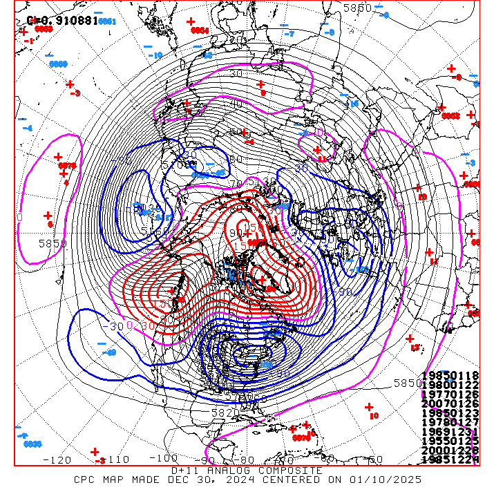
There sure are a lot of memorable winter analogs showing up in today's updated CPC Day 8+ and Day 11+ Analogs.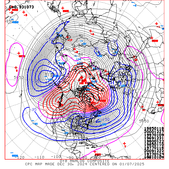
-
2024-2025 Fall/Winter Mountain Thread
Maggie Valley Steve replied to Buckethead's topic in Southeastern States
Been doing this weather thing for over 50 years and I've seen a lot of changes and improvement in technology during those years. In my experience, big time weather events/patterns are known in advance, some with a significant lead time. Big Arctic Outbreaks I've seen have had a week to 10 day period of hints in the guidance, mainly the ensembles of the reliable globals. Throw in all of the teleconnection indices pointing to a favorable possibility, I believe we may well be headed to an active and memorable time period beginning January 1st with the initial cold front stepping down with each of the flowing fronts. This may be one of the more prolonged periods for winter weather not seen in a number of years. Some the analogs are certainly pointing to that potential. Meanwhile it's almost 70° here in the Valley and tornadoes are once again spinning up in the Houston metro area. Changes, they are comin... -
My old friend from SE Texas Larry Cosgrove had a very encouraging synopsis on our upcoming cold pattern tonight on Facebook. We all continue to see a very promising episode of an active storm track and much below temperatures. Fingers crossed that everyone scores during the upcoming pattern! I appreciate the imput you folks provide and Happy New Year to our neighbors on the other side of the mountains!
-
2024-2025 Fall/Winter Mountain Thread
Maggie Valley Steve replied to Buckethead's topic in Southeastern States
We've got to get through the weekend and the heavy rainfall threat before the pattern starts to change. Guidance is indicating the possibility of an inch or two with locally higher amounts this weekend. There could be some potential for isolated flooding concerns for creeks and streams. As Tyler mentioned, the GFS and ECMWF suggest the possibility of a disturbance riding out off Coastal Texas toward us as we begin 2025. -
2024-2025 Fall/Winter Mountain Thread
Maggie Valley Steve replied to Buckethead's topic in Southeastern States
Merry Christmas Mountain Neighbors! Looking forward to be watching the upcoming weather pattern next week! For me, the weather is perfect for Christmas Day. -
2024-2025 Fall/Winter Mountain Thread
Maggie Valley Steve replied to Buckethead's topic in Southeastern States
22° in the smokie Valley this morning. We had a big fire at the Heart of the Valley Motel Saturday which was housing our displaced neighbors from Helene. With the inversion, the smoke from that smoldering fire is trapped in the Valley. -
2024-2025 Fall/Winter Mountain Thread
Maggie Valley Steve replied to Buckethead's topic in Southeastern States
18° here in the Valley this morning. Clear skies and nice half moon. -
2024-2025 Fall/Winter Mountain Thread
Maggie Valley Steve replied to Buckethead's topic in Southeastern States
Surprisingly, we've had flurries most of the day as well! Nice Christmas mood 'feel'. The overnight snow on the ground has melted due to ground temps here in the Valley. Elevations above 4000ft have had snow all day. -
2024-2025 Fall/Winter Mountain Thread
Maggie Valley Steve replied to Buckethead's topic in Southeastern States
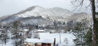
Looking N from my front porch.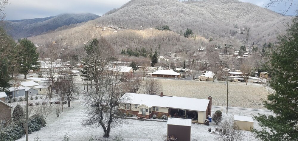
-
2024-2025 Fall/Winter Mountain Thread
Maggie Valley Steve replied to Buckethead's topic in Southeastern States
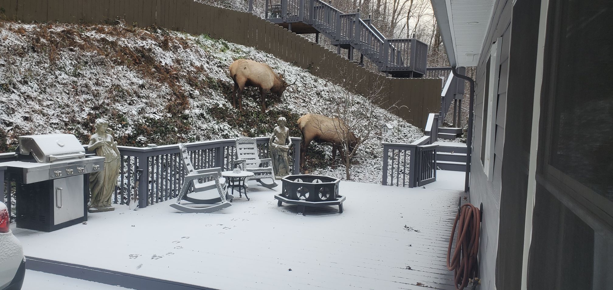
Waking up to just a dusting. There were 6 bulls at backdoor this morning too!
-
2024-2025 Fall/Winter Mountain Thread
Maggie Valley Steve replied to Buckethead's topic in Southeastern States
Currently light snow dusting the decks. -
2024-2025 Fall/Winter Mountain Thread
Maggie Valley Steve replied to Buckethead's topic in Southeastern States
Graupel in Maggie now. Temperature dropped 10° in 15 minutes. Now 38° and falling. Edit to add, I encourage folks to download the mPing app. It was developed by Oklahoma University and NASA to provide a platform for the public to submit reports live. Those reports are monitored by our National Weather Service real time and the reports show up quickly on the app. It's great to see those reports and is informative to see what's going on around us! -
2024-2025 Fall/Winter Mountain Thread
Maggie Valley Steve replied to Buckethead's topic in Southeastern States
My experience suggests not to fully trust those longer range MJO charts. As of recently, there has been too much volatility. Remember just last week they were suggesting a high amplitude Phase 7. My hunch is the pattern is nearing a reshuffle. Remember that we were to be 'torching' all the way to Christmas. That idea has collapsed with 10 to 15 degrees below normal arriving this weekend into at least Tuesday, possibly a day or two longer. -
2024-2025 Fall/Winter Mountain Thread
Maggie Valley Steve replied to Buckethead's topic in Southeastern States
Looking like a Winter Weather Advisory event with generally 1 to 3 inches. Asheville and possibly Hendersonville could see snow showers breaking containment. -
2024-2025 Fall/Winter Mountain Thread
Maggie Valley Steve replied to Buckethead's topic in Southeastern States
Thunderstorms with pea sized hail covering the driveway at this time. -
2024-2025 Fall/Winter Mountain Thread
Maggie Valley Steve replied to Buckethead's topic in Southeastern States
Waking up to a muggy 56° this morning. Cold front arrives Wednesday night/Thursday morning dropping temperatures back to at least normal if not colder. Maybe a slight chance of NWFS, but keeping a closer eye on the weekend. The guidance has switched to a neutral/slightly negative trough and a much stronger shortwave diving in from the Great Lakes. Snow chance have increased and the transfer of low level energy has moved closer to the Coast. I'll be watching so see if the trends continue.