Maggie Valley Steve
-
Posts
449 -
Joined
-
Last visited
Content Type
Profiles
Blogs
Forums
American Weather
Media Demo
Store
Gallery
Everything posted by Maggie Valley Steve
-

2024-2025 Fall/Winter Mountain Thread
Maggie Valley Steve replied to Buckethead's topic in Southeastern States
Looking like we're going to get a storm! I think a 5 to 8 inch snowfall is looking good. The SW Mountains could see some isolated totals nearing a foot. -
2024-2025 Fall/Winter Mountain Thread
Maggie Valley Steve replied to Buckethead's topic in Southeastern States
Surprisingly I picked up an inch and a half overnight. 21° and lightly snowing. -
2024-2025 Fall/Winter Mountain Thread
Maggie Valley Steve replied to Buckethead's topic in Southeastern States
Looks like I've got a solid dusting to a half inch. Still snowing, so we'll see if an inch is possible by morning! -
2024-2025 Fall/Winter Mountain Thread
Maggie Valley Steve replied to Buckethead's topic in Southeastern States
Driveway is covered Currently 25° -
2024-2025 Fall/Winter Mountain Thread
Maggie Valley Steve replied to Buckethead's topic in Southeastern States
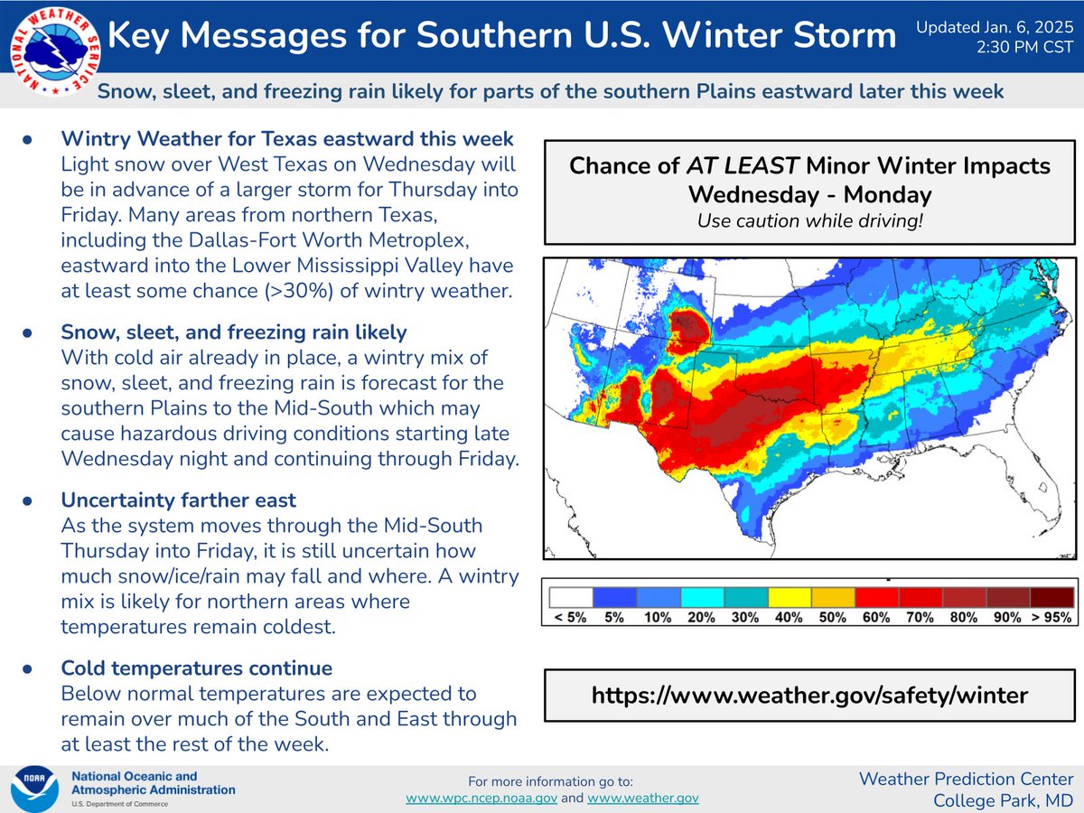
WPC afternoon update for Thursday into Saturday...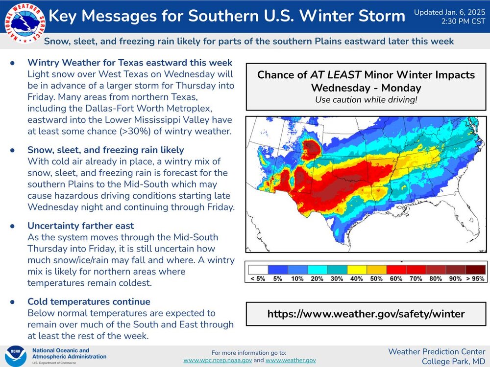
-
2024-2025 Fall/Winter Mountain Thread
Maggie Valley Steve replied to Buckethead's topic in Southeastern States
Intermittent snow showers with tiny flakes. Going to be hard to accumulate here it appears. -
2024-2025 Fall/Winter Mountain Thread
Maggie Valley Steve replied to Buckethead's topic in Southeastern States
Graupel and light rain mix at the house. Temperature has dropped to 39° -
2024-2025 Fall/Winter Mountain Thread
Maggie Valley Steve replied to Buckethead's topic in Southeastern States
Light snow at Cataloochee. -
2024-2025 Fall/Winter Mountain Thread
Maggie Valley Steve replied to Buckethead's topic in Southeastern States
Arctic front has arrived with very gusty winds falling temperatures. It won't be long before the upslope begins as clouds and ceilings are lowering over the Cataloochee Mountains. -
2024-2025 Fall/Winter Mountain Thread
Maggie Valley Steve replied to Buckethead's topic in Southeastern States
I'm not worried about the Friday event. The ensembles and National Blend are all showing snow with no mixing issues at this point. Obviously the finer details will be worked out throughout the week, but to me that is enough of a signal at this range to suggest we have a good shot of accumulating snow even in Asheville and likely the foothills. -
2024-2025 Fall/Winter Mountain Thread
Maggie Valley Steve replied to Buckethead's topic in Southeastern States
Starting out the day at 48°. Had sunshine like Met1985, but clouds have rolled back in. Welcome Ryno23. -
2024-2025 Fall/Winter Mountain Thread
Maggie Valley Steve replied to Buckethead's topic in Southeastern States
Currently 42° in the Valley. We're safe here from any icy weather overnight. That wind is howling though. -
2024-2025 Fall/Winter Mountain Thread
Maggie Valley Steve replied to Buckethead's topic in Southeastern States
Seeing the blues indicate a 60 to 70% chance at range. If the trends continue, I suspect we'll begin seeing Winter Weather products from the WPC as early as tomorrow afternoon. -
2024-2025 Fall/Winter Mountain Thread
Maggie Valley Steve replied to Buckethead's topic in Southeastern States
Sleet now at the house. -
2024-2025 Fall/Winter Mountain Thread
Maggie Valley Steve replied to Buckethead's topic in Southeastern States
Hard not to like the 12Z GFS solution. Dropped 8 inches here starting midday Friday. Going to be an interesting week. -
2024-2025 Fall/Winter Mountain Thread
Maggie Valley Steve replied to Buckethead's topic in Southeastern States
Snow flurries at Cataloochee. -
2024-2025 Fall/Winter Mountain Thread
Maggie Valley Steve replied to Buckethead's topic in Southeastern States
The 12Z 12km NAM increases the amount of wintry weather across the area. Actually the snow total increased, particularly the NWFS tomorrow into Tuesday morning. One thing for sure, it's going to get very cold this week with s snow pack close by. GSP has me with a 40 to 50% chance of snow for a 24 hour period beginning early Friday. -
2024-2025 Fall/Winter Mountain Thread
Maggie Valley Steve replied to Buckethead's topic in Southeastern States
Temperature has risen from 25° at 5 this morning to 30° now. Moisture is heading our way and it's going to be interesting to see what the initial onset will bring. My point and click forecast suggests a rain/snow mix. -
2024-2025 Fall/Winter Mountain Thread
Maggie Valley Steve replied to Buckethead's topic in Southeastern States
This one has definitely over achieved expectations. I've been getting off and on squalls this afternoon and the roads have been covered. I'm nearing an inch now after the noon melt off. -
2024-2025 Fall/Winter Mountain Thread
Maggie Valley Steve replied to Buckethead's topic in Southeastern States
Snow showers have moved back in and it's actually sticking to the driveway and decks as the gusty winds pick up and temperature drops. -
2024-2025 Fall/Winter Mountain Thread
Maggie Valley Steve replied to Buckethead's topic in Southeastern States
I ended up with a dusting, but the sun is breaking through and the snow has melted on the Valley floor. -
2024-2025 Fall/Winter Mountain Thread
Maggie Valley Steve replied to Buckethead's topic in Southeastern States
Snow flurries at the house. -
2024-2025 Fall/Winter Mountain Thread
Maggie Valley Steve replied to Buckethead's topic in Southeastern States
Moderate snow at Cataloochee now. Looks like decent quarters falling. -
2024-2025 Fall/Winter Mountain Thread
Maggie Valley Steve replied to Buckethead's topic in Southeastern States
Ceiling is beginning to lower and snow showers are moving over the Cataloochee Mountains now. -
2024-2025 Fall/Winter Mountain Thread
Maggie Valley Steve replied to Buckethead's topic in Southeastern States
Clouds have finally rolled in and Webcam's at Hemphill Bald and Cataloochee show snow flurries now.